Gmina Ostrów Lubelski

Last updated
Gmina Ostrów Lubelski
Ostrów Lubelski Commune
Gmina
POL Ostrow Lubelski COA.svg
Coat of arms
Lub Lubartowski Ostrow Lubelski.png
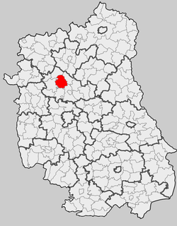
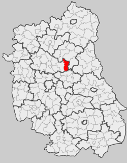
Location within the county and voivodeship
Coordinates(Ostrów Lubelski): 51°29′28″N22°51′18″E / 51.49111°N 22.85500°E / 51.49111; 22.85500 Coordinates: 51°29′28″N22°51′18″E / 51.49111°N 22.85500°E / 51.49111; 22.85500
CountryFlag of Poland.svg  Poland
Voivodeship Lublin
County Lubartów
Seat Ostrów Lubelski
Area
  Total 121.7 km2 (47.0 sq mi)
Population (2015 [1] )
  Total 5,349
  Density 44/km2 (110/sq mi)
   Urban 2,146
  Rural 3,203
Website http://www.ostrowlubelski.lubelskie.pl/

Gmina Ostrów Lubelski is an urban-rural gmina (administrative district) in Lubartów County, Lublin Voivodeship, in eastern Poland. Its seat is the town of Ostrów Lubelski, which lies approximately 18 kilometres (11 mi) east of Lubartów and 34 km (21 mi) north-east of the regional capital Lublin.

Gmina administrative division of Poland

The gmina is the principal unit of the administrative division of Poland, similar to a municipality. As of 2010 there were 2,478 gminy throughout the country. The word gmina derives from the German word Gemeinde, meaning "community".

Lubartów County County in Lublin, Poland

Lubartów County is a unit of territorial administration and local government (powiat) in Lublin Voivodeship, eastern Poland. It was established on January 1, 1999, as a result of the Polish local government reforms passed in 1998. Its administrative seat and largest town is Lubartów, which lies 25 kilometres (16 mi) north of the regional capital Lublin. The county also contains the towns of Kock, lying 23 km (14 mi) north-west of Lubartów, and Ostrów Lubelski, 18 km (11 mi) east of Lubartów.

Lublin Voivodeship Voivodeship in Poland

Lublin Voivodeship, or Lublin Province, is a voivodeship, or province, located in southeastern Poland. It was created on January 1, 1999, out of the former Lublin, Chełm, Zamość, Biała Podlaska and (partially) Tarnobrzeg and Siedlce Voivodeships, pursuant to Polish local government reforms adopted in 1998. The province is named after its largest city and regional capital, Lublin, and its territory is made of four historical lands: the western part of the voivodeship, with Lublin itself, belongs to Lesser Poland, the eastern part of Lublin Area belongs to Red Ruthenia, and the northeast belongs to Polesie and Podlasie.

Contents

The gmina covers an area of 121.7 square kilometres (47.0 sq mi), and as of 2006 its total population is 5,630 (out of which the population of Ostrów Lubelski amounts to 2,245, and the population of the rural part of the gmina is 3,385).

Neighbouring gminas

Gmina Ostrów Lubelski is bordered by the gminas of Ludwin, Niedźwiada, Parczew, Serniki, Spiczyn and Uścimów.

Gmina Ludwin is a rural gmina in Łęczna County, Lublin Voivodeship, in eastern Poland. Its seat is the village of Ludwin, which lies approximately 4 kilometres (2 mi) north of Łęczna and 25 km (16 mi) east of the regional capital Lublin.

Gmina Niedźwiada Gmina in Lublin, Poland

Gmina Niedźwiada is a rural gmina in Lubartów County, Lublin Voivodeship, in eastern Poland. Its seat is the village of Niedźwiada, which lies approximately 10 kilometres (6 mi) north-east of Lubartów and 34 km (21 mi) north of the regional capital Lublin.

Gmina Parczew Gmina in Lublin, Poland

Gmina Parczew is an urban-rural gmina in Parczew County, Lublin Voivodeship, in eastern Poland. Its seat is the town of Parczew, which lies approximately 48 kilometres (30 mi) north-east of the regional capital Lublin.

Villages

The gmina contains the following villages having the status of sołectwo: Bójki, Jamy, Kaznów, Kaznów-Kolonia, Kolechowice Drugie, Kolechowice Pierwsze, Kolechowice-Folwark, Kolechowice-Kolonia, Rozkopaczew (sołectwos: Rozkopaczew I and Rozkopaczew II), Rudka Kijańska and Wólka Stara Kijańska.

A sołectwo(listen) is an administrative unit in Poland, an optional subdivision of a gmina. In many cases it consists of one village, but sometimes large villages may be divided into several sołectwos, while in other cases one sołectwo may consist of several villages or hamlets. Like the dzielnica and osiedle, a sołectwo is an auxiliary unit of a gmina. Only rural locations are assigned to sołectwos, while the comparable administrative unit in town is either dzielnica or osiedle.

Bójki Village in Lublin, Poland

Bójki is a village in the administrative district of Gmina Ostrów Lubelski, within Lubartów County, Lublin Voivodeship, in eastern Poland. It lies approximately 5 kilometres (3 mi) north of Ostrów Lubelski, 19 km (12 mi) north-east of Lubartów, and 38 km (24 mi) north-east of the regional capital Lublin.

Jamy is a village in the administrative district of Gmina Ostrów Lubelski, within Lubartów County, Lublin Voivodeship, in eastern Poland.

Demography

2015TotalWomenMen
Population534926732676
Density44.021.922.1

Area

It spans an area of 121.7 square kilometers, including:

Related Research Articles

Gmina Lubartów Gmina in Lublin, Poland

Gmina Lubartów is a rural gmina in Lubartów County, Lublin Voivodeship, in eastern Poland. Its seat is the town of Lubartów, although the town is not part of the territory of the gmina.

Gmina Firlej Gmina in Lublin, Poland

Gmina Firlej is a rural gmina in Lubartów County, Lublin Voivodeship, in eastern Poland. Its seat is the village of Firlej, which lies approximately 12 kilometres (7 mi) north-west of Lubartów and 35 km (22 mi) north of the regional capital Lublin.

Gmina Michów Gmina in Lublin, Poland

Gmina Michów is a rural gmina in Lubartów County, Lublin Voivodeship, in eastern Poland. Its seat is the village of Michów, which lies approximately 21 kilometres (13 mi) west of Lubartów and 36 km (22 mi) north-west of the regional capital Lublin.

Gmina Ostrówek, Lublin Voivodeship Gmina in Lublin, Poland

Gmina Ostrówek is a rural gmina in Lubartów County, Lublin Voivodeship, in eastern Poland. Its seat is the village of Ostrówek, which lies approximately 13 kilometres (8 mi) north of Lubartów and 37 km (23 mi) north of the regional capital Lublin.

Gmina Serniki Gmina in Lublin, Poland

Gmina Serniki is a rural gmina in Lubartów County, Lublin Voivodeship, in eastern Poland. Its seat is the village of Serniki, which lies approximately 6 kilometres (4 mi) south-east of Lubartów and 22 km (14 mi) north of the regional capital Lublin.

Gmina Uścimów Gmina in Lublin, Poland

Gmina Uścimów is a rural gmina in Lubartów County, Lublin Voivodeship, in eastern Poland. Its seat is the village of Uścimów, which lies approximately 24 kilometres (15 mi) east of Lubartów and 36 km (22 mi) north-east of the regional capital Lublin.

Gmina Wojsławice is a rural gmina in Chełm County, Lublin Voivodeship, in eastern Poland. Its seat is the village of Wojsławice, which lies approximately 26 kilometres (16 mi) south of Chełm and 78 km (48 mi) south-east of the regional capital Lublin.

Gmina Dzwola is a rural gmina in Janów Lubelski County, Lublin Voivodeship, in eastern Poland. Its seat is the village of Dzwola, which lies approximately 11 kilometres (7 mi) east of Janów Lubelski and 61 km (38 mi) south of the regional capital Lublin.

Gmina Spiczyn is a rural gmina in Łęczna County, Lublin Voivodeship, in eastern Poland. Its seat is the village of Spiczyn, which lies approximately 10 kilometres (6 mi) north-west of Łęczna and 18 km (11 mi) north-east of the regional capital Lublin.

Gmina Jarczów is a rural gmina in Tomaszów Lubelski County, Lublin Voivodeship, in eastern Poland. Its seat is the village of Jarczów, which lies approximately 14 kilometres (9 mi) east of Tomaszów Lubelski and 118 km (73 mi) south-east of the regional capital Lublin.

Gmina Łaszczów is an urban-rural gmina in Tomaszów Lubelski County, Lublin Voivodeship, in eastern Poland. Its seat is the town of Łaszczów, which lies approximately 25 kilometres (16 mi) east of Tomaszów Lubelski and 114 km (71 mi) south-east of the regional capital Lublin.

Gmina Rachanie is a rural gmina in Tomaszów Lubelski County, Lublin Voivodeship, in eastern Poland. Its seat is the village of Rachanie, which lies approximately 14 kilometres (9 mi) north-east of Tomaszów Lubelski and 105 km (65 mi) south-east of the regional capital Lublin.

Gmina Tarnawatka Gmina in Lublin, Poland

Gmina Tarnawatka is a rural gmina in Tomaszów Lubelski County, Lublin Voivodeship, in eastern Poland. Its seat is the village of Tarnawatka, which lies approximately 10 kilometres (6 mi) north of Tomaszów Lubelski and 98 km (61 mi) south-east of the regional capital Lublin.

Gmina Tyszowce is an urban-rural gmina in Tomaszów Lubelski County, Lublin Voivodeship, in eastern Poland. Its seat is the town of Tyszowce, which lies approximately 28 kilometres (17 mi) north-east of Tomaszów Lubelski and 107 km (66 mi) south-east of the regional capital Lublin.

Gmina Ulhówek is a rural gmina in Tomaszów Lubelski County, Lublin Voivodeship, in eastern Poland, on the border with Ukraine. Its seat is the village of Ulhówek, which lies approximately 26 kilometres (16 mi) east of Tomaszów Lubelski and 123 km (76 mi) south-east of the regional capital Lublin.

Rudka Kijańska Village in Lublin, Poland

Rudka Kijańska is a village in the administrative district of Gmina Ostrów Lubelski, within Lubartów County, Lublin Voivodeship, in eastern Poland. It lies approximately 7 kilometres (4 mi) south of Ostrów Lubelski, 19 km (12 mi) east of Lubartów, and 30 km (19 mi) north-east of the regional capital Lublin.

References