Gmina Szydłowiec

Last updated
Gmina Szydłowiec
Szydłowiec Commune
Gmina
POL Szydlowiec COA.svg
Coat of arms
POL powiat szydlowiecki map.gif
Coordinates(Szydłowiec): 51°14′N20°51′E / 51.233°N 20.850°E / 51.233; 20.850 Coordinates: 51°14′N20°51′E / 51.233°N 20.850°E / 51.233; 20.850
CountryFlag of Poland.svg  Poland
Voivodeship Masovian
County Szydłowiec
Seat Szydłowiec
Area
  Total 138.15 km2 (53.34 sq mi)
Population (2006)
  Total 19,290
  Density 140/km2 (360/sq mi)
   Urban 12,030
  Rural 7,260
Website http://www.szydlowiec.pl

Gmina Szydłowiec is an urban-rural gmina (administrative district) in Szydłowiec County, Masovian Voivodeship, in east-central Poland. Its seat is the town of Szydłowiec, which lies approximately 110 kilometres (68 mi) south of Warsaw.

Gmina administrative division of Poland

The gmina is the principal unit of the administrative division of Poland, similar to a municipality. As of 2010 there were 2,478 gminy throughout the country. The word gmina derives from the German word Gemeinde, meaning "community".

Szydłowiec County County in Masovian, Poland

Szydłowiec County is a unit of territorial administration and local government (powiat) in Masovian Voivodeship, east-central Poland. It came into being on January 1, 1999, as a result of the Polish local government reforms passed in 1998. Its administrative seat and only town is Szydłowiec, which lies 110 kilometres (68 mi) south of Warsaw.

Masovian Voivodeship Voivodeship in Poland

Mazovian Voivodeship or Mazovia Province is the largest and most populous of the 16 Polish provinces, or voivodeships, created in 1999. It occupies 35,579 square kilometres (13,737 sq mi) of east-central Poland, and has 5,324,500 inhabitants. Its principal cities are Warsaw in the centre of the Warsaw metropolitan area, Radom (226,000) in the south, Płock (127,000) in the west, Siedlce (77,000) in the east, and Ostrołęka (55,000) in the north. The capital of the voivodeship is the national capital, Warsaw.

Contents

The gmina covers an area of 138.15 square kilometres (53.3 sq mi), and as of 2006 its total population is 19,290 (out of which the population of Szydłowiec amounts to 12,030, and the population of the rural part of the gmina is 7,260).

Villages

Apart from the town of Szydłowiec, Gmina Szydłowiec contains the villages and settlements of Barak, Chustki, Ciechostowice, Długosz, Hucisko, Jankowice, Korzyce, Krzcięcin, Łazy, Majdów, Marywil, Mszadla, Omięcin, Rybianka, Sadek, Świerczek, Świniów, Szydłówek, Wilcza Wola, Wola Korzeniowa, Wysocko, Wysoka, Zastronie and Zdziechów.

Barak, Masovian Voivodeship Village in Masovian, Poland

Barak is a village in the administrative district of Gmina Szydłowiec, within Szydłowiec County, Masovian Voivodeship, in east-central Poland. It lies approximately 4 kilometres (2 mi) south of Szydłowiec and 114 km (71 mi) south of Warsaw.

Chustki Village in Masovian, Poland

Chustki is a village in the administrative district of Gmina Szydłowiec, within Szydłowiec County, Masovian Voivodeship, in east-central Poland. It lies approximately 8 kilometres (5 mi) north-east of Szydłowiec and 104 km (65 mi) south of Warsaw.

Ciechostowice Village in Masovian, Poland

Ciechostowice is a village in the administrative district of Gmina Szydłowiec, within Szydłowiec County, Masovian Voivodeship, in east-central Poland. It lies approximately 9 kilometres (6 mi) south-west of Szydłowiec and 118 km (73 mi) south of Warsaw.

Neighbouring gminas

Gmina Szydłowiec is bordered by the town of Skarżysko-Kamienna and by the gminas of Bliżyn, Chlewiska, Jastrząb, Mirów, Orońsko, Skarżysko Kościelne and Wieniawa.

Skarżysko-Kamienna Place in Świętokrzyskie, Poland

Skarżysko-Kamiennapronounced [skarˈʐɨskɔ kaˈmʲɛnːa](listen) is a town in northern Świętokrzyskie Voivodeship in Poland by Kamienna river, to the north of Świętokrzyskie Mountains; one of the voivodship's major towns. Prior to 1928, it bore the name of Kamienna; in less formal contexts usually only the first part of the name (Skarżysko) is used. It belongs to historic Polish province of Lesser Poland.

Gmina Bliżyn is a rural gmina in Skarżysko County, Świętokrzyskie Voivodeship, in south-central Poland. Its seat is the village of Bliżyn, which lies approximately 12 kilometres (7 mi) west of Skarżysko-Kamienna and 27 km (17 mi) north of the regional capital Kielce.

Gmina Chlewiska is a rural gmina in Szydłowiec County, Masovian Voivodeship, in east-central Poland. Its seat is the village of Chlewiska, which lies approximately 7 kilometres (4 mi) west of Szydłowiec and 110 km (68 mi) south of Warsaw. The gmina covers an area of 124.2 square kilometres (48.0 sq mi), and as of 2006 its total population is 6,196.

Related Research Articles

Starachowice County County in Świętokrzyskie, Poland

Starachowice County is a unit of territorial administration and local government (powiat) in Świętokrzyskie Voivodeship, south-central Poland. It came into being on January 1, 1999, as a result of the Polish local government reforms passed in 1998. Its administrative seat and largest town is Starachowice, which lies 37 kilometres (23 mi) north-east of the regional capital Kielce. The only other town in the county is Wąchock, lying 5 km (3 mi) north-west of Starachowice.

Końskie County County in Świętokrzyskie, Poland

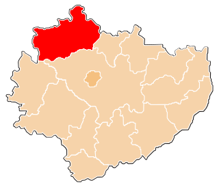
Końskie County is a unit of territorial administration and local government (powiat) in Świętokrzyskie Voivodeship, central Poland. It came into being on January 1, 1999, as a result of the Polish local government reforms passed in 1998. Its administrative seat and largest town is Końskie, which lies 38 kilometres (24 mi) north of the regional capital Kielce. The only other town in the county is Stąporków, lying 11 km (7 mi) south-east of Końskie.

Skarżysko County County in Świętokrzyskie, Poland

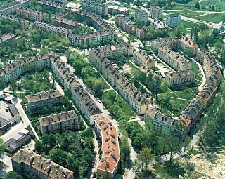
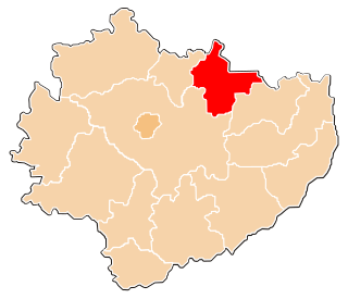
Skarżysko County is a unit of territorial administration and local government (powiat) in Świętokrzyskie Voivodeship, south-central Poland. It came into being on January 1, 1999, as a result of the Polish local government reforms passed in 1998. Its administrative seat and largest town is Skarżysko-Kamienna, which lies 34 kilometres (21 mi) north-east of the regional capital Kielce. The only other town in the county is Suchedniów, lying 10 km (6 mi) south-west of Skarżysko-Kamienna.

Gmina Brześć Kujawski is an urban-rural gmina in Włocławek County, Kuyavian-Pomeranian Voivodeship, in north-central Poland. Its seat is the town of Brześć Kujawski, which lies approximately 12 kilometres (7 mi) south-west of Włocławek and 52 km (32 mi) south of Toruń.

Gmina Frampol is an urban-rural gmina in Biłgoraj County, Lublin Voivodeship, in eastern Poland. Its seat is the town of Frampol, which lies approximately 16 kilometres (10 mi) north of Biłgoraj and 64 km (40 mi) south of the regional capital Lublin.

Gmina Bychawa is an urban-rural gmina in Lublin County, Lublin Voivodeship, in eastern Poland. Its seat is the town of Bychawa, which lies approximately 26 kilometres (16 mi) south of the regional capital Lublin.

Gmina Warta is an urban-rural gmina in Sieradz County, Łódź Voivodeship, in central Poland. Its seat is the town of Warta, which lies approximately 14 kilometres (9 mi) north-west of Sieradz and 59 km (37 mi) west of the regional capital Łódź.

Gmina Szadek is an urban-rural gmina in Zduńska Wola County, Łódź Voivodeship, in central Poland. Its seat is the town of Szadek, which lies approximately 12 kilometres (7 mi) north of Zduńska Wola and 35 km (22 mi) west of the regional capital Łódź.

Gmina Niepołomice is an urban-rural gmina in Wieliczka County, Lesser Poland Voivodeship, in southern Poland. Its seat is the town of Niepołomice, which lies approximately 12 kilometres (7 mi) north-east of Wieliczka and 21 km (13 mi) east of the regional capital Kraków.

Gmina Warka is an urban-rural gmina in Grójec County, Masovian Voivodeship, in east-central Poland. Its seat is the town of Warka, which lies approximately 25 kilometres (16 mi) east of Grójec and 50 km (31 mi) south of Warsaw.

Gmina Wieniawa is a rural gmina in Przysucha County, Masovian Voivodeship, in east-central Poland. Its seat is the village of Wieniawa, which lies approximately 13 kilometres (8 mi) east of Przysucha and 96 km (60 mi) south of Warsaw.

Gmina Jastrząb is a rural gmina in Szydłowiec County, Masovian Voivodeship, in east-central Poland. Its seat is the village of Jastrząb, which lies approximately 8 kilometres (5 mi) east of Szydłowiec and 108 km (67 mi) south of Warsaw.

Gmina Mirów is a rural gmina in Szydłowiec County, Masovian Voivodeship, in east-central Poland. Its seat is the village of Mirów, which lies approximately 13 kilometres (8 mi) south-east of Szydłowiec and 115 km (71 mi) south of Warsaw.

Gmina Mielec is a rural gmina in Mielec County, Subcarpathian Voivodeship, in south-eastern Poland. Its seat is the town of Mielec, although the town is not part of the territory of the gmina.

Gmina Skarżysko Kościelne is a rural gmina in Skarżysko County, Świętokrzyskie Voivodeship, in south-central Poland. Its seat is the village of Skarżysko Kościelne, which lies approximately 3 kilometres (2 mi) north of Skarżysko-Kamienna and 36 km (22 mi) north-east of the regional capital Kielce.

Gmina Suchedniów is an urban-rural gmina in Skarżysko County, Świętokrzyskie Voivodeship, in south-central Poland. Its seat is the town of Suchedniów, which lies approximately 10 kilometres (6 mi) south-west of Skarżysko-Kamienna and 25 km (16 mi) north-east of the regional capital Kielce.

Gmina Wąchock is an urban-rural gmina in Starachowice County, Świętokrzyskie Voivodeship, in south-central Poland. Its seat is the town of Wąchock, which lies approximately 5 kilometres (3 mi) north-west of Starachowice and 35 km (22 mi) north-east of the regional capital Kielce.

References