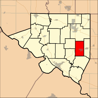
Golconda No. 2 Precinct | |
---|---|
Coordinates: 37°28′33″N088°28′49″W / 37.47583°N 88.48028°W Coordinates: 37°28′33″N088°28′49″W / 37.47583°N 88.48028°W | |
Country | United States |
State | Illinois |
County | Pope |
Area | |
• Total | 88.29 sq mi (228.66 km2) |
• Land | 87.95 sq mi (227.79 km2) |
• Water | 0.34 sq mi (0.87 km2) 0.38% |
Elevation | 548 ft (167 m) |
Population (2000) | |
• Total | 1,005 |
• Density | 11.4/sq mi (4.40/km2) |
GNIS feature ID | 1928505 [1] |
Golconda No. 2 Precinct is located in Pope County, Illinois, USA. As of the 2000 census, its population was 1,005. [2]
Pope County is a county located in the U.S. state of Illinois. According to the 2010 census, it had a population of 4,470, making it the second-least populous county in Illinois. Its county seat is Golconda. The county was organized in 1816 from portions of Gallatin and Johnson counties and named after Nathaniel Pope, a politician and jurist from the Illinois Territory and State of Illinois.
Illinois is a state in the Midwestern and Great Lakes regions of the United States. It has the fifth largest gross domestic product (GDP), the sixth largest population, and the 25th largest land area of all U.S. states. Illinois has been noted as a microcosm of the entire United States. With Chicago in northeastern Illinois, small industrial cities and immense agricultural productivity in the north and center of the state, and natural resources such as coal, timber, and petroleum in the south, Illinois has a diverse economic base, and is a major transportation hub. Chicagoland, Chicago's metropolitan area, encompasses over 65% of the state's population. The Port of Chicago connects the state to international ports via two main routes: from the Great Lakes, via the Saint Lawrence Seaway, to the Atlantic Ocean and from the Great Lakes to the Mississippi River, via the Illinois Waterway to the Illinois River. The Mississippi River, the Ohio River, and the Wabash River form parts of the boundaries of Illinois. For decades, Chicago's O'Hare International Airport has been ranked as one of the world's busiest airports. Illinois has long had a reputation as a bellwether both in social and cultural terms and, through the 1980s, in politics.
The United States of America (USA), commonly known as the United States or America, is a country comprising 50 states, a federal district, five major self-governing territories, and various possessions. At 3.8 million square miles, the United States is the world's third or fourth largest country by total area and is slightly smaller than the entire continent of Europe. With a population of over 327 million people, the U.S. is the third most populous country. The capital is Washington, D.C., and the most populous city is New York City. Most of the country is located contiguously in North America between Canada and Mexico.
Golconda No. 2 Precinct covers an area of 228.66 square kilometres (88.29 sq mi).
Bertie County is a county located in the northeast area of the U.S. state of North Carolina. As of the 2015 census, the population was 20,199. Its county seat is Windsor. The county was created in 1722 as Bertie Precinct and gained county status in 1739.
Golconda is a city in and the county seat of Pope County, Illinois, United States, located along the Ohio River. The population was 726 at the 2000 census. Most of the city is part of the Golconda Historic District.
Wabash Township is one of ten townships in Gibson County, Indiana, United States. As of the 2010 census, its population was 30 and it contained 27 housing units. Wabash Township has no organized seat within the township, as the only settlement is in two river camps Crawleyville and Jimtown. The township seat is Owensville, in Montgomery Township. This area is occasionally referred to as the "Tail of Gibson County", owing to its shape and position within the county. Nevertheless, the township is a panhandle of Gibson County, bordered by the Wabash River to the north, northwest, west, and in some parts, east, even southeast, and by Posey County to the south.
Central Precinct is located in Randolph County, Illinois, USA. As of the 2010 census, its population was 445.
Evansville Precinct is located in Randolph County, Illinois, USA. As of the 2010 census, its population was 1,015.
Palestine Precinct is located in Randolph County, Illinois, USA. As of the 2010 census, its population was 601.
Sparta Precinct is located in Randolph County, Illinois, USA. As of the 2010 census, its population was 5,387.
Steeleville Precinct is located in Randolph County, Illinois, USA. As of the 2010 census, its population was 2,668.
Walsh Precinct is located in Randolph County, Illinois, USA. As of the 2010 census, its population was 454.
Eddyville No. 6 Precinct is located in Pope County, Illinois, USA. As of the 2000 census, its population was 721.
Golconda No. 1 Precinct is located in Pope County, Illinois, USA. As of the 2000 census, its population was 708.
Golconda No. 3 Precinct is located in Pope County, Illinois, USA. Its borders are coextensive with the city of Golconda. As of the 2000 census, its population was 726.
Jefferson No. 4 Precinct is located in Pope County, Illinois, USA. As of the 2000 census, its population was 448.
Webster No. 5 Precinct is located in Pope County, Illinois, USA. As of the 2000 census, its population was 805.
Cave-In-Rock Precinct is located in Hardin County, Illinois, USA. As of the 2000 census, its population was 751.
McFarlan Precinct is located in Hardin County, Illinois, USA. As of the 2000 census, its population was 772.
Monroe Precinct is located in Hardin County, Illinois, USA. As of the 2000 census, its population was 691.
Rock Precinct is located in Hardin County, Illinois, USA. As of the 2000 census, its population was 663.
Stone Church Precinct is located in Hardin County, Illinois, USA. As of the 2000 census, its population was 640.
This Pope County, Illinois location article is a stub. You can help Wikipedia by expanding it. |