Golden Gate Cemetery (San Francisco, California)

Last updated
Golden Gate Cemetery
Former Chinese grave, Lincoln Park, San Francisco.png
Kong Chow funerary structure
Golden Gate Cemetery (San Francisco, California)
Details
EstablishedJuly 3, 1870
Closed1909
Location
Clement Street, 33rd Avenue, and 48th Avenue in San Francisco, California
CountryUnited States
Coordinates 37°47′07″N122°30′05″W / 37.7852°N 122.50138°W / 37.7852; -122.50138
TypeCity
Size200 acres (81 ha)
No. of graves29,000
Find a Grave Golden Gate Cemetery
The Political Graveyard Golden Gate Cemetery
Golden Gate Cemetery in 1876 map of San Francisco Golden Gate Cemetery in 1876 map of San Francisco.png
Golden Gate Cemetery in 1876 map of San Francisco

Golden Gate Cemetery, also called the City Cemetery, and Potter's Field, was a burial ground with 29,000 remains, active between 1870 and approximately 1909 and was located in San Francisco, California. [1] [2] The site of this former cemetery is now Lincoln Park and the Legion of Honor museum.

Contents

History

The Golden Gate Cemetery was roughly 200 acres in size, bound by Clement Street, 33rd Avenue, and 48th Avenue. [3] A large number of graves had been transferred from the earlier built Yerba Buena Cemetery to Golden Gate Cemetery with the establishment of the cemetery in 1870; some estimates place the quantity at 3000 remains. [4] [5]

Burials in the 19th-century were not always safe, and as urban graveyards such as Golden Gate Cemetery were running out of space so they had stopped using coffins, and bodies were placed directly into the sandy soil. [6] It was not uncommon to hear reports of body parts found near the cemetery or in mausoleums during this era. [6] Chinese mourners would leave food offerings for the dead at the cemetery, which in turn brought "hungry vagrants". [6] [7]

Burial population

Many of the graves were for city immigrants from Italy, Japan and France; poor and working-class people; and it featured a section as a Chinese burial ground. [8] [9] The burials were done in segregated sections of the graveyard. [6] Diverse benevolent societies, religious groups, and fraternal organizations had been granted the rights to burial here, including the Christian Chinese Society, the Qui Sen Tong Company, Improved Order of Red Men, the Slavonic Mutual Benevolent Society, the Greek Russian Slavonian Benevolent Society, German Benevolent Society, the Scandinavian Society, the French Benevolent Society, the Italian Benevolent Society, Congregation Sherith Israel, Congregation Beth Israel, Congregation Schaari Zedek, the Master Mariner's Benevolent Association, St. Andrews Society and Caledonia Club, the Hop Wo Association, the Ning Yung Association, Chuc Sen Tong Association, Ladies' Seamen's Friend Society, Società Italiana di Mutua Beneficenza, the Grand Army of the Republic, Society of Old Friends, Knights of Pythias, the Golden Gate Lodge, and the Japanese Colony of San Francisco. [3]

Notable burials included politicians Patrick Watson Tompkins and Edward Wilson McGaughey; both of whom were re-interred from Yerba Buena Cemetery. [10]

Removal of the graves

Starting in 1898, the burials stopped and by 1902, the city had banned any new burials. [11] In 1909, the Board of Supervisors turned the land over to the San Francisco Parks Commission (now known as San Francisco Recreation & Parks Department). Over the next decade some of the graves were relocated to Colma, California. However, not all graves had been properly exhumed, especially from the Chinese portion of the cemetery. [6]

Present-day

The site was replaced with Lincoln Park golf course, and the Legion of Honor museum (which opened in 1924). [2] [12] [13]

In 1993, the Legion of Honor Museum was renovating and during excavation near Lands End they discovered 700 bodies, and it is believed that there are many more still buried under the Lincoln Park Golf Course. [6] [14] Photographer Richard Barnes was hired by the Legion of Honor museum to document the building's architectural history and changes as they underwent a renovation; he was able to capture a series of images of the juxtaposition of the museum and the skeletons that were underneath, images that were later shown at Carnegie Museum of Art's Heinz Architectural Center in 2001. [14]

Some of the remaining artifact from the time of the graveyard still at Lincoln Park, include the Kong Chow funerary structure and the Ladies’ Seaman's Friend Society bronze obelisk monument. [9] [15] The Chinese inscription translated says, it is a temporary resting place for travelers from Kong Chow (present day Guangzhou) in southern China, which is referring to the Chinese tradition of returning the bones to their homeland. [9] [7]

As of 2021, there was no park or city markers or city memorials referring to the past history of the space as a cemetery, however there has been a community effort to try to add archeological landmark status. [9] [15] In October 2022, the city designated this the first archeological landmark, and added a new sign to memorize the history as a cemetery. [16]

See also

Related Research Articles

<span class="mw-page-title-main">San Francisco</span> Consolidated city-county in California, United States

San Francisco, officially the City and County of San Francisco, is the commercial, financial, and cultural center of Northern California. The city proper is the fourth most populous city in California, with 808,437 residents, and the 17th most populous city in the United States as of 2022. The city covers a land area of 46.9 square miles at the end of the San Francisco Peninsula, making it the second most densely populated large U.S. city after New York City and the fifth-most densely populated U.S. county, behind only four of the five New York City boroughs. Among the 91 U.S. cities proper with over 250,000 residents, San Francisco was ranked first by per capita income and sixth by aggregate income as of 2021. Colloquial nicknames for San Francisco include Frisco, San Fran, The City, and SF.

<span class="mw-page-title-main">Yerba Buena Island</span> Neighborhood of San Francisco, California, US

Yerba Buena Island sits in San Francisco Bay within the borders of the City and County of San Francisco. The Yerba Buena Tunnel runs through its center and connects the western and eastern spans of the San Francisco–Oakland Bay Bridge, linking the city with Oakland, California. Treasure Island is connected by a causeway to Yerba Buena Island. According to the United States Census Bureau, Yerba Buena Island and Treasure Island together have a land area of 0.901 square miles (2.33 km2) with a total population of 2,500 as of the 2010 census.

<span class="mw-page-title-main">Treasure Island, San Francisco</span> Landform and neighborhood of San Francisco in California, United States

Treasure Island is an artificial island in the San Francisco Bay and a neighborhood in the City and County of San Francisco. Built in 1936–37 for the 1939 Golden Gate International Exposition, the island was named by Clyde Milner Vandeburg, part of the Fair's public relation team. Its World's Fair site is a California Historical Landmark. Buildings there have been listed on the National Register of Historic Places, and the historical Naval Station Treasure Island, an auxiliary air facility, are designated in the Geographic Names Information System. Treasure Island is connected to Yerba Buena Island, another auxiliary island of San Francisco, by a causeway, creating access to Interstate 80.

<span class="mw-page-title-main">Sunset District, San Francisco</span> Neighborhood in San Francisco, California, United States

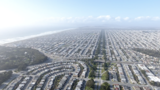
The Sunset District is a neighborhood located in the southwest quadrant of San Francisco, California, United States.

<span class="mw-page-title-main">Legion of Honor (museum)</span> Art museum in California, United States of America

The Legion of Honor, formally known as the California Palace of the Legion of Honor, is an art museum in San Francisco, California. Located in Lincoln Park, the Legion of Honor is a component of the Fine Arts Museums of San Francisco, which also administers the de Young Museum.

<span class="mw-page-title-main">Golden Gate National Cemetery</span> Veterans cemetery in San Mateo County, California

Golden Gate National Cemetery is a United States national cemetery in California, located in the city of San Bruno, 12 miles (20 km) south of San Francisco. Because of the name and location, it is frequently confused with San Francisco National Cemetery, which dates to the 19th century and is in the Presidio of San Francisco, in view of the Golden Gate. Around 1937, San Francisco residents voted to bar the opening of new cemeteries within the city proper and, as a result, the site for the new national cemetery was selected south of the city limits in adjacent San Mateo County.

<span class="mw-page-title-main">San Francisco Columbarium & Funeral Home</span> Cemetery in San Francisco, California, USA

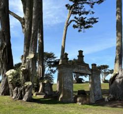
The San Francisco Columbarium & Funeral Home is a columbarium owned and operated by Dignity Memorial, located at One Loraine Court, near Stanyan and Anza Streets, just north of Golden Gate Park in San Francisco, California. Built in 1898 by architect Bernard J.S. Cahill, the copper-domed Columbarium is an example of neoclassical architecture. It is the only non-denominational burial place within San Francisco's city limits that is open to the public and has space available.
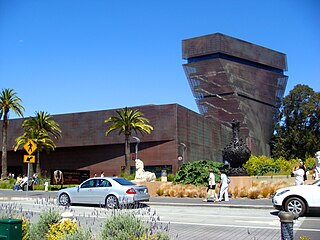
<span class="mw-page-title-main">Lincoln Park (San Francisco)</span> Park at the northwestern corner of the San Francisco Peninsula, California

Lincoln Park is a park in San Francisco, California. It was dedicated to President Abraham Lincoln in 1909 and includes about 100 acres (0.4 km2) of the northwestern corner of the San Francisco Peninsula. Lincoln Park park hosts the Legion of Honor Museum of art and is the western terminus of the Lincoln Highway, the first automobile roadway across the United States of America.

<span class="mw-page-title-main">History of San Francisco</span> History of the city San Francisco, California

The history of the city of San Francisco, California, and its development as a center of maritime trade, were shaped by its location at the entrance to a large natural harbor. San Francisco is the name of both the city and the county; the two share the same boundaries. Only lightly settled by European-Americans at first, after becoming the base for the gold rush of 1849 the city quickly became the largest and most important population, commercial, naval, and financial center in the American West. San Francisco was devastated by a great earthquake and fire in 1906 but was quickly rebuilt. The San Francisco Federal Reserve Branch opened in 1914, and the city continued to develop as a major business city throughout the first half of the 20th century. Starting in the later half of the 1960s, San Francisco became the city most famous for the hippie movement. In recent decades, San Francisco has become an important center of finance and technology. The high demand for housing, driven by its proximity to Silicon Valley, and the limited availability has led to the city being one of America's most expensive places to live. San Francisco is currently ranked 16th on the Global Financial Centres Index.

The 49-Mile Scenic Drive is a designated scenic road tour highlighting much of San Francisco, California. It was created in 1938 by the San Francisco Down Town Association to showcase the city's major attractions and natural beauty during the 1939 Golden Gate International Exposition.

<span class="mw-page-title-main">Adolph B. Spreckels</span> American businessman (1857–1924)

Adolph Bernard Spreckels was a California businessman who ran Spreckels Sugar Company and who donated the California Palace of the Legion of Honor art museum to the city of San Francisco in 1924. His wife Alma was called the "great grandmother of San Francisco". His 1912 mansion is in Pacific Heights and is San Francisco Landmark #197.

<span class="mw-page-title-main">Mount Zion Cemetery (Washington, D.C.)</span> Historic African American cemetery

Mount Zion Cemetery/Female Union Band Society Cemetery is a historic cemetery located at 27th Street NW and Mill Road NW in the Georgetown neighborhood of Washington, D.C., in the United States. The cemetery is actually two adjoining burial grounds: the Mount Zion Cemetery and Female Union Band Society Cemetery. Together these cemeteries occupy approximately three and a half acres of land. The property fronts Mill Road NW and overlooks Rock Creek Park to the rear. Mount Zion Cemetery, positioned to the East, is approximately 67,300 square feet in area; the Female Union Band Cemetery, situated to the West, contains approximately 66,500 square feet. Mount Zion Cemetery, founded in 1808 as The Old Methodist Burial Ground, was leased property later sold to Mount Zion United Methodist Church. Although the cemetery buried both White and Black persons since its inception, it served an almost exclusively African American population after 1849. In 1842, the Female Union Band Society purchased the western lot to establish a secular burying ground for African Americans. Both cemeteries were abandoned by 1950.

The following is a timeline of the history of the city of San Francisco, California, United States.

<span class="mw-page-title-main">Savannah Memorial Park</span> California historic landmark

Savannah Memorial Park Cemetery also known as El Monte Memorial Park and the Savannah Pioneer Cemetery is the oldest American non-sectarian cemetery in Southern California. The park is located in Rosemead, California, part of the park is in the neighboring city of El Monte. The park has been in continuous operation since its founding in 1850. Some of the burials may date back into the 1840s before Savannah Memorial Park became a Memorial Park. Savannah Memorial Park was designated a California Historical Landmark on March 6, 2012.

The history of the Jews in San Francisco began with the California Gold Rush in the second half of the 19th-century.

<span class="mw-page-title-main">Hills of Eternity Memorial Park</span>

Hills of Eternity Memorial Park, also known as Giboth Olam, is a Jewish cemetery founded in 1889, and is located at 1301 El Camino Real, in Colma, California. This cemetery is owned by Congregation Sherith Israel of San Francisco. It is one of four Jewish cemeteries near the city of San Francisco and it shares an adjacent space next to the Home of Peace cemetery. At Hills of Eternity Memorial Park, Jewish burials are traditionally done side-by-side, which means there is a need for larger grounds and ground maintenance.

<span class="mw-page-title-main">Japanese Cemetery (Colma, California)</span>

Japanese Cemetery was founded in 1901 and is located at 1300 Hillside Boulevard in Colma, California. This cemetery has brought together the Japanese community in California and has worked with Buddhist, Shinto, and Christian religious organizations.

<span class="mw-page-title-main">Lone Mountain Cemetery</span> Defunct cemetery in California, US

Lone Mountain Cemetery was a complex of cemeteries in the Lone Mountain neighborhood of San Francisco, California, United States on the land bounded by the present-day California Street, Geary Boulevard, Parker Avenue, and Presidio Avenue. Opened 1854, it eventually comprised Laurel Hill Cemetery, Calvary Cemetery, the Masonic Cemetery, and Odd Fellows Cemetery.

References

  1. Winegarner, Beth (2022-09-26). "The Hidden History of San Francisco's Graveyards". Alta Online. Retrieved 2022-10-24.
  2. 1 2 Meyer, Amy (2006). New Guardians for the Golden Gate: How America Got a Great National Park. University of California Press. p. 11. ISBN   978-0-520-92929-6.
  3. 1 2 "Golden Gate Cemetery O. L .R.". San Francisco Municipal Reports. San Francisco (Calif.) Board of Supervisors. order of the Board of Supervisors. 1899. p. 390.{{cite book}}: CS1 maint: others (link)
  4. Evanosky, Dennis (2013). Lost San Francisco. Pavilion. p. 344. ISBN   978-1-909815-24-7.
  5. "Alioto Piazza". SFGate . 1998-05-04. Retrieved 2022-11-02.
  6. 1 2 3 4 5 6 Chamings, Andrew; Dowd, Katie (2021-05-20). "The (actual) list of weirdest things in San Francisco". SFGate . San Francisco Chronicle. Retrieved 2022-10-31.
  7. 1 2 Kamiya, Gary; Madonna, Paul. "Point Lobos, Site of the Legion of Honor". Nob Hill Gazette. Retrieved 2022-11-02.
  8. Keraghosian, Greg (2016-10-30). "Places in San Francisco you had no idea used to be cemeteries". SFGate. Retrieved 2022-10-24.
  9. 1 2 3 4 Lee, Amber (2021-05-27). "The untold story of a Chinese cemetery in San Francisco". KTVU FOX 2. Retrieved 2022-10-25.
  10. "San Francisco City & County, Calif". The Political Graveyard. Retrieved 2022-11-03.
  11. Proctor, William A. (1950). "Location, regulation, and removal of cemeteries in the City and County of San Francisco". SFGenealogy.org. Department of City Planning, City and County of San Francisco. Retrieved 2022-10-31.
  12. Sorensen, Annelise (2010). San Francisco and Northern California. DK Eyewitness Travel. Penguin. p. 157. ISBN   978-0-7566-6153-3.
  13. "Visitor's Guide To The Legion Of Honor". CBS News. September 12, 2015. Retrieved 2022-11-02.
  14. 1 2 Lowry, Patricia (June 9, 2001). "Places: Photographer details museum's mistreatment of cemetery on which it was built". Old Post Gazette (newspaper). PG Publishing Co. Retrieved 2022-11-02.
  15. 1 2 Young, Kerri (2021-07-06). "Landmarking City Cemetery". San Francisco Heritage. Kari Lentz, John Martini, Alex Ryder. Retrieved 2022-10-31.
  16. Young, Kerri (2022-10-05). "City Cemetery Officially Designated as a City Landmark". San Francisco Heritage. Retrieved 2022-11-04.