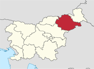
Gorica pri Šmartnem is a settlement in the City Municipality of Celje in eastern Slovenia. It lies on the eastern outskirts of the town of Celje. The area was traditionally part of the Styria region. It is now included with the rest of the municipality in the Savinja Statistical Region.
Gorica pri Raztezu is a settlement west of Brestanica in the Municipality of Krško in eastern Slovenia. The area was traditionally part of Styria. It is now included in the Lower Sava Statistical Region.
Brezje pri Oplotnici is a settlement in the Municipality of Oplotnica in eastern Slovenia. It lies in the hills between Oplotnica and Zreče. The area is part of the traditional region of Styria. The municipality is now included in the Drava Statistical Region.
Dobrova pri Prihovi is a small settlement in the Municipality of Oplotnica in eastern Slovenia. Traditionally the area was part of the Styria region. It is now included in the Drava Statistical Region.
Straža pri Oplotnici is a settlement in the Municipality of Oplotnica in eastern Slovenia. The area is part of the traditional region of Styria. The municipality is now included in the Drava Statistical Region.

Gorica pri Slivnici is a village in the Municipality of Šentjur in eastern Slovenia. The area is part of the historical region of Styria. The municipality is now included in the Savinja Statistical Region.
Dob pri Šentvidu is a village in the Municipality of Ivančna Gorica in central Slovenia. It lies east of Ivančna Gorica and the A2 motorway runs across the settlement territory to the south of the village core. The area is part of the historical region of Lower Carniola. The municipality is now included in the Central Slovenia Statistical Region.
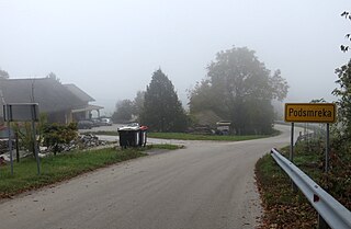
Podsmreka pri Višnji Gori is a settlement east of Višnja Gora in the Municipality of Ivančna Gorica in central Slovenia. The area is part of the historical region of Lower Carniola. The municipality is now included in the Central Slovenia Statistical Region.
Videm pri Temenici is a small settlement in the Municipality of Ivančna Gorica in central Slovenia. It lies above the valley of the Temenica River in the historical region of Lower Carniola. The municipality is now included in the Central Slovenia Statistical Region.
Breg pri Dobu is a small settlement just north of Dob pri Šentvidu in the Municipality of Ivančna Gorica in central Slovenia. The area is part of the historical region of Lower Carniola. The municipality is now included in the Central Slovenia Statistical Region.
Vrhpolje pri Šentvidu is a settlement east of Ivančna Gorica in the Lower Carniola region of Slovenia. The area is now included in the Central Slovenia Statistical Region.
Vrh pri Sobračah is a small settlement in the Municipality of Ivančna Gorica in central Slovenia. It lies just off the regional road leading through the Sava Hills from Ivančna Gorica towards Šmartno pri Litiji in the historical region of Lower Carniola. The municipality is now included in the Central Slovenia Statistical Region.
Breg pri Zagradcu is a small settlement east of Zagradec on the left bank of the Krka River in the Municipality of Ivančna Gorica in central Slovenia. The area is part of the historical region of Lower Carniola. The municipality is now included in the Central Slovenia Statistical Region.
Dečja Vas pri Zagradcu is a village on the right bank of the Krka River opposite Zagradec in the Municipality of Ivančna Gorica in central Slovenia. The area is part of the historical region of Lower Carniola. The municipality is now included in the Central Slovenia Statistical Region.

Dobrava pri Stični is a settlement northeast of Stična in the Municipality of Ivančna Gorica in central Slovenia. The area is part of the historical region of Lower Carniola. The municipality is now included in the Central Slovenia Statistical Region.
Češnjice pri Zagradcu is a settlement east of Zagradec in the Municipality of Ivančna Gorica in central Slovenia. The area is part of the historical region of Lower Carniola. The municipality is now included in the Central Slovenia Statistical Region.
Gabrovka pri Zagradcu is a village north of Zagradec in the Municipality of Ivančna Gorica in central Slovenia. The area is part of the historical region of Lower Carniola. The municipality is now included in the Central Slovenia Statistical Region.
Kamni Vrh pri Ambrusu is a small settlement on a hill north of Ambrus in the municipality of Ivančna Gorica in central Slovenia. The area is part of the historical region of Lower Carniola. The municipality is now included in the Central Slovenia Statistical Region.
Poljane pri Stični is a small settlement in the Municipality of Ivančna Gorica in central Slovenia. It lies beyond Metnaj to the north of Stična in the historical Lower Carniola region. The municipality is now included in the Central Slovenia Statistical Region.