Koritno, Oplotnica

Last updated
Koritno
Slovenia location map.svg
Red pog.svg
Koritno
Location in Slovenia
Coordinates: 46°24′4.51″N15°26′8.44″E / 46.4012528°N 15.4356778°E / 46.4012528; 15.4356778 Coordinates: 46°24′4.51″N15°26′8.44″E / 46.4012528°N 15.4356778°E / 46.4012528; 15.4356778
Country Flag of Slovenia.svg Slovenia
Traditional region Styria
Statistical region Drava
Municipality Oplotnica
Area
  Total 3.8 km2 (1.5 sq mi)
Elevation 651.3 m (2,136.8 ft)
Population (2002)
  Total 192
[1]

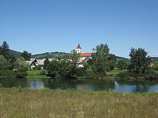
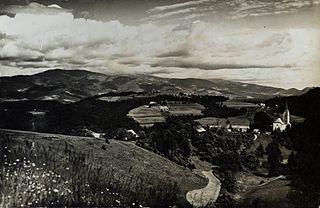
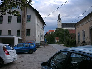
Koritno (pronounced  [kɔˈɾiːtnɔ] ) is a settlement in the Municipality of Oplotnica in eastern Slovenia. It is dispersed on the southern slopes of the Pohorje range to the north of Oplotnica. The area is part of the traditional region of Styria. The municipality is now included in the Drava Statistical Region. [2]

Oplotnica Town and Municipality in Slovenia

Oplotnica is a small town and municipality in eastern Slovenia. It lies on the Oplotniščica River, a left tributary of the Dravinja River, to the north of Slovenske Konjice. The area was part of the traditional region of Styria and formerly part of Austria-Hungary. The municipality is now included in the Drava Statistical Region.

Slovenia republic in Central Europe

Slovenia, officially the Republic of Slovenia, is a sovereign state located in southern Central Europe at a crossroads of important European cultural and trade routes. It is bordered by Italy to the west, Austria to the north, Hungary to the northeast, Croatia to the southeast, and the Adriatic Sea to the southwest. It covers 20,273 square kilometers (7,827 sq mi) and has a population of 2.07 million. One of the successor states of the former Yugoslavia, Slovenia is a parliamentary republic and a member of the United Nations, of the European Union, and of NATO. The capital and largest city is Ljubljana.

Dispersed settlement Rural settlement type, typically consists of widely spaced farmsteads without an actual nucleus

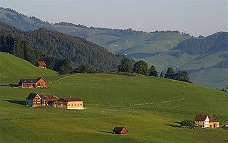
A dispersed settlement, also known as a scattered settlement, is one of the main types of settlement patterns used by landscape historians to classify rural settlements found in England and other parts of the world. Typically, there are a number of separate farmsteads scattered throughout the area. A dispersed settlement contrasts with a nucleated village.

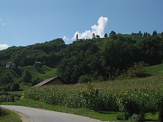
There are two churches in the settlement. The church dedicated to Saint Nicholas dates to the 14th century and belongs to the Parish of Čadram–Oplotnica. The second church is dedicated to Saint Leonard and belongs to the Kebelj parish. It dates to the early 15th century with a 17th-century belfry. [3]

Church (building) building constructed for Christian worship

A church building or church house, often simply called a church, is a building used for Christian religious activities, particularly for Christian worship services. The term is often used by Christians to refer to the physical buildings where they worship, but it is sometimes used to refer to buildings of other religions. In traditional Christian architecture, the church is often arranged in the shape of a Christian cross. When viewed from plan view the longest part of a cross is represented by the aisle and the junction of the cross is located at the altar area.

Saint Nicholas 4th-century Christian saint

Saint Nicholas of Myra, also known as Nicholas of Bari, was an early Christian bishop of the ancient Greek maritime city of Myra in Asia Minor during the time of the Roman Empire. He is revered by many Christians as a saint. Because of the many miracles attributed to his intercession, he is also known as Nicholas the Wonderworker. Saint Nicholas is the patron saint of sailors, merchants, archers, repentant thieves, children, brewers, pawnbrokers, and students in various cities and countries around Europe. His reputation evolved among the faithful, as was common for early Christian saints, and his legendary habit of secret gift-giving gave rise to the traditional model of Santa Claus through Sinterklaas.

Leonard of Noblac Frankish saint

Leonard of Noblac, is a Frankish saint closely associated with the town and abbey of Saint-Léonard-de-Noblat, in Haute-Vienne, in the Limousin (region) of France.

Related Research Articles

Vuzenica Town and Municipality in Slovenia

Vuzenica is a town and a municipality in northern Slovenia. It lies on the right bank of the Drava River and extends south into the Pohorje Hills. The area was part of the traditional region of Styria. It is now included in the Carinthia Statistical Region. Vuzenica was first mentioned as a settlement in written documents dating to 1238, but archaeological evidence points to much older settlement of the area with a Roman period burial ground in the town. Of the 13th-century castle above the settlement, only parts of the walls survive.

Šmartno ob Paki Settlement and Municipality in Slovenia

Šmartno ob Paki is a settlement and a small municipality in the lower Paka Valley in northern Slovenia. The area was part of the traditional region of Styria. It is now included in the Savinja Statistical Region.

Municipality of Straža Municipality in Slovenia

The Municipality of Straža is a municipality in southeastern Slovenia. It lies on the banks of the Krka River in the traditional region of Lower Carniola. The municipality was created in 2006 when it split from the City Municipality of Novo Mesto. It is included in the Southeast Slovenia Statistical Region. It has over 3,500 inhabitants. Its central settlement is Straža. The main employer is the Novoles company, based in the town as well as a number of smaller companies. There are many vineyards in the area.

Sele, Slovenj Gradec Place in Styria, Slovenia

Sele is a settlement in the City Municipality of Slovenj Gradec in northern Slovenia. The area was traditionally part of Styria. The entire municipality is now included in the Carinthia Statistical Region.

Drevenik Place in Styria, Slovenia

Drevenik is a settlement on the southern slopes of Mount Boč in the Municipality of Rogaška Slatina in eastern Slovenia. The area traditionally belonged to the Styria region and is now included in the Savinja Statistical Region.

Blatno, Brežice Place in Styria, Slovenia

Blatno is a settlement in the Municipality of Brežice in eastern Slovenia. The area was traditionally part of Styria. It is now included in the Lower Sava Statistical Region.

Polana, Laško Place in Styria, Slovenia

Polana is a settlement in the hills east of Zidani Most in the Municipality of Laško in eastern Slovenia. The area was traditionally part of the Styria region. It is now included with the rest of the municipality in the Savinja Statistical Region.

Strmca, Laško in Styria, Slovenia

Strmca is a settlement on the right bank of the Savinja River in the Municipality of Laško in eastern Slovenia. The area was traditionally part of the Styria region. It is now included with the rest of the municipality in the Savinja Statistical Region.

Kebelj Place in Styria, Slovenia

Kebelj is a village in the Municipality of Slovenska Bistrica in northeastern Slovenia. It lies in the Pohorje Hills, north of Oplotnica. The area is part of the traditional region of Styria. It is now included with the rest of the municipality in the Drava Statistical Region.

Dobrovlje, Braslovče in Styria, Slovenia

Dobrovlje is a dispersed settlement in the Municipality of Braslovče in northern Slovenia. It lies in the hills west of Braslovče. Traditionally the area was part of the Styria region. The municipality is now included in the Savinja Statistical Region.

Gotovlje Place in Styria, Slovenia

Gotovlje is a settlement in the Municipality of Žalec in east-central Slovenia. The A1 motorway crosses the territory of the settlement north of the village core. The area is part of the traditional region of Styria. The municipality is now included in the Savinja Statistical Region.

Brezje pri Oplotnici Place in Styria, Slovenia

Brezje pri Oplotnici is a settlement in the Municipality of Oplotnica in eastern Slovenia. It lies in the hills between Oplotnica and Zreče. The area is part of the traditional region of Styria. The municipality is now included in the Drava Statistical Region.

Čadram in Styria, Slovenia

Čadram is a settlement in the municipality of Oplotnica in eastern Slovenia. It lies immediately east of Oplotnica itself. The area is part of the traditional region of Styria. The municipality is now included in the Drava Statistical Region.

Malahorna in Styria, Slovenia

Malahorna is a village in the Municipality of Oplotnica in eastern Slovenia. The area is part of the traditional region of Styria. The municipality is now included in the Drava Statistical Region.

Prihova, Oplotnica Place in Styria, Slovenia

Prihova is a settlement in the Municipality of Oplotnica in northeastern Slovenia. The area is part of the traditional region of Styria. The municipality is now included in the Drava Statistical Region.

Spodnje Tinsko in Styria, Slovenia

Spodnje Tinsko is a village in the Municipality of Šmarje pri Jelšah in eastern Slovenia. The area is part of the historical Styria region. The municipality is now included in the Savinja Statistical Region.

Kamni Vrh pri Ambrusu in Lower Carniola, Slovenia

Kamni Vrh pri Ambrusu is a small settlement on a hill north of Ambrus in the municipality of Ivančna Gorica in central Slovenia. The area is part of the historical region of Lower Carniola. The municipality is now included in the Central Slovenia Statistical Region.

Pungert, Ivančna Gorica in Lower Carniola, Slovenia

Pungert is a small settlement in the Municipality of Ivančna Gorica in central Slovenia. The area is part of the historical region of Lower Carniola. The municipality is now included in the Central Slovenia Statistical Region.

Vranje, Sevnica in Styria, Slovenia

Vranje is a settlement in the Municipality of Sevnica in central Slovenia. It lies in the hills northeast of Sevnica in the historical region of Styria. The municipality is now included in the Lower Sava Statistical Region.

References