Gorredijk (West Frisian: De Gordyk) is the largest town in the municipality of Opsterland, in the Dutch province of Friesland. Gorredijk had a population of 7,360 in 2019.
The hamlets of Easterein and Kortezwaag are also part of the town. The latter was an independent village until 1962. Gorredijk and Kortezwaag then formed a double village as Gorredijk-Kortezwaag, but after a few years it was decided to shorten this to Gorredijk, so the older Kortezwaag became a neighborhood of Gorredijk in 1969.
History
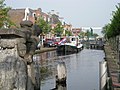
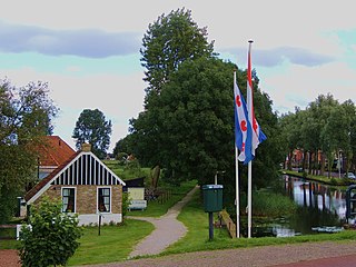
The Opsterlandse Compagnonsvaart[nl] runs through the center of Gorredijk. The town is a so-called vlecke that was created by peat extraction. In the past, Gorredijk was mainly the place where goods were imported, stored and traded.
A great amount of peat passed through Gorredijk, especially from the area behind Tijnje. There was dire poverty in the region. Jacob van Lennep says the following about it in 1823: "A little further west than the Heereveen is the Gordijcke, where there still live some half savages or cavemen, whose houses are half underground and who live from robbery and begging. Of the three criminals who are sentenced in Friesland, one is from that place."
Gorredijk used to look very different. Extensive peat bogs covered southeast Friesland. This peat was later excavated and this "industry" attracted many people to these then sparsely populated areas. The original inhabitants were farmers. They grew buckwheat, oats, rye, peas, beans, flax and herbs. They also kept sheep and bees. Cattle was kept sparingly.
The farmers in the town may have partly obtained their hay from the low countries between Tijnje and Terwispel. They will also have extracted pieces of heather in and near the Gorrevenen, which were located in the direction of present-day Jubbega. These Gorrevenen were excavated by the Heren Compagnon in the seventeenth century. Jonker Dekema in particular had many possessions here. Jonkersland (Jonkerslân) could also have been called Dekema's land.
A channel was needed to transport peat. This did not exist in 1622, but is mentioned in writing in 1630. The digging of the Hegedyk around 1631 is considered the "starting point" of the peat colony Gordijk. As there was now a channel to the Gorrevenen, the first house was built at the Hooge wech, soon followed by others. Over the hole in the dike a Hoogholtje bridge was built, underneath which the peat ships could sail with masts lowered.
Opsterlandse Compagnonsvaart
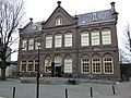
Museum Opsterlân
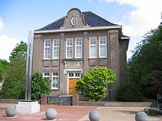
Boterwaag weigh house
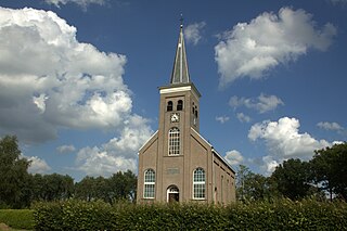
Former synagogue, 1949
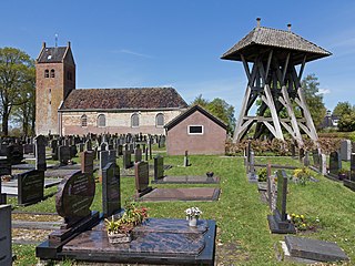
Jewish cemetery, Kortezwaag
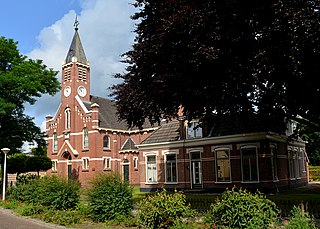
Former reformed church, April 1959
Description
Plaatselijk Belang Gorredijk
On 22 November 1880, an organization called Plaatselijk Belang (English: Local Interest) was established to aid the inhabitants of Gorredijk. For example, the local population could borrow money from the organization and Plaatselijk Belang involved itself in issues in and around town, such as the connection to the railway network of the Nederlandsche Tramweg Maatschappij[nl]. Surviving to the present, the organization remains closely involved and along with local interest groups in neighboring communities, forms a crucial dialog partner of the municipality of Opsterland. The organization periodically consults with the municipal government and informs those interested in current events via its website.[1]
Education
Gorredijk is home to three primary schools: de Treffer,[2]Loevestein,[3] and ProtestantChristian schoolde Librije.[4] Secondary education is provided by the Burgemeester Harmsma School[5] and most local students look to Heerenveen and Drachten for their tertiary education needs. Museum Opsterlân is also housed in a former school building, which was constructed in 1887 to a design by architect Jacobus Anthonie Meessen and served as a primary school until 1955.
Town center
Gorredijk is a center for retail and employment for surrounding communities. The town originated as a linear settlement along the Opsterlandse Compagnonsvaart[nl] with the most important streets being the Brouwerswal, Kerkewal, Molenwal and Langewal. The latter is crossed by the Hoofdstraat or main street. Neighborhoods such as Het Leantsje, De Helling and De Vlecke were built in the early 1970s. In the 1980s, streets such as Spinnerij, Brouwerij, Wolkammerij, Weverij, Mouterij and Kuperij were developed. The most recent construction project is the Loevestein plan, which has closed significant distance between Gorredijk and the nearby village of Lippenhuizen.
Market
From 1694 on, Gorredijk has been given the right to hold a weekly market. The former spring and autumn livestock market also dates back to those days, when cattle left or returned to the barns, respectively. The farmers then brought their butter to the weigh house at the Boterwaag and their grains to the commodity market at the Korenbeurs. Both currently serve as office buildings. As the town grew, industry kept pace. There have been three shipyards, a rope-making shop and two lime kilns in Gorredijk, though none remain at present. The former village of Kortezwaag had remained a farming community through the centuries.
Nightlife
Gorredijk had a dance hall in the 1970s, but the venue was shuttered alongside a music club on the industrial estate. Most youngsters from the town go out in Heerenveen, Drachten, Groningen or Zevenhuizen and Marum. Local pubs attract a small but regular audience. At the beginning of 1900 there were more than 100 "living room bars" in Gorredijk and the town brewed its own spirits: Gerard Brons[nl]Beerenburg and jenever. The Gerard Brons brand still exists, but is now brewed by Boomsma distillery in Leeuwarden.
During the war it was relatively quiet in Gorredijk, although there were quite a few people in the resistance in one way or another. On the eve of the liberation, there was a shooting near the draw bridge in the main street, which is now named after the fallen resistance fighter Gerke Numan. In the vicinity of the town, as elsewhere in Friesland, there were many hiding places. During the occupation, a number of Allied aircraft were shot down in the area, of which a crew of six from a BritishVickers Wellington bomber are buried in the local graveyard.
Sports and recreation
Sports clubs in Gorredijk include football association VV Gorredijk and korfball association LDODK. In addition, the town has a volleyball association Reva, rugby association De Wrotters, gymnastics association Stânfries, a tennis association, and an outdoor swimming pool.
Leeuwarden is a city and municipality in Friesland, Netherlands, with a population of 127,073 (2023). It is the provincial capital and seat of the Provincial Council of Friesland.
Opsterland is a municipality in the province of Friesland in the Netherlands.
Smallingerland is a municipality in the province of Friesland in the Netherlands.
Drachten is a town in the northern Netherlands. It is located in the municipality of Smallingerland, Friesland. It had a population of around 56.098 in 2023 and is the second largest town in the province of Friesland.
Emmeloord is the administrative centre of the municipality of Noordoostpolder, Flevoland, Netherlands. In 2019, it had a population of 26,055.
Joure is a town in the north of the Netherlands. It is the administrative center of De Fryske Marren, Friesland. With 13,090 inhabitants, it is also the most populous town in the municipality.
De Hoeve is a village in the Dutch municipality of Weststellingwerf in Friesland. It is located in an agriculture area between Wolvega and Noordwolde. De Hoeve has approximately 410 inhabitants (2017).
Bakkeveen is a village in the municipality of Opsterland in eastern Friesland (Fryslân) in the Netherlands. It had a population of around 1,465 in January 2017.
Ureterp is a village in the municipality of Opsterland in the east of Friesland, the Netherlands. After Gorredijk it is the second largest village of the municipality with a population of around 4,785 in January 2017.
Harkema is a village in the municipality of Achtkarspelen, Friesland province, the Netherlands.
De Wilp is a village in the Netherlands south of the town of Marum. It is largely located in the municipality of Westerkwartier in the province of Groningen, but a few houses of the village are in the municipality of Opsterland in the province of Friesland.
A grietenij was a municipal district, a forerunner to the gemeente or municipality in Frisia, particularly in Friesland, and also in the city Groningen which are now a part of the Netherlands. After the Saxon occupation, from about 1498 until 1851, there were a total of 30 grietenijen in Friesland and 11 cities.
Beetsterzwaag is a village in the municipality of Opsterland in the east of Friesland in the Netherlands. It had a population of around 3,485 in January 2017. Beetsterzwaag is known for its estates and manor houses.
Lippenhuizen is a village in the municipality of Opsterland in the east of Friesland, the Netherlands. It had a population of around 1,330 in January 2017.
Nij Beets is a village in the municipality of Opsterland in the east of Friesland in the Netherlands. It had a population of around 1,705 in January 2017.
Terwispel is a village in the municipality of Opsterland in the east of Friesland, the Netherlands. Its neighbouring villages are Tijnje (west), Nij Beets (north-west), Beetsterzwaag (north), Lippenhuizen (south-east), Gorredijk (South), Langezwaag (south-west) and Luxwoude. It had a population of around 1,020 in January 2017.
Noordwolde is a village in Weststellingwerf in the province of Friesland, the Netherlands. It had a population of around 3,600 as of 2017. Noordwolde-Zuid, the settlement to the south of Noordwolde is considered a separate village.
Jacobus Anthonie Meessen was a Dutch photographer who took more than 250 portraits and landscapes of the Dutch East Indies between 1864 and 1870. Born to a carpenter in Utrecht, Meessen worked in that trade in the Indies before marrying in the Netherlands in the early 1860s. He returned to the colony in 1864, intent on documenting its land and people. He worked mostly in the capital of Batavia, Java, and Padang, Sumatra; he also photographed Bangka, Belitung, Borneo, and Nias.
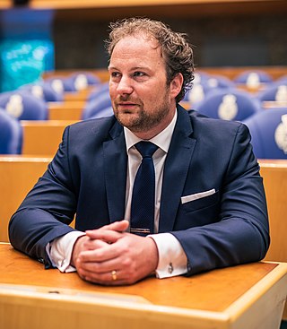
Romke Harke de Jong is a Dutch entrepreneur and politician of the social liberal party Democrats 66 (D66). He took over and expanded his father's ice cream catering company and served on the municipal council of Opsterland in Friesland between 2010 and 2018. De Jong became a member of the States of Friesland the following year, and he was elected to the House of Representatives in the 2021 general election.
Johanna "Hannie" Bruinsma-Kleijwegt was a Dutch politician. She was a member of the municipal council for Dongeradeel and the Provincial Council of Friesland. Between 1992 and 1996, she was the mayor of Zaanstad. She was a member of the Labour Party.
This page is based on this Wikipedia article Text is available under the CC BY-SA 4.0 license; additional terms may apply. Images, videos and audio are available under their respective licenses.