Terwispel | |
|---|---|
Village | |
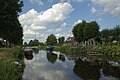
 Terwispel church | |
 Coat of arms | |
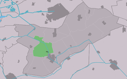 Location in Opsterland municipality | |
 Terwispel Location in the Netherlands  Terwispel Terwispel (Netherlands) | |
| Coordinates: 53°01′08″N6°2′51″E / 53.01889°N 6.04750°E | |
| Country | |
| Province | |
| Municipality | |
| Area | |
• Total | 16.55 km2 (6.39 sq mi) |
| Elevation | −0.7 m (−2.3 ft) |
| Population (2021) [1] | |
• Total | 1,000 |
| • Density | 60/km2 (160/sq mi) |
| Postal code | 8407 [1] |
| Dialing code | 0513 |
| Website | Official |
Terwispel is a village in the municipality of Opsterland in the east of Friesland, the Netherlands. Its neighbouring villages are Tijnje (west), Nij Beets (north-west), Beetsterzwaag (north), Lippenhuizen (south-east), Gorredijk (South), Langezwaag (south-west) and Luxwoude (also south-west). It had a population of around 1,020 in January 2017. [3]