Goshen Road

Last updated

Goshen Road was an early road that ran from Old Shawneetown, Illinois, on the Ohio River, northwest to the Goshen Settlement, near Glen Carbon, Illinois, near the Mississippi River. In the early 19th century, this was the main east/west road in Illinois.

Contents

History

Goshen Road started as a natural, or pioneer, trace: a route that was used by Native Americans and migrating animals. The road was not a definite, marked out path. It was, rather, a collection of vague, parallel paths that crossed, shifting with the season and over the years.

Eventually the demand for salt solidified the road's importance. "The builders of Goshen Road looked east, striving toward a place where they could obtain their necessity - salt," wrote historian Barbara Burr Hubbs. [1] Salt was one of the dearest commodities that early settlers had and one of the most difficult to obtain. Settlers at Goshen at one time bought it eagerly for $9 a barrel. Hubbs explains further:

"In the east beyond the Ohio, men looked west, striving toward new homes and better living . . . The Goshen Road funneled new residents into Illinois Territory at such a rate, its citizens became ambitious to have a state. They came by horse-drawn wagons, by two-wheeled ox-carts; they rode horses and donkeys and 'shank's mares;' they pushed wheelbarrows and carried their wealth on their backs. But they came and many stayed. Not all went the length of the road, but in 1818 when a census was taken to determine whether the Illinois population was sufficient for statehood, settlers lined the old route. It was a belt settlement from the Ohio at Shawneetown to the Mississippi at Alton . . . All across the state the generation whose fathers had traveled the Goshen Road blessed the men of Goshen who needed salt and built a road." [1]

John Reynolds, later Governor of Illinois, adds, "In the fall of 1808 a wagon road was laid off from Goshen settlement to the Ohio River salt works which in olden times was called The Goshen Road." [2] The southern stretch of the road was permanently laid out in an interesting way to find a direct route without surveying. They led a mare a day's journey away from her foal - then turned her loose. Rough blazes were cut on trees as the mare took the instinctive straightest course back to her foal. [3]

Route

Beginning around 1800, the Illinois Territory was surveyed pursuant to the Land Ordinance of 1785. Because this survey was aimed at establishing the Township and Section boundaries, the surveyors were not paid for mapping roads. However, many did show the locations of roads. Because the Goshen Road was often the only noteworthy feature at the time of the original survey, the road was noted in many of these surveys. Because these surveys marked only the Section boundaries, we often have an accurate location of the road only at one-mile (1.6 km) intervals.

Goshen Road generally followed the Saline River watershed in a northwesterly direction until it met the Big Muddy River/Saline River divide, which was also the Mississippi River/Ohio River divide. It then followed that divide in a northwesterly direction, avoiding a crossing of the swamps around the Big Muddy River. The road finally crossed the Big Muddy watershed in northern Jefferson County. The road then crossed the Kaskaskia Bottoms, which could not be avoided, on a fairly direct line toward the Goshen Settlement, in the Glen Carbon area.

Gallatin and Saline Counties

The old maps do not provide a location for the Goshen Road in Gallatin and Saline Counties. The road from Old Shawneetown to the salt works at Equality is shown, skirting the Shawnee Hills to the south of modern Illinois Route 13. Although the road probably ran from Equality toward Eldorado, there is no trace on the old maps.

Hamilton County

From the south, the original survey of Illinois first shows the Goshen Road cutting across the southwestern corner of McLeansboro Township, following the divide between two minor watersheds of the Saline River. No trace of the road remains in this area. From there, the road is shown entering Knight's Prairie.

Goshen Road ran northwesterly across Knight's Prairie Township in western Hamilton County. The route is marked by a series of modern roads that do not follow the surveyed section lines. The road ran past the modern Ten Mile Creek State Fish and Wildlife Area, appropriately named the "Goshen Trail Unit".

One of the earliest settlers in Hamilton County was William Hardisty, who recorded a land claim in Knight's Prairie, adjacent to the road, in 1819. Hardisty was living in Washington County, Kentucky as late as 1815, but held public office in Hamilton County by 1820.

In western Hamilton County, Goshen Road roughly followed the divide between the Big Muddy River and Wabash River.

Jefferson County

The earliest settler in Jefferson County was Andrew Moore, who located next to the road in 1810, near the southeast corner of the County. The Goshen Road entered the county near the southeast corner, from Hamilton County. The road exits that County as a beautifully preserved pioneer road, continuing several miles into Jefferson County as a more modern road that does not follow the Section boundaries.

The original Goshen Road turned north toward modern Opdyke, following the Big Muddy/Wabash Divide. Although the road that continues northwest toward Mt. Vernon is named "Goshen Road", it is the "Old State Highway" that was built some decades later. The original road circled around what was to become Mt. Vernon, in order to avoid the impassable swamps to the south and west of the City.

The location of the Goshen Road has been fairly well mapped across Jefferson County by Hank Lee. Signs displaying an ornate "G" have been placed along modern roads close to where the old road passed. There is some confusion in Jefferson County because the County has assigned the "Goshen Road" name to roads that were built at later dates.

As shown on the original survey of Illinois, the original Goshen Road ran straight north through the center of what eventually became the village of Opdyke, which came into existence when the east/west railroad was built through town, in the 1880s. The main north/south road today is the Section road to the west of town. All that is left of the Goshen Road is a three-block street that crosses the railroad tracks, and then goes nowhere.

From Opdyke the road ran northward toward its first difficult creek crossing: Two Mile Creek. The road was poorly mapped in this area in the original survey, and no trace seems to remain. Across the Creek, the road turned eastward somewhere near Marlow. The stretch of road running northwest near Marlow is a segment of the old Road, as mapped on the original survey.

There are traces of an old road that runs through the cemetery at Hopewell Church, near Miller Lake. The local legend identifies this as the Goshen Road. The original survey maps, however, show the road running in an east/west direction, along the line of the modern road about 1,000 feet (300 m) north of the cemetery.

From Hopewell Church, the road ran northwest toward modern Miller Lake. It crossed Casey Creek to the south of the dam. Deep wagon ruts are visible where the road climbed the bluff to the west of Casey Creek. A man-made earthen mound, 1,000 feet (300 m) long, 100 feet (30 m) wide and 50 feet (15 m) high, protrudes from the bluff just to the north of the crossing point. This may have been an ancient defensive mound built to control this crossing point.

From the Casey Creek crossing, the road ran northwest to modern Dix. Although the original survey of Illinois mapped the road in this area, few traces remain. Northwest of Dix, the road generally followed the line of what became the Southern Railway. A line of old roads parallels the tracks, a little to the north. It is not clear if any one of these is the old road, or if these roads were built after the railroad obliterated the old road when the railroad was built around 1900.

Goshen Road exited Jefferson County near Walnut Hill.

Marion County

The Goshen Road entered Marion County just to the south of Walnut Hill. It crossed the Fort Kaskaskia/Fort Vincennes Road at Walnut Hill.

The modern road that runs northwest out of Walnut Hill toward Centralia appears to be a segment of the Goshen Road, corresponding almost exactly with the road shown on the original township surveys. This road meets U.S. Route 51 just south of Centralia.

Madison County

The Goshen Settlement was located in what became Madison County.

A modern road to the south of Edwardsville is called the "Goshen Road", and is said to be a segment of the old road. This connects Illinois Route 143 with Route 159. This road is near the upper reaches of Judy's Creek. From there, the road probably followed the creek valley down to the Goshen Settlement, which was located at the base of the bluff, where Judy's Creek enters the American Bottom on its way to the Mississippi River.

Related Research Articles

Monroe County, Illinois County in Illinois

Monroe County is a county located in the U.S. state of Illinois. According to the 2010 census, it had a population of 32,957. Its county seat and largest city is Waterloo.

Jefferson County, Illinois County in Illinois

Jefferson County is a county located in the southern part of the U.S. state of Illinois. According to the 2010 census, it has a population of 38,827. The county seat is Mount Vernon.

Gallatin County, Illinois County in Illinois

Gallatin County is a county located in the U.S. state of Illinois. According to the 2010 census, it has a population of 5,589, making it the fifth-least populous county in Illinois. Its county seat is Shawneetown. It is located in the southern portion of Illinois known locally as "Little Egypt".

Mount Vernon, Illinois City in Illinois, United States

Mount Vernon is a city in and the county seat of Jefferson County, Illinois, United States. The population was 15,277 at the 2010 census.

Walnut Hill, Illinois Village in Illinois, United States

Walnut Hill is a village in Marion County, Illinois, United States. The population was 109 at the 2000 census.

U.S. Route 40 Numbered U.S. Highway in the United States

U.S. Route 40 or U.S. Highway 40 (US 40), also known as the Main Street of America, is a major east–west United States Highway traveling across the United States from the Mountain States to the Mid-Atlantic States. As with most routes whose numbers end in a zero, US 40 once traversed the entire United States. It is one of the first U.S. Highways created in 1926 and its original termini were in San Francisco, California and Atlantic City, New Jersey. In the western United States, US 40 was functionally replaced by Interstate 80 (I-80), resulting in the route being truncated multiple times. US 40 currently ends at a junction with I-80 in Silver Summit, Utah, just outside Salt Lake City.

South Yamhill River

The South Yamhill River is a tributary of the Yamhill River, approximately 60 miles (97 km) long, in northwest Oregon in the United States. It drains an area of the Northern Oregon Coast Range, as well as part of the Willamette Valley west of the Willamette River.

Opdyke, Illinois Census-designated place in Illinois, United States

Opdyke is a census-designated place in the southeastern part of Jefferson County, Illinois, United States. As of the 2010 census, its population was 254. Opdyke was laid out in 1871, following construction of the St. Louis & Southeastern Railroad. The nearby, earlier town of Lynchburg was largely abandoned and moved to Opdyke.

The Goshen Settlement was an early American pioneer settlement in what is now Illinois, USA, located to the east of St. Louis, Missouri. The settlement was located about one mile (1.6 km) southwest of modern Glen Carbon, Illinois, at the point where Judy's Creek emerges from the bluffs into the American Bottoms, on its way to the Mississippi River.

Lusk's Ferry Road was an early road in Illinois that provided an overland connection between the main settlement, Fort Kaskaskia, on the Mississippi River, and Lusk's Ferry, an important crossing point on the Ohio River. The overland route afforded an alternative to the river route, which required a difficult trip upstream on the Mississippi.

Maryland Route 17

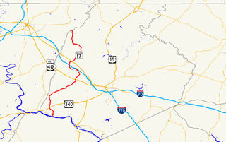
Maryland Route 17 is a state highway in the U.S. state of Maryland. The state highway begins at the Virginia state line at the Potomac River in Brunswick, where the highway continues south as Virginia State Route 287. MD 17 runs 29.49 miles (47.46 km) north from the Brunswick Bridge to the Frederick–Washington county line near Wolfsville. The state highway serves as the main north–south highway of the Middletown Valley of western Frederick County. MD 17 connects Brunswick and Wolfsville with Rosemont, Burkittsville, Middletown, and Myersville. The state highway also connects those communities with the valley's main east–west highways, which include U.S. Route 340, US 40 Alternate, Interstate 70 (I-70), and US 40.

Salt Creek is a tributary of the Little Wabash River, which it joins near Edgewood, Illinois, near the boundary between Effingham and Clay counties. There are at least two other "Salt Creeks" in Illinois: Salt Creek and Salt Creek.

Virginia State Route 39

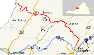
State Route 39 is a primary state highway in the U.S. state of Virginia. The state highway runs 59.17 miles (95.22 km) from the West Virginia state line near Mountain Grove, where the highway continues as West Virginia Route 39, east to U.S. Route 11 in East Lexington. SR 39 connects Lexington with several communities formed around hot springs in Bath County. In Rockbridge County, the state highway passes through the town of Goshen and Goshen Pass, a gorge formed by the Maury River.

Red Hills State Park

Red Hills State Park is an Illinois state park on 967 acres (391 ha) in Lawrence County, Illinois, United States. The park sits at an elevation of 515 feet (157 m). Red Hills State Park is open for year-round recreation including boating, fishing, hunting, hiking and various winter sports. The park includes a restaurant which is open year-round and has banquet facilities.

Stockton–Los Angeles Road, also known as the Millerton Road, Stockton–Mariposa Road, Stockton–Fort Miller Road or the Stockton–Visalia Road, was established about 1853 following the discovery of gold on the Kern River in Old Tulare County. This route between Stockton and Los Angeles followed by the Stockton–Los Angeles Road is described in "ITINERARY XXI. From Fort Yuma to Benicia, California", in The Prairie Traveler: A Hand-book for Overland Expeditions by Randolph Barnes Marcy. The Itinerary was derived from the report of Lieutenant R. S. Williamson on his topographical survey party in 1853, that was in search of a railroad route through the interior of California.

Juab Valley

The Juab Valley is a 40-mile (64 km) long valley located on the eastern edge of Juab County, Utah, United States.

Salt Creek (Middle Fork Willamette River tributary)

Salt Creek is a tributary, 30 miles (48 km) long, of the Middle Fork Willamette River in Lane County in the U.S. state of Oregon. It is named for salt springs along its banks that are used as licks by deer. The stream originates as an outflow of Lower Betty Lake in the forested Cascade Range just southeast of Waldo Lake. From its source, Salt Creek flows generally south, through Gold Lake, to Route 58, which it then follows mainly northwest for about 26 miles (42 km) to its mouth at the Middle Fork Willamette River just below Hills Creek Dam. At Salt Creek Falls—roughly 4 miles (6.4 km) west of Willamette Pass and a little more than 22 miles (35 km) upstream from the mouth—the stream plunges 286 feet (87 m), discharging an average of 50,000 U.S. gallons (190,000 L) of water per minute, or 111 cubic feet per second (3.1 m3/s). Below the falls, the creek enters a narrow canyon shaped by glaciation and basalt lava flows from higher in the Cascades. McCredie Hot Springs, at the former community of McCredie Springs, are natural hot springs along the lower half of Salt Creek beside Route 58.

Mormon Road, also known to the 49ers as the Southern Route, of the California Trail, was a seasonal wagon road first pioneered by a Mormon party from Salt Lake City, Utah led by Jefferson Hunt, that followed the route of Spanish explorers and the Old Spanish Trail across southwestern Utah, northwestern Arizona, southern Nevada and the Mojave Desert of California to Los Angeles in 1847. From 1855, it became a military and commercial wagon route between California and Utah, called the Los Angeles - Salt Lake Road. In later decades this route was variously called the "Old Mormon Road", the "Old Southern Road", or the "Immigrant Road" in California. In Utah, Arizona and Nevada it was known as the "California Road".

Canajoharie Creek

The Canajoharie Creek is a river that flows into the Mohawk River in the Village of Canajoharie in the U.S. State of New York. The name "Canajoharie" is a Mohawk language term meaning "the pot that washes itself", referring to the "Canajoharie Boiling Pot", a 20-foot (6.1 m) wide and 10-foot (3.0 m) deep pothole in the Canajoharie Creek, just south of the village of Canajoharie. Bowmans Creek is one main tributary that enters the creek east of the Hamlet of Sprout Brook. The other main tributary is Brimstone Creek which enters the creek north-northwest of the Village of Ames.

Currant Creek (Juab and Utah counties, Utah)

Currant Creek is a stream in eastern Juab County and southern Utah County in northern Utah, United States.

References

  1. 1 2 Egyptian Key, 1949 (a bi-monthly publication from 1943-1950).
  2. Reynolds, John. The Pioneer History of Illinois. 2nd ed. (Chicago: Fergus Printing Company, 1887).
  3. Claybourn, Verner M., and Harriette Pinnell Threlkeld. The Claybourn Family (A-1 Business Service, 1959).