Gostolin | |
|---|---|
Village | |
| Country | |
| Voivodeship | Masovian |
| County | Płońsk |
| Gmina | Załuski |
Gostolin [ɡɔsˈtɔlin] is a village in the administrative district of Gmina Załuski, within Płońsk County, Masovian Voivodeship, in east-central Poland. [1]
Gostolin | |
|---|---|
Village | |
| Country | |
| Voivodeship | Masovian |
| County | Płońsk |
| Gmina | Załuski |
Gostolin [ɡɔsˈtɔlin] is a village in the administrative district of Gmina Załuski, within Płońsk County, Masovian Voivodeship, in east-central Poland. [1]

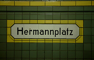
Hermannplatz is a station in the Neukölln district of Berlin which serves as an interchange between the lines
Ławy Drwęczne is a village in the administrative district of Gmina Zbiczno, within Brodnica County, Kuyavian-Pomeranian Voivodeship, in north-central Poland.
Piła-Młyn is a village in the administrative district of Gmina Cekcyn, within Tuchola County, Kuyavian-Pomeranian Voivodeship, in north-central Poland.
Flantrowo is a village in the administrative district of Gmina Janowiec Wielkopolski, within Żnin County, Kuyavian-Pomeranian Voivodeship, in north-central Poland.
Wiktorowo is a village in the administrative district of Gmina Perlejewo, within Siemiatycze County, Podlaskie Voivodeship, in north-eastern Poland.

Kolonia Kociszew is a village in the administrative district of Gmina Zelów, within Bełchatów County, Łódź Voivodeship, in central Poland. It lies approximately 6 kilometres (4 mi) north-east of Zelów, 15 km (9 mi) north of Bełchatów, and 36 km (22 mi) south of the regional capital Łódź.

Fərraş is a village in the Lachin Rayon of Azerbaijan.

Janów is a village in the administrative district of Gmina Zgierz, within Zgierz County, Łódź Voivodeship, in central Poland. It lies approximately 6 kilometres (4 mi) north-east of Zgierz and 10 km (6 mi) north of the regional capital Łódź.
Świątniki is a village in the administrative district of Gmina Wodzisław, within Jędrzejów County, Świętokrzyskie Voivodeship, in south-central Poland.

Lelusin is a village in the administrative district of Gmina Chęciny, within Kielce County, Świętokrzyskie Voivodeship, in south-central Poland. It lies approximately 9 kilometres (6 mi) south of Chęciny and 19 km (12 mi) south-west of the regional capital Kielce.
Białe is a village in the administrative district of Gmina Gostynin, within Gostynin County, Masovian Voivodeship, in east-central Poland.
Olszewo-Chlebowo is a settlement in the administrative district of Gmina Stupsk, within Mława County, Masovian Voivodeship, in east-central Poland.

Barcikowo is a village in the administrative district of Gmina Słupno, within Płock County, Masovian Voivodeship, in east-central Poland. It lies approximately 14 kilometres (9 mi) east of Płock and 82 km (51 mi) north-west of Warsaw.

Ludwików is a village in the administrative district of Gmina Jedlińsk, within Radom County, Masovian Voivodeship, in east-central Poland.
Stare Trębice is a village in the administrative district of Gmina Paprotnia, within Siedlce County, Masovian Voivodeship, in east-central Poland.
Okalewo is a former village in the administrative district of Gmina Suchy Las, within Poznań County, Greater Poland Voivodeship, in west-central Poland.

Bagatelka is a village in the administrative district of Gmina Miłosław, within Września County, Greater Poland Voivodeship, in west-central Poland.
Lubogóra is a village in the administrative district of Gmina Świebodzin, within Świebodzin County, Lubusz Voivodeship, in western Poland.
Vaigu-Rannaküla is a village in Saaremaa Parish, Saare County in western Estonia.

Al-Qubeir is a settlement in the Hama Governorate of Syria, near the larger village of Maarzaf. Al-Qubeir is described as a Sunni farming enclave surrounded by Alawite villages in the central province of Hama.
Coordinates: 52°29′14″N20°30′54″E / 52.48722°N 20.51500°E
| This Płońsk County location article is a stub. You can help Wikipedia by expanding it. |