
Friedrich Wilhelm Bessel was a German astronomer, mathematician, physicist and geodesist. He was the first astronomer who determined reliable values for the distance from the sun to another star by the method of parallax. A special type of mathematical functions were named Bessel functions after Bessel's death, though they had originally been discovered by Daniel Bernoulli and then generalised by Bessel.

Geodesy is the Earth science of accurately measuring and understanding Earth's geometric shape, orientation in space and gravitational field. The field also incorporates studies of how these properties change over time and equivalent measurements for other planets. Geodynamical phenomena include crustal motion, tides and polar motion, which can be studied by designing global and national control networks, applying space and terrestrial techniques and relying on datums and coordinate systems.

In geography, latitude is a geographic coordinate that specifies the north–south position of a point on the Earth's surface. Latitude is an angle which ranges from 0° at the Equator to 90° at the poles. Lines of constant latitude, or parallels, run east–west as circles parallel to the equator. Latitude is used together with longitude to specify the precise location of features on the surface of the Earth. On its own, the term latitude should be taken to be the geodetic latitude as defined below. Briefly, geodetic latitude at a point is the angle formed by the vector perpendicular to the ellipsoidal surface from that point, and the equatorial plane. Also defined are six auxiliary latitudes which are used in special applications.
Longitude, is a geographic coordinate that specifies the east–west position of a point on the Earth's surface, or the surface of a celestial body. It is an angular measurement, usually expressed in degrees and denoted by the Greek letter lambda (λ). Meridians connect points with the same longitude. By convention, one of these, the Prime Meridian, which passes through the Royal Observatory, Greenwich, England, was allocated the position of 0° longitude. The longitude of other places is measured as the angle east or west from the Prime Meridian, ranging from 0° at the Prime Meridian to +180° eastward and −180° westward. Specifically, it is the angle between a plane through the Prime Meridian and a plane through both poles and the location in question.
The metre or meter is the base unit of length in the International System of Units (SI). The SI unit symbol is m. The metre is defined as the length of the path travelled by light in a vacuum in 1/299 792 458 of a second. The metre was originally defined in 1793 as one ten-millionth of the distance from the equator to the North Pole along a great circle, so the Earth's circumference is approximately 40000 km. In 1799, the metre was redefined in terms of a prototype metre bar. In 1960, the metre was redefined in terms of a certain number of wavelengths of a certain emission line of krypton-86. In 1983, the current definition was adopted.

A geographic coordinate system is a coordinate system that enables every location on Earth to be specified by a set of numbers, letters or symbols. The coordinates are often chosen such that one of the numbers represents a vertical position and two or three of the numbers represent a horizontal position; alternatively, a geographic position may be expressed in a combined three-dimensional Cartesian vector. A common choice of coordinates is latitude, longitude and elevation. To specify a location on a plane requires a map projection.

Earth radius is the distance from the center of Earth to a point on its surface. Its value ranges from 6,378 km (3,963 mi) at the equator to 6,357 km (3,950 mi) at a pole. A nominal Earth radius is sometimes used as a unit of measurement in astronomy and geophysics, denoted in astronomy by the symbol R⊕. In other contexts, it is denoted or sometimes .

Friedrich Georg Wilhelm von Struve was a German-Russian astronomer and geodesist from the famous Struve family. He is best known for studying double stars and for initiating a triangulation survey later named Struve Geodetic Arc in his honor.
The World Geodetic System (WGS) is a standard for use in cartography, geodesy, and satellite navigation including GPS. This standard includes the definition of the coordinate system's fundamental and derived constants, the ellipsoidal (normal) Earth Gravitational Model (EGM), a description of the associated World Magnetic Model (WMM), and a current list of local datum transformations.
Geodesy (/dʒiːˈɒdɨsi/), also named geodetics, is the scientific discipline that deals with the measurement and representation of the Earth. The history of geodesy began in pre-scientific antiquity and blossomed during the Age of Enlightenment.
Figure of the Earth is a term of art in geodesy that refers to the size and shape used to model Earth. The size and shape it refers to depend on context, including the precision needed for the model. The sphere is an approximation of the figure of the Earth that is satisfactory for many purposes. Several models with greater accuracy have been developed so that coordinate systems can serve the precise needs of navigation, surveying, cadastre, land use, and various other concerns.
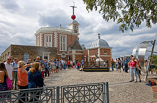
The future prime meridian based at the Royal Observatory, Greenwich, in London, England, was established by Sir George Airy in 1851. By 1884, over two-thirds of all ships and tonnage used it as the reference meridian on their charts and maps. In October of that year, at the behest of US President Chester A. Arthur, 41 delegates from 25 nations met in Washington, D.C., United States, for the International Meridian Conference. This conference selected the meridian passing through Greenwich as the official prime meridian due to its popularity. However, France abstained from the vote, and French maps continued to use the Paris meridian for several decades. In the 18th century, London lexicographer Malachy Postlethwayt published his African maps showing the "Meridian of London" intersecting the Equator a few degrees west of the later meridian and Accra, Ghana.

In geodesy, a reference ellipsoid is a mathematically defined surface that approximates the geoid, the truer figure of the Earth, or other planetary body. Because of their relative simplicity, reference ellipsoids are used as a preferred surface on which geodetic network computations are performed and point coordinates such as latitude, longitude, and elevation are defined.
The Geodetic Reference System 1980 is a geodetic reference system consisting of a global reference ellipsoid and a gravity field model.

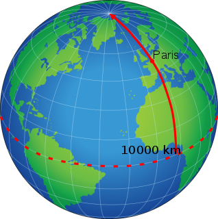
The Paris meridian is a meridian line running through the Paris Observatory in Paris, France – now longitude 2°20′14.03″ East. It was a long-standing rival to the Greenwich meridian as the prime meridian of the world. The "Paris meridian arc" or "French meridian arc" is the name of the meridian arc measured along the Paris meridian.
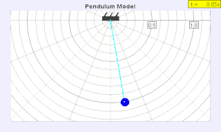
A seconds pendulum is a pendulum whose period is precisely two seconds; one second for a swing in one direction and one second for the return swing, a frequency of 1/2 Hz. A pendulum is a weight suspended from a pivot so that it can swing freely. When a pendulum is displaced sideways from its resting equilibrium position, it is subject to a restoring force due to gravity that will accelerate it back toward the equilibrium position. When released, the restoring force combined with the pendulum's mass causes it to oscillate about the equilibrium position, swinging back and forth. The time for one complete cycle, a left swing and a right swing, is called the period. The period depends on the length of the pendulum, and also to a slight degree on its weight distribution and the amplitude (width) of the pendulum's swing.
In geodesy, a meridian arc measurement is the distance between two points with the same longitude, i.e., a segment of a meridian curve or its length. Two or more such determinations at different locations then specify the shape of the reference ellipsoid which best approximates the shape of the geoid. This process is called the determination of the figure of the Earth. The earliest determinations of the size of a spherical Earth required a single arc. The latest determinations use astro-geodetic measurements and the methods of satellite geodesy to determine the reference ellipsoids.
The Bessel ellipsoid is an important reference ellipsoid of geodesy. It is currently used by several countries for their national geodetic surveys, but will be replaced in the next decades by modern ellipsoids of satellite geodesy.
An Earth ellipsoid is a mathematical figure approximating the Earth's form, used as a reference frame for computations in geodesy, astronomy, and the geosciences. Various different ellipsoids have been used as approximations.
The history of the metre starts with the scientific revolution that began with Nicolaus Copernicus's work in 1543. Increasingly accurate measurements were required, and scientists looked for measures that were universal and could be based on natural phenomena rather than royal decree or physical prototypes. Rather than the various complex systems of subdivision in use, they also preferred a decimal system to ease their calculations.