
Snowdon, or Yr Wyddfa, is a mountain in the Snowdonia region of North Wales. It has an elevation of 1,085 metres (3,560 ft) above sea level, which makes it both the highest mountain in Wales and the highest in the British Isles south of the Scottish Highlands. Snowdon is designated a national nature reserve for its rare flora and fauna, and is located within Snowdonia National Park.

The Glyderau are a mountain group in Snowdonia, North Wales. The name derives from the highest peaks in the range, Glyder Fawr and Glyder Fach. According to Sir Ifor Williams, the word "Glyder" derives from the Welsh word "Cludair", meaning a heap of stones.

Cadair Idris or Cader Idris is a mountain in the Meirionnydd area of Gwynedd, Wales. It lies at the southern end of the Snowdonia National Park near the town of Dolgellau. The peak, which is one of the most popular in Wales for walkers and hikers, is composed largely of Ordovician igneous rocks, with classic glacial erosion features such as cwms, moraines, striated rocks, and roches moutonnées.

Moel Hebog is a mountain in Snowdonia, north Wales which dominates the view west from the village of Beddgelert. It gives name to a whole range of peaks in the north-western corner of Snowdonia, which include the Nantlle Ridge and Mynydd Mawr.

Cadair Berwyn, Cader Berwyn or Craig Uchaf is a mountain summit in north-east Wales with a height of 832 metres (2,730 ft) above sea level. It is the highest point in the Berwyn range, the highest in North East Wales and the highest significant summit in Wales outside the National Parks. Cadair Berwyn and Foel Cedig to the west are the two Marilyns that form the Berwyn range. The undulating plateau of the range also includes a large number of other summits above 2,000 feet (610 m), including satellite summits of Cadair Berwyn and many which are classed as Nuttalls.

Y Rhiw is a small village on the south west tip of the Llŷn Peninsula in Gwynedd, Wales. The village forms part of the community of Aberdaron.

Yr Eifl, sometimes called the Rivals in English, is a group of hills on the north coast of the Llŷn Peninsula in Gwynedd, Wales.
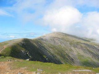
Carnedd Dafydd is a mountain peak in the Carneddau range in Snowdonia, Wales, and is the third highest peak in Wales, or the fourth if Crib y Ddysgl on the Snowdon ridge is counted. Situated south-west of Carnedd Llewelyn and north of Pen yr Ole Wen, Carnedd Dafydd is on the main ridge of the Carneddau, and on the border between Gwynedd and Conwy. The average annual temperature of the mountain is around 3–4 °C (38–40 °F).

Tal-y-llyn Lake,, also known as Talyllyn Lake and Llyn Myngul, is a large glacial ribbon lake in Gwynedd, North Wales. It is formed by a post-glacial massive landslip damming up the lake within the glaciated valley. The hamlet of Talyllyn lies at the west end of the lake.

Mynydd Graig Goch is the western end peak of the Nantlle Ridge, and is a subsidiary summit of Craig Cwm Silyn. It is also the most westerly 2000 ft peak in Wales. For many years it was excluded from lists of the Welsh 2000 ft mountains because of a spot height of 609 metres (1998') on OS maps. However, this changed in 2008; after years of speculation a group of hillwalkers carried out a precise GPS survey of the peak, measuring the absolute height as 609.75 metres.

Waun Lefrith is a top of Picws Du and is also the westernmost of the Carmarthen Fans, a group of peaks within the Black Mountain of the Brecon Beacons National Park. It lies within Carmarthenshire, Wales. The summit plateau of the mountain reaches a height of 2221 feet above sea level. Picws Du and Fan Foel are the other, higher summits of the Carmarthen Fans. The glacial lake of Llyn y Fan Fach dominates the panorama to the north of the peak. Beyond the lake to the north lies the Usk Reservoir and then the Cambrian Mountains on the horizon. Swansea Bay and the Bristol Channel are visible to the south across the undulating dip slope of the mountain. The Towy (Tywi) valley lies to the west, with Llandovery and Llandeilo as important market towns nearest to the hills.

Picws Du is the second highest peak of the Carmarthen Fans in the Carmarthenshire section of the Black Mountain in the west of the Brecon Beacons National Park in south Wales. The highest peak is Fan Foel immediately next along the ridge and it is a subsidiary summit of Fan Brycheiniog. Picws Du falls within Fforest Fawr Geopark and its prominent summit is marked by a large Bronze Age round barrow at a height of 2457 feet above sea level. Waun Lefrith is the other, lower summit of the Bannau Sir Gâr / Carmarthen Fans situated to the west. The peak overlooks the glacial lake of Llyn y Fan Fach in the cwm below. As the peak sits on the edge of the escarpment on a ridge which juts out into the valley below, the views from the summit are panoramic and extensive. The views to the north are especially impressive when the weather is clear, looking towards the Cambrian Mountains, Mynydd Epynt and Brecon. Swansea and the Bristol Channel can just be seen on the horizon to the south, across the gently falling dip slope. Pen y Fan and Corn Du are distinctive landmarks seen directly to the east across Fforest Fawr.
Mynydd Bach Trecastell is a hill on the border between the counties of Carmarthenshire and Powys in southwest Wales. It lies within the Black Mountain range of the Brecon Beacons National Park and Fforest Fawr Geopark. Its summit is plateau-like and reaches a height of 412m at OS grid ref SN 827312 at Y Pigwn. The name signifies the 'little hill of castle town'.

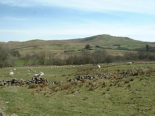
Mynydd Carn-y-cefn is the name given to the broad ridge of high ground between the Ebbw Vale and the valley of the Ebbw Fach in the Valleys region of South Wales. It lies within the county borough of Blaenau Gwent, formerly Monmouthshire.
Cefn Manmoel is the name given to the broad ridge of high ground between the Sirhowy Valley and Ebbw Vale in the Valleys region of South Wales. It straddles the boundary between the unitary areas of Caerphilly and Blaenau Gwent.

Mynydd Cilfach-yr-encil attains a height of 445m at OS grid reference SO 079033 making it the high point of the broad ridge of high ground between Taff Vale and Cwm Bargod in the Valleys region of South Wales. It lies within the County Borough of Merthyr Tydfil.
Cefn y Brithdir is the name given to the broad ridge of high ground between the Rhymney Valley and Cwm Darran in the Valleys region of South Wales. It lies within the County Borough of Caerphilly.

Moel Emoel is a hill within the Snowdonia National Park in Gwynedd, North Wales.
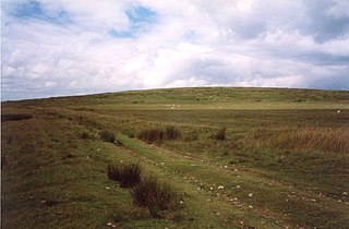
Moel Oernant is a 503-metre (1,650 ft) high hill in the community of Trawsfynydd in the county of Gwynedd in North Wales. It has a number of western tops, the highest of which reaches a height of 466 metres (1,529 ft) overlooking the waterbody known as Llyn Gelli-Gain and another at Frîdd Wen exceeds 410 metres (1,350 ft). To the south of the lake is the top of Pîg Idris which reaches 429m. The minor top of Y-Foel attains 430m to the northeast of Moel Oernant.
