
K2, at 8,611 metres (28,251 ft) above sea level, is the second-highest mountain on Earth, after Mount Everest at 8,849 metres (29,032 ft). It lies in the Karakoram range, partially in the Gilgit-Baltistan region of Pakistan-administered Kashmir and partially in the China-administered Trans-Karakoram Tract in the Taxkorgan Tajik Autonomous County of Xinjiang.

Lhotse is the fourth-highest mountain on Earth, after Mount Everest, K2, and Kangchenjunga. At an elevation of 8,516 metres (27,940 ft) above sea level, the main summit is on the border between Tibet Autonomous Region of China and the Khumbu region of Nepal.

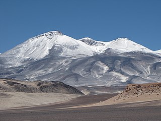
The eight-thousanders are the 14 mountains recognised by the International Mountaineering and Climbing Federation (UIAA) as being more than 8,000 metres (26,247 ft) in height above sea level, and sufficiently independent of neighbouring peaks. There is no precise definition of the criteria used to assess independence, and at times, the UIAA has considered whether the list should be expanded to 20 mountain peaks by including the major satellite peaks of eight-thousanders. All of the eight-thousanders are located in the Himalayan and Karakoram mountain ranges in Asia, and their summits lie in an altitude known as the death zone.

Dhaulagiri, located in Nepal, is the seventh highest mountain in the world at 8,167 metres (26,795 ft) above sea level, and the highest mountain within the borders of a single country. It was first climbed on 13 May 1960 by a Swiss-Austrian-Nepali expedition. Annapurna I is 34 km (21 mi) east of Dhaulagiri. The Kali Gandaki River flows between the two in the Kaligandaki Gorge, said to be the world's deepest. The town of Pokhara is south of the Annapurnas, an important regional center and the gateway for climbers and trekkers visiting both ranges as well as a tourist destination in its own right.
Peak bagging or hill bagging is an activity in which hikers, climbers, and mountaineers attempt to reach a collection of summits, published in the form of a list. This activity has been popularized around the world, with lists such as 100 Peaks of Taiwan, four-thousand footers, 100 Famous Japanese Mountains, the Sacred Mountains of China, the Seven Summits, the Fourteeners of Colorado, and the eight-thousanders becoming the subject of mass public interest.

Józef Jerzy Kukuczka was a Polish mountaineer. He was born in Katowice, his family was ethnically Silesian Goral. On 18 September 1987, he became the second man to climb all fourteen eight-thousanders in the world; a feat which took him less than 8 years to accomplish. He is the only person to have climbed two eight-thousanders in one winter. Altogether, he ascended four eight-thousanders in winter, including three as first ascents. Along with Tadeusz Piotrowski, Kukuczka established a new route on K2 in alpine style, which no one has repeated.

Wildcat Mountain is a mountain located in Coos County, northern New Hampshire, United States. The mountain is part of the Carter-Moriah Range of the White Mountains, on the east side of Pinkham Notch. Wildcat Mountain faces Carter Dome across Carter Notch to the northeast, and Mount Washington across Pinkham Notch to the west.

Mont Blanc de Courmayeur is a point on the south-east ridge of Mont Blanc that forms the peak of the massive south-east face of the mountain. It is connected to the main summit via the Col Major.
Picco Muzio is a minor summit below the Matterhorn on the Furggen ridge. Because of its prominence on that ridge, it was included in the 'enlarged list' of alpine four-thousanders.

La Spedla is a minor summit south of Piz Bernina on the border between Italy and Switzerland. With a height of 4,020 metres above sea level, it is the highest summit on the Italian side of the Bernina Range and the highest summit in Lombardy. Because of its small prominence it was included only in the enlarged list of alpine four-thousanders.

The High Alps are the parts of the Alps unsuitable for habitation or seasonal transhumance. This includes all regions higher than 3,000 m above sea level, as well as most regions between 2,500 m and 3,000 m. Alpine pastures are typically below 2,400 m but may exceptionally be located as high as 2,800 m.
Pic Eccles is a mountain in the Mont Blanc massif in the Aosta Valley, Italy. It lies at the foot of the Innominata ridge to the summit of Mont Blanc. The mountain is named after the English mountaineer and geologist James Eccles.

The Alpine Club classification of the Eastern Alps is a common division of the Eastern Alps into 75 mountain ranges, based on the Moriggl Classification (ME) first published in 1924 by the German and Austrian Alpine Club. The present-day division established for the German-speaking world was compiled by the German, Austrian and South Tyrol Alpine Clubs and published in 1984 and is also used for the basic numbering of Alpine Club maps for mountaineering.

A four-thousander is a mountain summit that is at least 4,000 metres above sea level. The term is popular among European mountaineers and climbers because the highest peaks in Europe fall into this category, and the summits of four-thousanders are popular in Europe as climbing goals. Although climbing these peaks does not require an expedition to be mounted, knowledge and experience of high altitude climbing is a pre-requisite for attempting these peaks.
Three-thousanders are mountains with a height of between 3,000 metres (9,800 ft), but less than 4,000 metres (13,000 ft) above sea level. Similar terms are commonly used for mountains of other height brackets e. g. four-thousanders or eight-thousanders. In Britain, the term may refer to mountains above 3,000 feet (910 m).

