
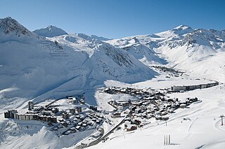
Val d'Isère is a commune of the Tarentaise Valley, in the Savoie department in southeastern France. It lies 5 km (3 mi) from the border with Italy. It is on the border of the Vanoise National Park created in 1963. During the Albertville 1992 Winter Olympics, the Face de Bellevarde was the site of the men's downhill race. Other alpine skiing events held during those games included men's giant slalom and alpine combined. Val d'Isère regularly hosts World Cup alpine events, usually for the men in early December, and hosted the World Championships in 2009. It is located in the Savoie région with good transport links in and out of Lyon, Geneva and Chambéry. The ski area of Val d'Isère and Tignes forms the Espace Killy, named after the triple Olympic champion Jean-Claude Killy who grew up in Val d'Isère. There are two mountain huts owned by the Vanoise National Park on the territory of Val d’Isère: le Refuge du Prariond and le Refuge du Fond des Fours.
La Fourche is a station of the Paris Métro, serving Line 13.

The Diablerets are a huge ice-covered mountain massif of the Alps, culminating at the Sommet des Diablerets at 3,210 metres (10,530 ft) above sea level and straddling the border between the Swiss cantons of Vaud (VD) and Valais (VS). The northeastern part of the massif stretches also into the canton of Bern (BE).

The Battle of Bayou Fourche, also known as the Battle of Little Rock and the Engagement at Bayou Fourche, took place on September 10, 1863, in Pulaski County, Arkansas, and was the final battle of the Little Rock Campaign, also known as the Advance upon Little Rock, which began on August 1 to capture the capital. Union Major-General Frederick Steele's "Arkansas expedition," 15,000 strong, defeated Confederate Major-General Sterling Price's 7,749 District of Arkansas. The Confederate forces took up defensive positions in and around the city of Little Rock. The area of the battle was bisected by the Arkansas River, with the Bayou Fourche forming an additional obstacle to the south-east of Little Rock. Steele divided his army into two main sections in order to attack from both the east and south-east. There was fierce fighting at river crossing points and, following the crossing of the Bayou Fourche to the east of the city, the "Arkansas expedition" entered Little Rock and organized Confederate resistance collapsed. Price's army was able to escape capture.

The Haute Route, is the name given to a route undertaken on foot or by ski touring between the Mont Blanc in Chamonix, France, and the Matterhorn, in Zermatt, Switzerland.

A cirque is an amphitheatre-like valley formed by glacial erosion. Alternative names for this landform are corrie and cwm. A cirque may also be a similarly shaped landform arising from fluvial erosion.

The mountains of the Massif des Écrins form the core of the Écrins National Park in France.
Tignes is a commune in the Tarentaise Valley, in the Savoie department in the Rhône-Alpes region in south-eastern France, known for the highest skiable area in Europe and the longest ski season in Europe. It is located in the Savoie region with good transport links in and out of Lyon, Geneva and Chambéry.
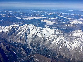
The Mont Blanc massif is a mountain range in the Alps, located mostly in France and Italy, but also straddling Switzerland at its northeastern end. It contains eleven major independent summits, each over 4,000 metres (13,123 ft) in height. It is named after Mont Blanc, the highest point in western Europe and the European Union. Because of its considerable overall altitude, a large proportion of the massif is covered by glaciers, which include the Mer de Glace and the Miage Glacier – the longest glaciers in France and Italy, respectively.

The Athabasca Glacier is one of the six principal 'toes' of the Columbia Icefield, located in the Canadian Rockies. The glacier currently loses depth at a rate of about 5 metres (16 ft) per year and has receded more than 1.5 km (0.93 mi) and lost over half of its volume in the past 125 years. Easily accessible, it is the most visited glacier in North America. The leading edge of the glacier is within easy walking distance; however, travel onto the glacier is not recommended unless properly equipped. Hidden crevasses have led to the deaths of unprepared tourists.

The canton of Provins is a French administrative division, located in the arrondissement of Provins, in the Seine-et-Marne département.

The Rallier du Baty Peninsula is a peninsula of Grande Terre, the main island of the subantarctic Kerguelen archipelago in the southern Indian Ocean. It occupies the south-western corner of the island, and is about 35 km long, extending from north to south, and 25 km across at its widest. The 1,202 m high Bicorne rises in the southern coast of the peninsula. It is named for Raymond Rallier du Baty, a French sailor who charted the archipelago in the early 20th century. The Îles Boynes, France's southernmost land apart from Adélie Land in Antarctica, lie 30 km south of the tip of the peninsula.

The Vanoise massif is a mountain range of the Graian Alps, located in the Western Alps. After the Mont Blanc Massif and the Massif des Écrins it is the third highest massif in France, reaching a height of 3,885 m at the summit of Grande Casse. It lies between Tarentaise Valley to the north and the Maurienne valley in the south. The range is the site of France's first National Park in 1963, the Vanoise National Park. The ski resorts of Tignes and Val-d'Isère and the 2,770-meter-high Col de l'Iseran are located in the eastern part of the range.

La Tour-d'Auvergne is a commune in the Puy-de-Dôme department in Auvergne in central France.

The Aiguilles Dorées are a multi-summited mountain of the Mont Blanc massif, overlooking the Plateau du Trient in the canton of Valais. They lie east of the Petite Fourche, on the range between the glaciers of Trient and Saleina.
The Glacier Blanc is a glacier in the French département of Hautes-Alpes. Its name derives from the fact that – unlike the nearby Glacier Noir – its surface appears pristinely white due to an absence of morainic debris.

Val Veny is a lateral valley of the Mont Blanc massif, lying to the south-west of Courmayeur. The valley head is at the Seigne Pass.

La Grande Course is an international competition of ski mountaineering in stages. It includes the most important competitions of the season for teams of two or three competitors.

The rivière de la Grande Coudée is a tributary of the west bank of the Chaudière River which flows northward to empty onto the south bank of the St. Lawrence River. It flows in the municipalities of Saint-Hilaire-de-Dorset, Saint-Gédéon-de-Beauce and Saint-Martin, in the Beauce-Sartigan Regional County Municipality, in the administrative region of Chaudière-Appalaches, in Quebec, in Canada.

