
Pyramid Lake is the geographic sink of the basin of the Truckee River, 40 mi (64 km) northeast of Reno, Nevada, United States.
Squaw Creek may refer to:

The Truckee River is a river in the U.S. states of California and Nevada. The river flows northeasterly and is 121 miles (195 km) long. The Truckee is the sole outlet of Lake Tahoe and drains part of the high Sierra Nevada, emptying into Pyramid Lake in the Great Basin. Its waters are an important source of irrigation along its valley and adjacent valleys.

The Carson River is a northwestern Nevada river that empties into the Carson Sink, an endorheic basin. The main stem of the river is 131 miles (211 km) long although the addition of the East Fork makes the total length 205 miles (330 km), traversing five counties: Alpine County in California and Douglas, Storey, Lyon, and Churchill Counties in Nevada, as well as the Consolidated Municipality of Carson City, Nevada. The river is named for Kit Carson, who guided John C. Frémont's expedition westward up the Carson Valley and across Carson Pass in winter, 1844. The river made the National Priorities List (NPL) on October 30, 1990 as the Carson River Mercury Superfund site (CRMS) due to investigations that showed trace amounts of mercury in the wildlife and watershed sediments.

The East Walker River is an approximately 90 miles (140 km) long, tributary of the Walker River, in eastern California and western Nevada in the United States. It drains part of the eastern side of the Sierra Nevada in the watershed of Walker Lake in the Great Basin.
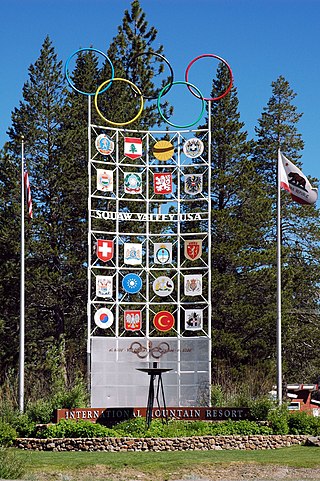
Olympic Valley is an unincorporated community located in Placer County, California northwest of Tahoe City along California State Highway 89 on the banks of the Truckee River near Lake Tahoe. It is home to Palisades Tahoe, the site of the 1960 Winter Olympics. Olympic Valley is the smallest resort area to host the Olympic Winter Games.

Palisades Tahoe is a ski resort in the western United States, located in Olympic Valley, California, northwest of Tahoe City in the Sierra Nevada range. From its founding in 1949, the resort was known as Squaw Valley, but it changed its name in 2021 due to the derogatory connotations of the word "squaw". It was the host site for the 1960 Winter Olympics.

The Granite Chief Wilderness is a 19,048 acre (77 km2) federally designated wilderness area of the Tahoe National Forest. Created by the California Wilderness Act of 1984, it is located in the Sierra Nevada mountains west of Lake Tahoe in the U.S. state of California. It is managed by the U.S. Forest Service Tahoe National Forest. Elevations range from 4,800 feet (1,500 m) to 9,019 feet (2,749 m) at the summit of Granite Chief.
The English word squaw is an ethnic and sexual slur, historically used for Indigenous North American women. Contemporary use of the term, especially by non-Natives, is considered derogatory, misogynist, and racist.

Washoe Lake is a lake located near Carson City in the Washoe Valley of Washoe County, Nevada. It is a very shallow lake with a surface area that can vary greatly from year to year. Washoe Lake State Park sits on the lake's southeastern shore.

Washoe Lake State Park is a year-round public recreation area occupying 3,775 acres (1,528 ha) on the southeast shore of Washoe Lake in Washoe County, Nevada. The state park lies to the east of Lake Tahoe, approximately five miles (8.0 km) north of Carson City near U.S. Route 395. The area around the park is known for its high winds making Washoe Lake a popular destination for windsurfers.

Clinton Lake is a reservoir on the southwestern edge of Lawrence, Kansas. The lake was created by the construction of the Clinton Dam, and the 35 square miles (91 km2) of land and water is maintained by the U.S. Army Corps of Engineers.

Cherry Creek is a large, swift-flowing stream in the Sierra Nevada mountain range, and is the largest tributary of the Tuolumne River. The creek is 44.6 miles (71.8 km) long measured to its farthest headwaters; the main stem itself is 27.7 miles (44.6 km) long, draining a watershed of 234 square miles (610 km2) in the Stanislaus National Forest. Part of the drainage also extends into the northwest corner of Yosemite National Park.
Comanche Creek Reservoir is a 3,275-acre (13.3 km²) impoundment located between Glen Rose, Texas and Granbury, Texas. The primary purpose is cooling for Comanche Peak Nuclear Generating Station. During full operation of both units of Comanche Peak, 2.2 million US gallons (8,300 m3) of water are pumped through the plant's main condensers from Comanche Creek Reservoir.

Martis Creek is a northward-flowing stream originating on Sawtooth Ridge, west of the peak of Mount Pluto in Placer County, California, United States. After crossing into Nevada County, California, it is a tributary to the Truckee River on the eastern side of Truckee.

Ophir Creek is a 7.7-mile (12.4 km) eastward-flowing stream originating in Tahoe Meadows just south of Tamarack Peak and southeast of Mount Rose Summit, a pass on Nevada State Highway 431. Ophir Creek flows to Washoe Lake in Washoe County in western Nevada, shortly after passing under U.S. Route 395.
Caples Lake is a reservoir that is located near Kirkwood, California along California State Route 88. The lake was used as a halting place for wagon travelers who were trekking the historic Mormon Trail during the California Gold Rush. The lake has been used by many different groups of people including Native Americans, 49ers, and resort owners, so it has been known by different names. The variant names are Clear Lake, Summit Lake, and Twin Lakes. Currently, Caples Lake is a reservoir used for water and recreation. Woods Creek and Emigrant Creek both flow into Caples Lake, which drains into Caples Creek. Caples Creek meets up with the South Fork of the American River. It is operated by the El Dorado Irrigation District (EID), who is using it as part of the Hydroelectric Project 184 system.

Independence Lake is a natural glacial lake in the Sierra Nevada of California. At an elevation of 6,949 feet (2,118 m) in the upper reaches of the Truckee River basin, it has been less affected by development than most lakes in the area. The Nature Conservancy owns a 2,325 acres (9.41 km2) parcel of land around it, which it manages privately as the Independence Lake Preserve for the purposes of conservation and low-impact recreation.
Hope Valley is a broad mountain valley in Alpine County, California, located on the eastern slope of the Sierra Nevada to the northeast of Carson Pass and south of Lake Tahoe. The valley served as a major thoroughfare for the passage of settlers and emigrants to and from California during the Gold Rush era. Sitting at an elevation of just above 7,000 feet (2,100 m) and framed by peaks reaching over 10,000 feet (3,000 m) high, Hope Valley is known for its wide vistas, fly fishing, fall colors, and winter activities.

