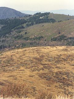
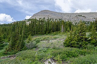
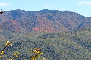
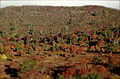
Graveyard Fields is the name of a flat mountain valley in the Blue Ridge Mountains of western North Carolina. It is located in the Great Balsam Mountains. The valley, itself over 5,000 feet in elevation, is surrounded by mountains exceeding 6,000 feet in elevation, such as Black Balsam Knob, Tennent Mountain, and Sam Knob. These high peaks form the source of the Yellowstone Prong of the Pigeon River, which flows through Graveyard Fields valley. Yellowstone Prong goes over 3 waterfalls in the valley: Upper Falls, Second Falls, and Yellowstone Falls.[1] Graveyard Fields is a very popular hiking destination, accessible from the Blue Ridge Parkway.
The valley's name may originate from a time when a great windstorm fell hundreds of spruce and fir trees on its slopes. These moss-covered stumps resembled graves. Another theory says that extensive logging during the early 1900s left stumps behind. Mosses and lichens grew on the stumps, resembling an overgrown graveyard.
Later, during the time when this area was logged, major forest fires swept through the area. These fires devastated the entire valley, and heated the soil enough to sterilize it. Even now, plants have difficulty growing in the fire-ravaged soils, although some trees, shrubs, and grasslands are slowly beginning to thrive.
Today, some forest has started to regrow, with species such as Red Spruce and Catawba Rhododendron, however much of the valley is still open and only covered in shrubs.
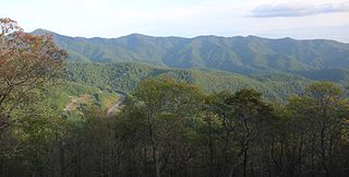
Graveyard Fields in Autumn
Second Falls with Black Balsam Knob in the background
The Appalachian Mountains, often called the Appalachians, are a system of mountains in eastern to northeastern North America. The Appalachians first formed roughly 480 million years ago during the Ordovician Period. They once reached elevations similar to those of the Alps and the Rocky Mountains before experiencing natural erosion. The Appalachian chain is a barrier to east–west travel, as it forms a series of alternating ridgelines and valleys oriented in opposition to most highways and railroads running east–west.
Haywood County is a county located in the U.S. state of North Carolina. As of the 2020 Census, the population was 62,089. The county seat and its largest city is Waynesville. Haywood County is part of the Asheville, NC Metropolitan Statistical Area.
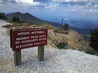
Mount Mitchell, known in Cherokee as Attakulla, is the highest peak of the Appalachian Mountains and the highest peak in mainland eastern North America. It is located near Burnsville in Yancey County, North Carolina; in the Black Mountain subrange of the Appalachians, about 19 miles (31 km) northeast of Asheville. It is protected by Mount Mitchell State Park and surrounded by the Pisgah National Forest. Mount Mitchell's elevation is 6,684 feet (2,037 m) above sea level.
The Blue Ridge Parkway is a National Parkway and All-American Road in the United States, noted for its scenic beauty. The parkway, which is America's longest linear park, runs for 469 miles (755 km) through 29 Virginia and North Carolina counties, linking Shenandoah National Park to Great Smoky Mountains National Park. It runs mostly along the spine of the Blue Ridge, a major mountain chain that is part of the Appalachian Mountains. Its southern terminus is at U.S. Route 441 (US 441) on the boundary between Great Smoky Mountains National Park and the Qualla Boundary of the Eastern Band of Cherokee Indians in North Carolina, from which it travels north to Shenandoah National Park in Virginia. The roadway continues through Shenandoah as Skyline Drive, a similar scenic road which is managed by a different National Park Service unit. Both Skyline Drive and the Virginia portion of the Blue Ridge Parkway are part of Virginia State Route 48 (SR 48), though this designation is not signed.
Mount Mitchell State Park is a 4,789-acre (1,938 ha) North Carolina state park in Yancey County, North Carolina in the United States. Established in 1915 by the state legislature, it became the first state park of North Carolina. By doing so, it also established the North Carolina State Parks System within the same bill.
Mount Pisgah is a mountain in the Appalachian Mountain Range and part of the Blue Ridge Mountains of North Carolina, United States. The mountain's height is 5,721 feet above sea level, and it sits approximately 15 miles southwest of Asheville, near the crossing of the boundaries of Buncombe, Haywood, Henderson and Transylvania counties. It is located on the border of Buncombe and Haywood counties, close to the point where Henderson and Transylvania meet them, but not actually within the latter two counties. The mountain is easily accessible via a hiking trail from the Blue Ridge Parkway, near the Pisgah Inn.
Pisgah National Forest is a National Forest in the Appalachian Mountains of western North Carolina. It is administered by the United States Forest Service, part of the United States Department of Agriculture. The Pisgah National Forest is completely contained within the state of North Carolina. The forest is managed together with the other three North Carolina National Forests from common headquarters in Asheville, North Carolina. There are local ranger district offices located in Pisgah Forest, Mars Hill, and Nebo.
The Black Mountains are a mountain range in western North Carolina, in the southeastern United States. They are part of the Blue Ridge Province of the Southern Appalachian Mountains. The Black Mountains are the highest mountains in the Eastern United States. The range takes its name from the dark appearance of the red spruce and Fraser fir trees that form a spruce-fir forest on the upper slopes which contrasts with the brown or lighter green appearance of the deciduous trees at lower elevations. The Eastern Continental Divide, which runs along the eastern Blue Ridge crest, intersects the southern tip of the Black Mountain range.
North Carolina Highway 215 (NC 215) is a highway in western North Carolina that runs from the town of Rosman in Transylvania County to Canton at Interstate 40 and U.S. Route 74 (US 74). The portion from Canton to Rosman is a part of the US Forest Service's Forest Heritage Scenic Byway. It travels high into the mountains along a scenic stretch of the upper West Fork of the Pigeon River, and intersects the Blue Ridge Parkway at Beech Gap at an elevation of approximately 5,300 feet (1,600 m).
The Appalachian–Blue Ridge forests are an ecoregion in the Temperate broadleaf and mixed forests Biome, in the Eastern United States. The ecoregion is located in the central and southern Appalachian Mountains, including the Ridge-and-Valley Appalachians and the Blue Ridge Mountains. It covers an area of about 61,500 square miles (159,000 km2) in: northeast Alabama and Georgia, northwest South Carolina, eastern Tennessee, western North Carolina, Virginia, Maryland, and central West Virginia and Pennsylvania; and small extensions into Kentucky, New Jersey, and New York.
The Art Loeb Trail is a 30.1-mile (48.4 km) hiking trail located in Pisgah National Forest in Western North Carolina. The northern terminus is at the Daniel Boone Boy Scout Camp in Haywood County, while the trail's southern terminus is located near the Davidson River Campground, near Brevard, in Transylvania County. Along the way, the trail traverses several significant peaks, including Black Balsam Knob (6,214 ft), Tennent Mountain (6040 ft) and Pilot Mountain (5095 ft). The trail also passes the base of Cold Mountain, made famous by the novel and film.
Woody's Knob, at an elevation of 4,170 feet, is a summit or "knob" in the Blue Ridge Mountains and one of the highest points in the unincorporated village of Little Switzerland and in Mitchell County, North Carolina.
Black Balsam Knob, also known as Black Balsam Bald, is in the Pisgah National Forest southwest of Asheville, North Carolina, near milepost 420 on the Blue Ridge Parkway. It is the second highest mountain in the Great Balsam Mountains. The Great Balsams are within the Blue Ridge Mountains, which are part of the Appalachian Mountains. It is the 23rd highest of the 40 mountains in North Carolina over 6000 feet.
The Great Balsam Mountains, or Balsam Mountains, are in the mountain region of western North Carolina, United States. The Great Balsams are a subrange of the Blue Ridge Mountains, which in turn are a part of the Appalachian Mountains. The most famous peak in the Great Balsam range is Cold Mountain, which is the centerpiece of author Charles Frazier's bestselling novel Cold Mountain.
Fir and spruce forests are greatly affected by slight fluctuations in climate. Temperature is the primary determinate for spatial patterns of fir and spruce. The two dominant trees in this type of forest are Picea engelmannii and Abies lasiocarpa. Although thick-barked trees, such as the Pinus resinosa, frequently survive fire, the thin bark of spruce make them more vulnerable. Trees such as the Douglas fir withstand much of the fire due to the thicker bark they have. The scale of the burn mosaic during a fire, relative to species niche requirements and mobility, can have major impacts on flora and fauna dynamics.
In peak bagging terminology in the United States, the Southern Sixers refers to the group of mountains in the southern states of North Carolina and Tennessee with elevations above sea level of at least six thousand feet. The southern sixers are the tallest group of mountains in the eastern United States and the only peaks in the Appalachian Mountains besides New Hampshire's Mount Washington to exceed 6,000 feet.
Marks Knob is a mountain in the Great Smoky Mountains, in the southeastern United States. It has an elevation of 6,169 feet (1,880 m), with 249 feet (76 m) of clean prominence. Its summit— located near the center of the Eastern Smokies amidst a dense stand of Southern Appalachian spruce-fir forest— is a popular bushwhacking destination and one of the most difficult-to-reach summits of the Southern Sixers.
The Plott Balsams are a mountain range in western North Carolina, in the southeastern United States. They are part of the Blue Ridge Mountain Province of the Southern Appalachian Mountains. The Plott Balsams stretch from the city of Sylva in the Tuckasegee River valley to the southwest to Maggie Valley in the northeast. The Great Smoky Mountains border the Plott Balsams to the north and the Great Balsam Mountains border the range to the south. The range comprises parts of Jackson County and Haywood County.
Richland Balsam is a mountain in the Great Balsam Mountains in the U.S. state of North Carolina. Rising to an elevation of 6,410 feet (1,950 m), it is the highest mountain in the Great Balsam range, is among the 20 highest summits in the Appalachian range, and is the ninth highest peak in the East of the United States. The Blue Ridge Parkway reaches an elevation of 6,053 feet (1,845 m)— the parkway's highest point— as it passes over Richland Balsam's southwestern slope. The Jackson County-Haywood County line crosses the mountain's summit.
The southern Appalachian spruce–fir forest is an ecoregion of the temperate coniferous forests biome, a type of montane coniferous forest that grows in the highest elevations in the southern Appalachian Mountains of the eastern United States.
This page is based on this Wikipedia article Text is available under the CC BY-SA 4.0 license; additional terms may apply. Images, videos and audio are available under their respective licenses.

 Graveyard Fields in Autumn
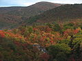 Second Falls with Black Balsam Knob in the background
 Second Falls