
The Great Falls and Old Dominion Railroad (GF&OD) was an interurban trolley line that ran in Northern Virginia during the early 20th century.
The Great Falls and Old Dominion Railroad (GF&OD) was an interurban trolley line that ran in Northern Virginia during the early 20th century.

Chartered in 1900 by a group of local landowners and acquired in 1902 by John Roll McLean (owner of The Washington Post ) and Senator Stephen Benton Elkins, [1] the 15-mile electrified railroad began operating from Georgetown in Washington, D.C., in 1906. The first trial run was in March 1906, but only went as far as Difficult Run and the first scheduled car reached Great Falls Park in Fairfax County, Virginia, on July 3 of that year. [2] They laid a second track in 1908. [3]
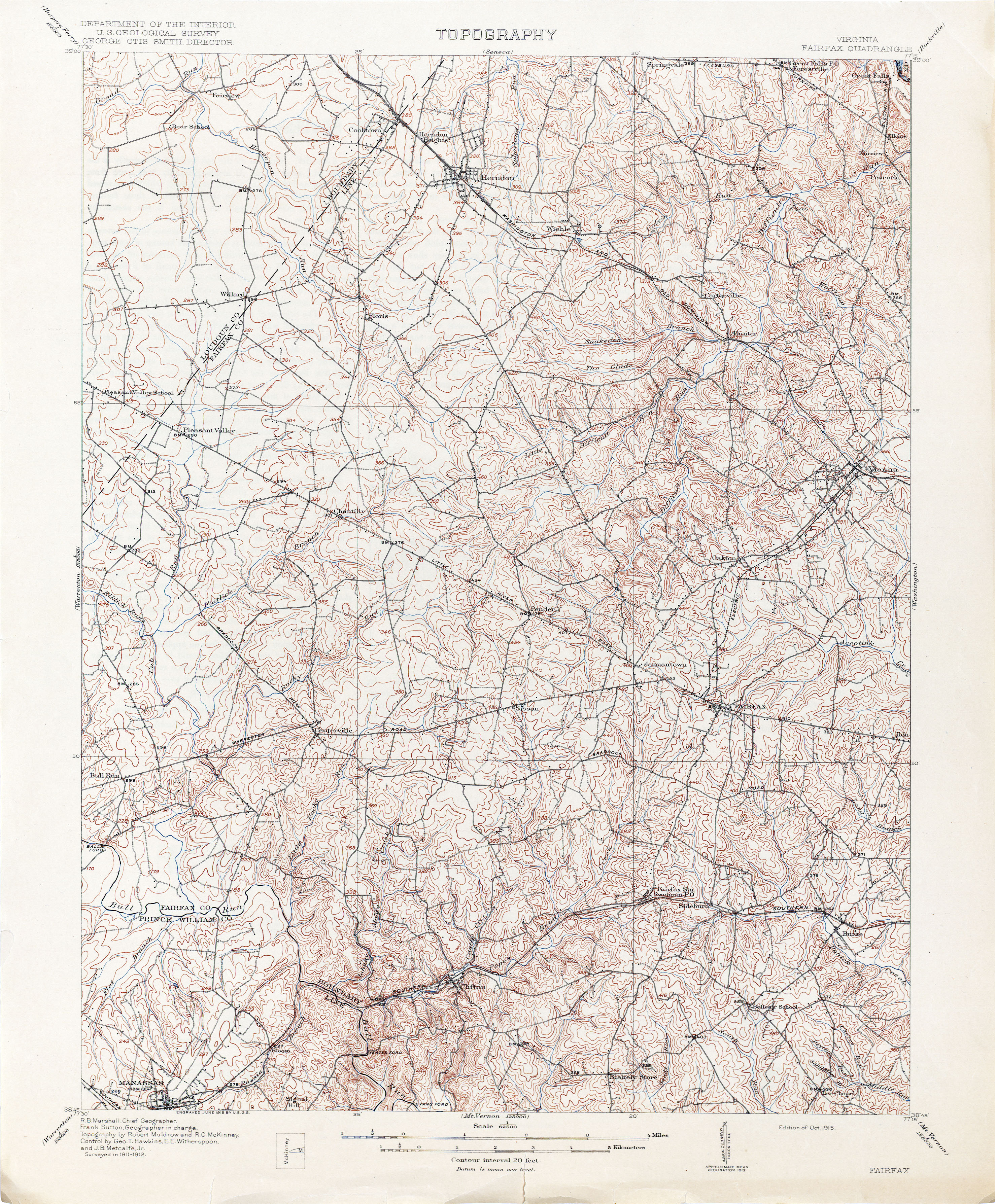
From Georgetown, the railroad crossed the Potomac River on a superstructure built on the upstream side of the old Aqueduct Bridge to Rosslyn in Arlington, where it made connections with an older electric trolley line, the Washington, Arlington & Falls Church Railway (see Northern Virginia trolleys). [4] From Rosslyn, the railroad traveled northwest along the north side of Lee Highway (now part of U.S. Route 29) to Cherrydale and then on its own right-of-way (now Old Dominion Drive, Virginia State Route 309) in Arlington and Fairfax Counties through forests, farmland and fruit orchards, bypassing the existing villages of Lewinsville and Langley. [5] At Great Falls, the GF&OD constructed a trolley park, which became a popular destination.
The owners gave their own names to two stations located at the railroad's crossings of major roads: McLean Station at Chain Bridge Road (Virginia State Route 123) and Elkins Station at Old Georgetown Pike (Virginia State Route 193). The station at Chain Bridge Road became a focus for development that evolved into the community of McLean, Virginia.
In 1911, McLean and Elkins incorporated the Washington & Old Dominion Railway (W&OD) and in 1912, the new W&OD signed a 50-year lease on the Southern Railway's Alexandria-Bluemont line. In the same year, it then constructed a double-tracked Bluemont Division connecting line that traveled between two new junctions in Arlington: Bluemont Junction on the Alexandria-Bluemont line and Thrifton Junction on the Georgetown-Great Falls line. The Georgetown-Great Falls line became the Great Falls Division of the W&OD, sharing trackage with the W&OD's Bluemont Division between Rosslyn and Thrifton Junction. In 1935, Fairfax and Arlington counties obtained the right-of-way west of Thrifton Junction in settlement of delinquent taxes. Most of the right-of-way was converted into Old Dominion Drive.
Not much remains of the Great Falls Division.
The right-of-way west of Thrifton Junction became Langston Blvd (formally Lee Highway) and Old Dominion Drive; and the right-of-way between the Key Bridge and Thrifton Junction became Interstate 66. The trestle over Difficult Run lasted until 1979, when it was replaced because it could not handle the loads required of it. [6]
Great Falls Trolley Park became Great Falls Park, part of the National Park Service.
Several area names, like the town of McLean, also remain.
The stations on the Great Falls Division of the W&OD (with locations of sites in 2008) were:
| Station [7] | Location | Coordinates | Jurisdiction | Side of Tracks [8] | Photo | Notes |
|---|---|---|---|---|---|---|
| Georgetown [9] | M Street, N.W., between 35th and 37th Streets, N.W. | 38°54′19″N77°04′13″W / 38.90519°N 77.070293°W | District of Columbia | West | Terminal station of GF&OD and W&OD until 1923. Adjacent to Georgetown Car Barn, which served Washington's electric street cars. | |
| Rosslyn [9] | Passenger Terminal (1923 to 1938): Fort Myer Drive (west side) between George Washington Memorial Parkway and Lee Highway | 38°53′58″N77°04′18″W / 38.89957°N 77.071785°W | Arlington County | West | Undated photo of front of station Undated colorized postcard & 1923 interior photo of passenger terminal 1948 | The GF&OD and W&OD stopped at a passenger shelter from 1904 to 1923. The W&OD terminated behind a passenger station on Fort Myer Drive from 1923 to 1938. The railroad terminated near a maintenance shop in the present route of I-66 a short distance west of Fort Myer Drive from 1938 to 1964. All of the Rosslyn stations and termini were near the present site of the Key Bridge Marriott Hotel Archived August 10, 2006, at the Wayback Machine . Historical Marker: Rosslyn Station [10] |
| Colonial [9] | I-66 at N. Nash Street | 38°53′55″N77°04′25″W / 38.89866°N 77.07374°W | Arlington County | South | ||
| Rosslyn Freight House [9] | I-66 near N. Oak Street | 38°53′55″N77°04′32″W / 38.898682°N 77.075433°W | Arlington County | North | 1959 circa 1963 | |
| Mackeys [9] | I-66 at N. Quinn Street | 38°53′52″N77°04′44″W / 38.8978717°N 77.078914°W | Arlington County | Northwest | ||
| Park Lane [9] | I-66 east of N. Uhle Street; north of Lee Highway | 38°53′50″N77°05′04″W / 38.89709°N 77.084509°W | Arlington County | Southwest | ||
| Pearce [9] | I-66 near N. Adams Street | 38°53′54″N77°05′22″W / 38.89823°N 77.089466°W | Arlington County | South | ||
| Clark [9] | I-66 near N. Calvert Street | 38°53′52″N77°05′35″W / 38.89782°N 77.092985°W | Arlington County | South | Near east side of Spout Run. | |
| Thrifton [9] | I-66 between Lee Highway and Spout Run Parkway | 38°53′48″N77°05′53″W / 38.896626°N 77.098048°W | Arlington County | South | North of Lyon Village shopping center near southeast end of Maywood Historic District. [11] Named for Hugh A. Thrift. [12] East of junction with Thrifton – Bluemont Junction connecting line. | |
| Dominion Heights [13] | Lee Highway (between traffic lanes) at N. Monroe Street (east side) [14] | 38°53′46″N77°06′15″W / 38.8960055°N 77.1040356°W | Arlington County | South | Adjacent to Maywood Historic District [14] | |
| Cherrydale [13] | Intersection of Lee Highway and Old Dominion Drive at Military Road (east side) | 38°53′49″N77°06′30″W / 38.8969741°N 77.1083701°W | Arlington County | Southwest | circa 1908 | |
| Harrison [13] | Old Dominion Drive at N. Thomas Street | 38°53′58″N77°06′51″W / 38.89947°N 77.114174°W | Arlington County | South | ||
| Greenwood [13] (Lee Heights) [15] | Old Dominion Drive at Lorcom Lane (northwest side); east of N. Upton Street | 38°53′57″N77°07′01″W / 38.8991534°N 77.1170604°W | Arlington County | South | ||
| Maplewood [13] | Old Dominion Drive between traffic lanes north of Lee Highway; west of N. Abingdon Street | 38°53′55″N77°07′17″W / 38.89867°N 77.12139°W | Arlington County | South | ||
| Livingston [13] (Livingstone Heights) [16] | Old Dominion Drive at 24th Street N. (north side) | 38°54′03″N77°07′28″W / 38.90073°N 77.124431°W | Arlington County | Southwest | 24th Street N. was Livingstone Street prior to 1935 (named for Colin H. Livingstone) [17] | |
| Lyonhurst [13] | Old Dominion Drive at 25th Street N. | 38°54′07″N77°07′33″W / 38.90189°N 77.125799°W | Arlington County | Southwest | Named for the nearby estate of Frank Lyon (now Missionhurst) | |
| Summit [13] | Old Dominion Drive at 26th Street N. (southeast side) | 38°54′10″N77°07′38″W / 38.902907°N 77.127108°W | Arlington County | Southwest | ||
| Rixey [13] | Old Dominion Drive at N. Glebe Road (east side) | 38°54′15″N77°07′43″W / 38.9042925°N 77.1286476°W | Arlington County | Northeast | undated | Named for the nearby estate of Dr. Presley Marion Rixey. Marymount University now occupies the Rixey estate. Later station on southwest side of tracks. [18] |
| Jewell [19] | Old Dominion Drive at Rock Spring Road (north side) | 38°54′28″N77°07′58″W / 38.90781°N 77.132692°W | Arlington County | Southwest | undated | Named for Charles Jewell |
| Vanderwerken [19] | Old Dominion Drive at Little Falls Road (northwest side) | 38°54′35″N77°08′13″W / 38.90980°N 77.136987°W | Arlington County | North | Named for Gilbert Vanderwerken | |
| Franklyn Park (Franklin Park) [19] | Old Dominion Drive at Franklin Park Road | 38°54′55″N77°08′54″W / 38.91540°N 77.148453°W | Fairfax County | Northeast | 1910 | |
| Rockwell [19] | Old Dominion Drive near Dominion Crest Lane | 38°55′06″N77°09′00″W / 38.9183177°N 77.1500731°W | Fairfax County | Southwest | ||
| Chesterbrook [19] | Old Dominion Drive at Kirby Road (northwest side) | 38°55′18″N77°09′13″W / 38.9215898°N 77.1535599°W | Fairfax County | Northeast | ||
| El Nido [20] | Old Dominion Drive at Birch Road | 38°55′26″N77°09′42″W / 38.92394°N 77.161762°W | Fairfax County | North | ||
| Selva [20] | Old Dominion Drive at 6th Place | 38°55′35″N77°09′57″W / 38.92639°N 77.165893°W | Fairfax County | Southwest | ||
| Viresco [20] | Old Dominion Drive between Pimmit Run and Linway Terrace | 38°55′44″N77°10′04″W / 38.928889°N 77.1678776°W | Fairfax County | Northeast | Southeast side of B&O Railroad right-of-way [21] [22] | |
| Lawnvale [20] | Old Dominion Drive near Holmes Place | 38°55′51″N77°10′22″W / 38.9309379°N 77.1728396°W | Fairfax County | Southwest | ||
| McLean [20] | Old Dominion Drive at Chain Bridge Road (northwest side) | 38°56′03″N77°10′40″W / 38.93404°N 77.177692°W | Fairfax County | Northeast | Named for John Roll McLean | |
| Ingleside [20] | Old Dominion Drive at Ingleside Avenue | 38°56′09″N77°10′59″W / 38.93582°N 77.182946°W | Fairfax County | Northeast | ||
| Balls Hill [23] | Old Dominion Drive at Balls Hill Road (east side) | 38°56′30″N77°11′39″W / 38.94159°N 77.19419°W | Fairfax County | West | ||
| Hitaffer [23] | Old Dominion Drive at Swinks Mill Road (south side) | 38°56′48″N77°12′41″W / 38.9466559°N 77.2114956°W | Fairfax County | Northeast | ||
| Jackson [23] | Old Dominion Drive northwest of Swinks Mill Road | 38°56′51″N77°12′50″W / 38.9474402°N 77.2139579°W | Fairfax County | Southwest | undated | |
| Spring Hill [24] | Old Dominion Drive at Spring Hill Road (east side) | 38°57′10″N77°13′35″W / 38.95275°N 77.226382°W | Fairfax County | Northeast | ||
| Prospect Hill [24] | Old Dominion Drive at Bellview Place | 38°57′30″N77°14′11″W / 38.95836°N 77.236467°W | Fairfax County | Northeast | undated | |
| Belleview [24] | Old Dominion Drive at Bellview Road | 38°57′40″N77°14′25″W / 38.96098°N 77.240308°W | Fairfax County | Southwest | undated | |
| Glendale [25] | Old Dominion Drive at Towlston Road | 38°58′12″N77°14′58″W / 38.96998°N 77.249559°W | Fairfax County | Southwest | ||
| Peacock [25] | Old Dominion Drive at Peacock Station Road (east side) | 38°58′25″N77°15′12″W / 38.97348°N 77.253223°W | Fairfax County | Southwest | undated | |
| Fairview [25] | Old Dominion Drive at Falls Run Road | 38°58′40″N77°15′26″W / 38.97777°N 77.257141°W | Fairfax County | West | ||
| Elkins [25] | Old Dominion Drive at Georgetown Pike (north side) | 38°58′54″N77°15′25″W / 38.98177°N 77.25686°W | Fairfax County | West | undated undated | Named for Stephen Benton Elkins. |
| Dickeys Road | Old Dominion Drive in Great Falls Park | 38°59′36″N77°15′20″W / 38.99338°N 77.255688°W | Fairfax County (National Park Service) | Named for Dickey's Inn. Near former site of Matildaville. | ||
| Great Falls [25] | Old Dominion Drive in Great Falls Park | 38°59′48″N77°15′19″W / 38.99663°N 77.255355°W | Fairfax County (National Park Service) | Inside turnaround | undated postcard | Terminal station of GF&OD and Great Falls Division of W&OD. |

Ballston is a neighborhood in Arlington County, Virginia. Ballston is located at the western end of the Rosslyn-Ballston corridor. It is a major transportation hub and has one of the nation's highest concentrations of scientific research institutes and research and development agencies, including DARPA, the Office of Naval Research, the Advanced Research Institute of Virginia Tech, the Air Force Research Laboratory, and engineering, management, and public sector consulting firms. Ballston also includes a section known as Virginia Square and sometimes the area is collectively known as Ballston-Virginia Square.

The Richmond, Fredericksburg, and Potomac Railroad was a railroad connecting Richmond, Virginia, to Washington, D.C. The track is now the RF&P Subdivision of the CSX Transportation system; the original corporation is no longer a railroad company.

The Washington and Old Dominion Railroad was an intrastate short-line railroad located in Northern Virginia, United States. The railroad was a successor to the bankrupt Washington and Old Dominion Railway and to several earlier railroads, the first of which began operating in 1859. The railroad closed in 1968.

The Washington and Old Dominion Railroad Regional Park is a linear regional park in Northern Virginia. The park's primary feature is the Washington and Old Dominion Railroad Trail, an asphalt-surfaced paved rail trail that runs through densely populated urban and suburban communities as well as through rural areas. Most of the trail travels on top of the rail bed of the former Washington and Old Dominion Railroad, which closed in 1968.

Great Falls Park is a small National Park Service (NPS) site in Virginia, United States. Situated on 800 acres (3.2 km2) along the banks of the Potomac River in northern Fairfax County, the park is a disconnected but integral part of the George Washington Memorial Parkway. The Great Falls of the Potomac River are near the northern boundary of the park, as are the remains of the Patowmack Canal, the first canal in the United States that used locks to raise and lower boats.

Streetcars in Washington, D.C. transported people across the city and region from 1862 until 1962.

Four Mile Run is a 9.4-mile-long (15.1 km) stream in Northern Virginia that starts near Interstate 66, at Gordon Avenue in Fairfax County and proceeds southeast through Falls Church to Arlington County in the U.S. state of Virginia. Most of the stretch is parkland and is paralleled by two paved non-motorized transport and recreational trails, the Washington and Old Dominion Railroad Trail and the Four Mile Run Trail.

The Custis Trail is a hilly 4.5 miles (7.2 km)-long shared use path in Arlington County, Virginia. The asphalt-paved trail travels along Interstate 66 (I-66) between Rosslyn and the Washington and Old Dominion Railroad Trail at Bon Air Park.

The Northern Virginia trolleys were the network of electric streetcars that moved people around the Northern Virginia suburbs of Washington, D.C., from 1892 to 1941. They consisted of six lines operated by up to three companies connecting Rosslyn, Great Falls, Bluemont, Mount Vernon, Fairfax, Camp Humphries, and Nauck across the Potomac River to Washington, D.C.

The Aqueduct Bridge, also called the Alexandria Aqueduct, was a bridge that carried traffic between Georgetown, Washington, D.C., and Rosslyn, Virginia, from 1843 to 1923.

The Alexandria Canal was a canal in the United States that connected the city of Alexandria to Georgetown in the District of Columbia.
The Capital Traction Company was the smaller of the two major street railway companies in Washington, D.C., in the early 20th century.
Northern Virginia is part of the Washington Metropolitan Area of the United States, and its surface transit system is integrated with that of the city of Washington, D.C. However, because of the Potomac River separating Northern Virginia from the city, the two systems have evolved largely independently. At present, most major bus routes, including all that cross the Potomac, are operated by the Washington Metropolitan Area Transit Authority (WMATA), while several smaller systems are city- or county-owned. Since the Washington Metro opened to Virginia, most of the bus routes have terminated on either side of the Potomac River, where passengers can transfer to the rapid transit system, or to one of the few WMATA Metrobus routes that cross the river.

Colin Hamilton Livingstone was an American banker and a president of the Washington and Old Dominion Railway, the Virginia Shipbuilding Corporation in Alexandria, and the Washington and Virginia Real Estate Company. He was also the first national president of the Boy Scouts of America (BSA).

The Bluemont Junction Trail is a 1.2-mile (1.9 km) asphalt-paved rail trail in Arlington County, Virginia, United States, that the Arlington County government constructed along a former branch of the defunct Washington and Old Dominion Railroad. The shared use path travels southwest from Ballston through Bluemont Junction Park to Bluemont Junction. The trail connects Ballston to the Washington and Old Dominion Railroad Trail and the Four Mile Run Trail in and near Bluemont Park.

The Four Mile Run Trail is a 7-mile long, paved shared use path in Arlington County and Falls Church. It runs along Four Mile Run from Benjamin Banneker Park in Falls Church to the Mount Vernon Trail near Ronald Reagan Washington National Airport, where Four Mile Run empties into the Potomac River. The trail runs roughly parallel to parts of the Washington & Old Dominion Railroad Trail as it follows Four Mile Run, sometimes on the other side of the stream.
The Maywood Historic District is a national historic district located in Arlington County, Virginia. It contains 198 contributing buildings in a residential neighborhood located in the northern part of the county. The area was platted and subdivided in five sections between 1909 and 1913 following the arrival in 1906 of the Great Falls and Old Dominion Railroad. The area was primarily developed between 1909 and 1929. The dwelling styles include a variety of architectural styles, including Queen Anne, Colonial Revival foursquares, Bungalow, and two-story gable-front houses. Several dwellings in the neighborhood have been identified as prefabricated mail-order houses.
Nauck is a neighborhood in the southern part of Arlington County, Virginia, known locally as Green Valley. It is bordered by Four Mile Run and Shirlington to the south, Douglas Park to the west, I-395 to the east, and Columbia Heights and the Army-Navy Country Club to the north. The southeastern corner of the neighborhood borders the City of Alexandria.

Bluemont is a suburban neighborhood in Arlington County, Virginia. As of 2020, the population is 7,049 people. The neighborhood is bounded on the north by Washington Boulevard and on the south by Carlin Springs Road. The western boundary is Four Mile Run and the eastern boundary is Glebe Road.

The Bluemont Junction was part of the Washington and Old Dominion Railway that began operation in 1912. Located in Bluemont, Arlington, the wye junction served as a transfer point for passengers and freight from Alexandria and Georgetown to points west ending at Bluemont, the a popular resort in the Blue Ridge Mountains.