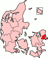
Copenhagen County is a former county (amt) on the island of Zealand (Sjælland) in eastern Denmark. It covered the municipalities in the metropolitan Copenhagen area, with the exception of Copenhagen and Frederiksberg. Effective January 1, 2007, the county was abolished and merged into Region Hovedstaden.

Brøndby Kommune, a municipality in the former Copenhagen County, is on the east coast of the island of Zealand (Sjælland) in eastern Denmark. The municipality covers an area of 20.85 km2 (8.05 sq mi), and has a total population of 37,128 (2023). Its mayor Kent Max Magelund, a member of the Social Democrats (Socialdemokraterne) political party.
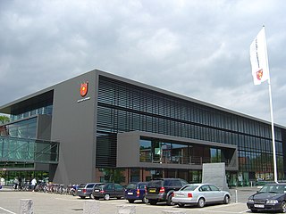
Glostrup Municipality is a suburban municipality and town in Region Hovedstaden on the island of Zealand (Sjælland) approx. 10 km west of Copenhagen in eastern Denmark. The municipality covers an area of 13.31 km², and has a total population of 23,635 (2023). Its Zip code (Postnummer) is 2600. Its mayor as of 2022 is Kasper Damsgaard, a member of the Social Democrats (Socialdemokratiet) political party. The municipality was established in 1841 following the municipal reforms of the 1840s, ranking as a parish municipality (sognekommune) until 1950 when suburbanisation of Copenhagen inhabited the municipality and the status was changed to town municipality (købstadskommune). From 1947 to 1960 the population in the municipality doubled due to the expanding suburbs of Copenhagen, reaching the municipality in the post-war period. Glostrup was designated as a new suburb along the western Tåstrup-finger of the Copenhagen Finger Plan of 1947.

The S-Bahn is a hybrid urban-suburban rail system serving a metropolitan region predominantly in German-speaking countries. Some of the larger S-Bahn systems provide service similar to rapid transit systems, while smaller ones often resemble commuter or even regional rail systems. The name S-Bahn derives from Schnellbahn, Stadtbahn or Stadtschnellbahn.

The urban area of Copenhagen, lying mostly in the Capital Region of Denmark but also in Region Zealand, consist of Copenhagen and Frederiksberg municipalities and the former Copenhagen County. In all, it consists of 18 municipalities, and except parts of Ballerup, Greve, Ishøj, former Søllerød and former Værløse, mentioned with their population included from 2007. Ishøj and Greve Strand are included for the first time since 1999. As of 1 January 2022, this area had a population of 1,336,982. Statistics Denmark states that the definition of the urban area is based on UN's 200m definition.

The rail transport system in Denmark consists of 2,633 km of railway lines, of which the Copenhagen S-train network, the main line Helsingør-Copenhagen-Padborg, and the Lunderskov-Esbjerg line are electrified. Most traffic is passenger trains, although there is considerable transit goods traffic between Sweden and Germany.
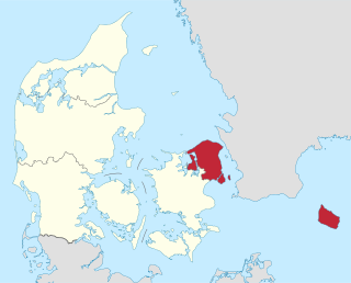
The Capital Region of Denmark is the easternmost administrative region of Denmark, and contains Copenhagen, the national capital.

Køge Bugt-banen is one of six radial S-train lines in Copenhagen; it connects the city center to communities along Køge Bugt and terminates in the city of Køge about 35 km southwest of central Copenhagen.
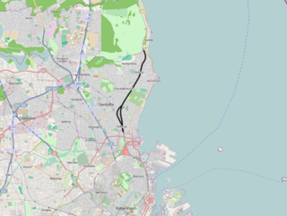
The Klampenborg Line is a railway line between Copenhagen and Klampenborg in the northern suburbs of Copenhagen, Denmark. It is the shortest of the six radial lines of Copenhagen's S-train network, a hybrid commuter rail and rapid transit system serving Greater Copenhagen.

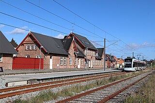
Glostrup station is a commuter rail railway station serving the railway town/suburb of Glostrup west of Copenhagen, Denmark.

Albertslund station is an S-train station serving the Danish capital Copenhagen suburb of Albertslund, west of the city.

Vallensbæk is a seaside western suburb of Copenhagen, Denmark. It is part of the Greater Copenhagen Area. It forms its own municipality, Vallensbæk Municipality, which is one of the smallest Danish municipalities. It borders Køge Bay, and the Køge Bay Beach Park along the coast. The suburb of Vallensbæk consists of two sections, not directly connected to each other: Vallensbæk Nordmark in the north and Vallensbæk Strand in the south. The two parts of the town are commonly referred to together as Vallensbæk.

The Finger Plan is an urban plan from 1947 which provides a strategy for the development of the Copenhagen metropolitan area, Denmark. According to the plan, Copenhagen is to develop along five 'fingers', centred on S-train commuter rail lines, which extend from the 'palm', that is the dense urban fabric of central Copenhagen. In between the fingers, green "wedges" are intended to provide land for agriculture and recreational purposes.

Super Bikeways in metropolitan Copenhagen are a network of high quality bikeways under development to promote commuting by bicycle in metropolitan Copenhagen, Denmark. A collaboration between Copenhagen Municipality and 18 surrounding municipalities in Greater Copenhagen, the objective is to facilitate and increase commuting by bicycle.

The Aarhus Letbane is a light rail system in the city of Aarhus, Denmark. It is operated by the company Midttrafik. The first line opened in December 2017, but the system is under continuous development and expansion. Service on the intercity section Odder to Lisbjergskolen opened on August 25, 2018. A third intercity line to Grenå opened on 30 April 2019. More lines are being planned.
Transport in Copenhagen and the surrounding area relies on a well established infrastructure making it a hub in Northern Europe thanks to its road and rail networks as well as its international airport. Thanks to its many cycle tracks, Copenhagen is considered to be one of the world's most bicycle-friendly cities. The metro and S-train systems are key features of the city's well-developed public transport facilities. Since July 2000, the Øresund Bridge has served as a road and rail link to Malmö in Sweden. The city is also served by ferry connections to Oslo in Norway while its award-winning harbour is an ever more popular port of call for cruise ships.

Trustrup station is a railway station serving the village of Trustrup on the Djursland peninsula in East Jutland, Denmark.
Ryomgård station is a railway station serving the railway town of Ryomgård on the peninsula of Djursland in Jutland, Denmark.

Vestegnen is a term for a part of the former Copenhagen County, located west of Copenhagen. The area is defined as consisting of the municipalities of Rødovre, Hvidovre, Glostrup, Brøndby, Albertslund, Køge, Vallensbæk, Ishøj and Høje-Taastrup and covers the area around some of the stations of the S-train, which are on the lines towards Høje Taastrup and Køge, and which are within the former Copenhagen County. The urban area of Hundige is often included due to its proximity to the rest of “Vestegnen” and the former terminus on the Køge Bugt-banen, but Hundige is located in Greve Municipality and thus neither in the former Copenhagen County nor the current Capital Region of Denmark.


