Greenwood Colony, South Dakota | |
|---|---|
 Greenwood Colony  Greenwood Colony | |
| Coordinates: 43°12′52″N98°09′13″W / 43.21444°N 98.15361°W | |
| Country | United States |
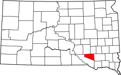
| State | South Dakota |
| County | Douglas |
| Area | |
• Total | 0.24 sq mi (0.61 km2) |
| • Land | 0.24 sq mi (0.61 km2) |
| • Water | 0 sq mi (0.00 km2) |
| Elevation | 1,614 ft (492 m) |
| Population | |
• Total | 11 |
| • Density | 46.9/sq mi (18.09/km2) |
| Time zone | UTC-6 (Central (CST)) |
| • Summer (DST) | UTC-5 (CDT) |
| ZIP Code | 57330 (Delmont) |
| Area code | 605 |
| FIPS code | 46-26150 |
| GNIS feature ID | 2813017 [2] |
Greenwood Colony is a Hutterite colony [4] and census-designated place (CDP) in Douglas County, South Dakota, United States. The population was 11 at the 2020 census. [5] It was first listed as a CDP prior to the 2020 census. [2]
Contents
It is in the southeast part of the county, bordered to the south by Charles Mix County. It is 5 miles (8 km) south of Delmont.