Gresham Hotel

Last updated

Hotel Riu Plaza The Gresham Dublin
GreshamHotel.svg
2009-09-27 Ireland Dublin Gresham Hotel 038a.jpg
Open street map central dublin.svg
Red pog.svg
Location within Central Dublin
General information
ClassificationStar full.svgStar full.svgStar full.svgStar full.svg
Address23 Upper O'Connell Street
Dublin 1, D01 C3W7
Coordinates 53°21′06″N6°15′38″W / 53.351666°N 6.260638°W / 53.351666; -6.260638
Opening1817
Owner RIU Hotels & Resorts
Management RIU Hotels & Resorts
Design and construction
Architect(s) Robert Atkinson
Other information
Number of rooms404
Website
Official website

The Hotel Riu Plaza The Gresham Dublin, formerly The Gresham Hotel, is a historic four-star hotel on O'Connell Street in Dublin, Ireland. It is a Dublin institution and landmark. Founded in 1817, the current structure was completed in 1927 and was completely refurbished in 2024. [1]

Contents

History

Background

Thomas Gresham, the hotel's founder, was a foundling child, abandoned on the steps of the Royal Exchange, London. He was named for the founder of that institution, Sir Thomas Gresham, a famous merchant-politician in the Elizabethan era. Gresham came to Ireland and as a young man obtained employment in the service of William Beauman of Rutland Square (now Parnell Square), Dublin. After some time, and while still comparatively young, he became butler to this family.

The first hotel

In 1817, Gresham left Beauman's household and purchased two adjoining Georgian townhouses at 21 and 22 Sackville Street (now O'Connell Street), combining them into a lodging house he named Gresham's Hotel, catering mostly to the wealthy aristocracy and MPs who passed through Dublin on their way to London. In 1820, Gresham bought the neighboring townhouse at 20 Sackville Street and expanded the establishment.

By 1834 Gresham was noted as owning the Royal Marine Hotel in Kingstown. In 1833 he was the main local spokesman for opposition to a bill for the Dublin and Kingstown Railway (D&KR) extension to Dalkey, spending £1,200 in the process and being awarded a silver plate from locals when the bill failed. On being requested not to oppose an 1834 bill for an extension to Kingstown only, he agreed, saying he would not have opposed the earlier bill if the railway had acted with more courtesy. He also accepted £400 for D&KR shares he had bought for £100 in recognition. [2]

The property was sold to a consortium in 1865, which renamed it The Gresham Hotel. [3] They rebuilt the establishment, reconstructing the facades of the three connected townhouses into a single unified hotel building. [4]

The hotel is the setting for the final third of James Joyce’s short story "The Dead", [5] set in the early years of the twentieth century. The story does not paint the hotel in a flattering light, referring to staff sleeping on duty and broken lighting.

During the Irish Civil War, the Gresham was occupied by Anti-treaty forces under the command of Cathal Brugha and Countess Markievicz. It was the site of heavy fighting during the Battle of Dublin and was burned to the ground on 6 July 1922. [3]

The modern hotel

The hotel's owners were awarded £93,550 in compensation by the new Irish Free State and they signed a contract with the McLaughlin & Harvey construction company on 29 October 1926 to build a 250-room replacement hotel. [6] The new structure was designed by English architect Robert Atkinson [3] and his business partner Alexander Frederick Berenbruck Anderson in a blend of the Art Deco and neo-classical styles. The rebuilt hotel opened on 16 April 1927. [7] Many historic features from this time remain, including Waterford crystal chandeliers. [8]

The hotel was bought by the Ryan Hotel group in 1978. Ryan Hotels was renamed Gresham Hotel Group in 2001. [9]

The Gresham was sold to the Spanish RIU Hotels & Resorts chain in September 2016 for €92 million, becoming the Hotel Riu Plaza The Gresham Dublin. [10]

In January 2018 Dublin City Council set about rehoming 14 homeless families that had been living at The Gresham to allow for the refurbishment of a number of bedrooms and suites at the hotel. [11]

The hotel completed a major renovation in 2024 that included a significant expansion, increasing the number of rooms by 16 to 404. [12]

Related Research Articles

<span class="mw-page-title-main">O'Connell Street</span> Key street of Dublin, Ireland

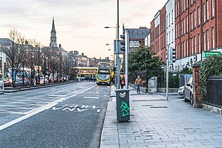
O'Connell Street is a street in the centre of Dublin, Ireland, running north from the River Liffey. It connects the O'Connell Bridge to the south with Parnell Street to the north and is roughly split into two sections bisected by Henry Street. The Luas tram system runs along the street.

<span class="mw-page-title-main">St Mary's Pro-Cathedral</span> Church in Dublin, Ireland

St Mary's Church, known also as St Mary's Pro-Cathedral or simply the Pro-Cathedral, the Chapel in Marlborough Street or the Pro, is a pro-cathedral and is the episcopal seat of the Catholic Archbishop of Dublin and Primate of Ireland.

<span class="mw-page-title-main">William Dargan</span> Irish railway engineer (1799–1867)

William DarganMRDS was arguably the most important Irish engineer of the 19th century and certainly the most important figure in railway construction. Dargan designed and built Ireland's first railway line from Dublin to Dún Laoghaire in 1833. In total he constructed over 1,300 km of railway to important urban centres of Ireland. He was a member of the Royal Dublin Society (RDS) and also helped establish the National Gallery of Ireland. He was also responsible for the Great Dublin Exhibition held at Leinster lawn in 1853. His achievements were honoured in 1995, when the Dargan Railway Bridge in Belfast was opened, and again in 2004 when the Dargan Bridge, Dublin a new cable stayed bridge for Dublin's Light Railway Luas were both named after him.

<span class="mw-page-title-main">Clerys</span> Former department store and related shops in Dublin, Ireland

Clerys was a long-established department store on O'Connell Street in Dublin, Ireland, a focal point of the street. The business dates from 1853, however the current building dates from 1922, the original having been completely destroyed in the 1916 Easter Rising. Clerys completed a five-year restoration programme in 2004 at a cost of €24 million but went into receivership in 2012, and was sold. Under American ownership, it abruptly closed in 2015, and issues arose with staff and franchise holders over an extended period afterwards.

Cabra is an inner suburb on the northside of Dublin city in Ireland. It is approximately 2 kilometres (1.2 mi) northwest of the city centre, in the administrative area of Dublin City Council. It was commonly known as Cabragh until the early 20th century. Largely located between the Royal Canal and the Phoenix Park, it is primarily a residential suburb, with a range of institutions and some light industry. Cabra is served by bus, tram and mainline rail; it lies across Navan Road, one of the main roads from central Dublin to the orbital motorway.

<span class="mw-page-title-main">Dublin and South Eastern Railway</span> Irish railway company 1845 to 1924

The Dublin and South Eastern Railway (DSER), often referred to as the Slow and Easy, was an Irish gauge railway in Ireland from 1846 to 1925. It carried 4,626,226 passengers in 1911. It was the fourth largest railway operation in Ireland operating a main line from Dublin to Wexford, with branch lines to Shillelagh and Waterford. The company previously traded under the names Waterford, Wexford, Wicklow & Dublin Railway to 1848, Dublin and Wicklow Raillway (D&WR) to 1860 and Dublin, Wicklow and Wexford Railway (DW&WR) until 1906.

<span class="mw-page-title-main">Dún Laoghaire railway station</span> Rail station in Ireland

Dún Laoghaire (Mallin) railway station is a station in Dún Laoghaire, Dún Laoghaire–Rathdown, Ireland.

<span class="mw-page-title-main">Dublin and Kingstown Railway</span> Irelands first passenger railway (1834–1856)

The Dublin and Kingstown Railway (D&KR), which opened in 1834, was Ireland's first passenger railway. It linked Westland Row in Dublin with Kingstown Harbour in County Dublin.

<span class="mw-page-title-main">Booterstown</span> Suburb of Dublin, Ireland

Booterstown is a coastal suburb of the city of Dublin in Ireland. It is also a townland and civil parish in the modern county of Dún Laoghaire–Rathdown. It is situated about 7 km (4.3 mi) south of Dublin city centre.

<span class="mw-page-title-main">Limerick Colbert railway station</span> Railway station in Limerick, Ireland

Limerick railway station also known as Colbert Station or Limerick Colbert serves the city of Limerick in County Limerick, Ireland. It is on Parnell Street and is the main station on the Limerick Suburban Rail network. It has approximately 2,500 rail passengers a day travelling on four rail routes. The Bus Éireann bus station on site services approximately one million passengers a year, with 125 buses departing each day.

<span class="mw-page-title-main">O'Connell Street, Limerick</span> Main street of Limerick city, Ireland

O'Connell Street is the main thoroughfare of the city of Limerick. It was previously known as George's Street until it was renamed after Daniel O'Connell. The street runs in parallel to the River Shannon and forms part of an overall thoroughfare, along with Rutland Street and Patrick Street, that bisects Limerick City Centre in a north east to south west direction. The street is about a mile in length, starting at the Arthurs Quay / Denmark Street junction and ending at The Crescent. A monument to Daniel O'Connell stands at the centre of The Crescent overlooking O'Connell Street. The street is noted for its Georgian architectural heritage.

<span class="mw-page-title-main">Cathal Brugha Street</span> Street in Dublin, Ireland

Cathal Brugha Street is a street on the northside of Dublin, Ireland.

Luke Gardiner was an Irish property developer and politician.

<span class="mw-page-title-main">Nelson's Pillar</span> Former column and statue in Dublin, Ireland

Nelson's Pillar was a large granite column capped by a statue of Horatio Nelson, built in the centre of what was then Sackville Street in Dublin, Ireland. Completed in 1809 when Ireland was part of the United Kingdom, it survived until March 1966, when it was severely damaged by explosives planted by Irish republicans. Its remnants were later destroyed by the Irish Army.

<span class="mw-page-title-main">Dún Laoghaire</span> County town of Dún Laoghaire–Rathdown and port suburb of Dublin, Ireland

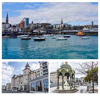
Dún Laoghaire is a suburban coastal town in County Dublin in Ireland. It is the administrative centre of the county of Dún Laoghaire–Rathdown. The town was built up alongside a small existing settlement following 1816 legislation that allowed the building of a major port to serve Dublin. It was known as Dunleary until it was renamed Kingstown in honour of King George IV's 1821 visit, and in 1920 was given its present name, the original Irish form from which "Dunleary" was anglicised. Over time, the town became a residential location, a seaside resort, the terminus of Ireland's first railway and the administrative centre of the former borough of Dún Laoghaire, and from 1994, of the county of Dún Laoghaire–Rathdown.

<span class="mw-page-title-main">Newtown Pery, Limerick</span> Neighbourhood of Limerick, Ireland

Newtown Pery is an area of central Limerick, Ireland, and forms the main city centre of the city. The district is known for its Georgian architectural heritage and is the core area of Limerick's Georgian Quarter. It is one of the three towns that make up modern-day Limerick City Centre, the other two being the older Englishtown and Irishtown, which date from the medieval period. Newtown Pery houses the largest collection of Georgian townhouses in Ireland outside of Dublin. In 1837, Samuel Lewis in his Topographical Dictionary of Ireland described Newtown Pery as "one of the handsomest towns in Ireland".

The following is a timeline of events pertaining to the Troubles in Dublin, Republic of Ireland.

<span class="mw-page-title-main">Cathedral Street, Dublin</span> Street in Dublin, Ireland

Cathedral Street is a street in central Dublin, Ireland, formerly known as Elephant Lane and Tyrone Place.

<span class="mw-page-title-main">Imperial Hotel, Dublin</span> Former hotel in Dublin, Ireland

The Imperial Hotel was a hotel in Dublin's principal thoroughfare, Sackville Street, until it was destroyed during the Easter Rising of 1916. The building comprised Clerys department store on the lower floors and the Imperial Hotel on upper floors situated opposite the General Post Office and Nelson's Pillar.
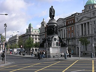
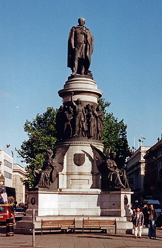
References

  1. "Refurbishment of the Riu Plaza The Gresham Dublin complete". Hospitality Net. Retrieved 14 August 2024.
  2. Murray 1981, pp. 34, 38–39.
  3. 1 2 3 "Transformation of the Gresham Hotel facade". PMAC. 8 March 2018. Retrieved 14 August 2024.
  4. https://arrow.tudublin.ie/cgi/viewcontent.cgi?article=1005&context=greshot [ bare URL ]
  5. O'Shea, Cormac (14 June 2016). "Seven places across Dublin depicted by James Joyce's works for Bloomsday". Irish Mirror. Retrieved 31 January 2021.
  6. https://iarc.ie/gresham-hotel-under-construction/ [ bare URL ]
  7. https://iarc.ie/gresham-hotel-under-construction/ [ bare URL ]
  8. O'Connor, Ulick (c. 1965). The Gresham Hotel, 1865-1965. Guy & Co., Ltd. p. 30.
  9. "Ryan Hotels change to Gresham Hotel Group". The Irish Times. Retrieved 14 August 2024.
  10. "The Gresham Hotel in Dublin Sold for €92 Million". Hotel News Resource. 16 September 2016. Retrieved 31 January 2021.
  11. Clarke, Vivienne; Power, Jack (5 January 2018). "Refurbishment plan means homeless families must leave Gresham Hotel". The Irish Times. Retrieved 5 January 2018.
  12. "Refurbishment of the Riu Plaza The Gresham Dublin complete". Hospitality Net. Retrieved 14 August 2024.

Sources