
The Alpine region of Switzerland, conventionally referred to as the Swiss Alps, represents a major natural feature of the country and is, along with the Swiss Plateau and the Swiss portion of the Jura Mountains, one of its three main physiographic regions. The Swiss Alps extend over both the Western Alps and the Eastern Alps, encompassing an area sometimes called Central Alps. While the northern ranges from the Bernese Alps to the Appenzell Alps are entirely in Switzerland, the southern ranges from the Mont Blanc massif to the Bernina massif are shared with other countries such as France, Italy, Austria and Liechtenstein.

Chamonix-Mont-Blanc, more commonly known simply as Chamonix (Chamôni), is a commune in the Haute-Savoie department in the Auvergne-Rhône-Alpes region in Southeastern France. It was the site of the first Winter Olympics, held in 1924.

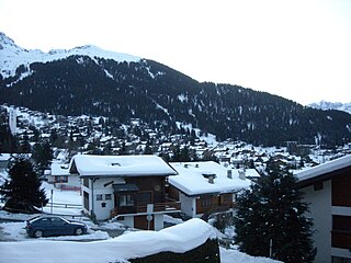
The Grisons or Graubünden, more formally the Canton of the Grisons or the Canton of Graubünden, is one of the twenty-six cantons of Switzerland. It has eleven districts, and its capital is Chur. The German name of the canton, Graubünden, translates as the "Grey Leagues", referring to the canton's origin in three local alliances, the Three Leagues. The other native names also refer to the Grey League: Grischùn in Sutsilvan, Grischun in the other forms of Romansh, and Grigioni in Italian. Rhaetia is the Latin name for the area. The Alpine ibex is the canton's heraldic symbol.

The Engadin or Engadine is a long high Alpine valley region in the eastern Swiss Alps in the canton of Graubünden in southeasternmost Switzerland with about 25,000 inhabitants. It follows the route of the Inn from its headwaters at Maloja Pass in the southwest running roughly northeast until the Inn flows into Austria, little less than one hundred kilometers downstream. The En/Inn subsequently flows at Passau into the Danube, making it the only Swiss river to drain into the Black Sea. The Engadine is protected by high mountain ranges on all sides and is famous for its sunny climate, beautiful landscapes and outdoor activities.

Valais, more formally, the Canton of Valais, is one of the 26 cantons forming the Swiss Confederation. It is composed of thirteen districts and its capital and largest city is Sion.

Gandria is both a quarter of the city of Lugano in the Swiss canton of Ticino, and a village on the northern shore of Lake Lugano, which forms the core of that quarter. Until 2004, the quarter of Gandria was an independent municipality, joining with Lugano in that year.

Engelberg is a village resort and a municipality in the canton of Obwalden in Switzerland. Alongside the central village of Engelberg, the municipality encompasses additional settlements, including Grafenort, Oberberg and Schwand.

Cortina d'Ampezzo sometimes abbreviated to simply Cortina, is a town and comune in the heart of the southern (Dolomitic) Alps in the province of Belluno, in the Veneto region of Northern Italy. Situated on the Boite river, in an alpine valley, it is an upscale summer and winter sport resort known for its skiing trails, scenery, accommodation, shops and après-ski scene, and for its jet set and Italian aristocratic crowd.

Adelboden is a mountain village and a municipality in Switzerland, located in the Frutigen-Niedersimmental administrative district in the Bernese Highlands.

Wengen is a mountain village in the Bernese Oberland of central Switzerland. Located in the canton of Bern at an elevation of 1,274 m (4,180 ft) above sea level, it is part of the Jungfrauregion and has approximately 1,300 year-round residents, which swells to 5,000 during summer and to 10,000 in the winter. Wengen hosts the classic Lauberhorn ski races of the FIS Alpine Ski World Cup in January.

Mürren is a traditional Walser mountain village in the Bernese Highlands of Switzerland, at an elevation of 1,638 metres (5,374 ft) above sea level. It cannot be reached by public road. It is also one of the popular tourist spots in Switzerland, and summer and winter are the seasons when Mürren becomes busy with tourists. The village features a view of the three towering mountains Eiger, Mönch, and Jungfrau. Mürren has a year-round population of 450, but has 2,000 hotel beds.

Thalwil is a municipality and town in the district of Horgen in the canton of Zürich in Switzerland. The municipality includes two parts: Thalwil and Gattikon.

Killiney is an affluent suburb in the southern coastal part of County Dublin, Ireland. It lies south of Dalkey, east and northeast of Ballybrack and Sallynoggin and north of Shankill. The place grew around the 11th century Killiney Church, and became a popular seaside resort in the 19th century. The area is notable for some famous residents, including two members of U2, and Enya.

Château-d'Œx is a municipality in the canton of Vaud in Switzerland. It is in the district of Riviera-Pays-d'Enhaut.

Livigno is a town, comune and a special-administered territory in the province of Sondrio, in the region of Lombardy, Italy, located in the Italian Alps, near the Swiss border.
Verbier is a village located in south-western Switzerland in the canton of Valais. It is a holiday resort and ski area in the Swiss Alps and is recognised as one of the premier off-piste resorts in the world. Some areas are covered with snow all year. Skiers have settled in the Verbier area in order to take advantage of the steep slopes, varied conditions, and resort culture.

Zuoz is a municipality in the Maloja Region in the Swiss canton of Graubünden.

Celerina/Schlarigna is a municipality in the Maloja Region in the Swiss canton of Graubünden.

Panni is a village and comune in the province of Foggia in the Apulia region of southeast Italy.

Bessans is a commune in the Savoie department in the Auvergne-Rhône-Alpes region in south-eastern France. It is located in the valley of Maurienne and crossed by the Arc river. Nestled in the center of a former glacial through, it is renowned for its large Nordic skiing domain in the winter and for its trekking and mountain climbing opportunities in the Summer. Surrounded by lush fauna and flora, the village is characterised by its rich heritage, where wall paintings, Baroque chapels, engraved stones and artisan sculptors are inextricably linked. The legend of the Devil of Bessans admirably describes the originality of this traditional culture that is still very much alive today.


