
The Lepontine Alps are a mountain range in the north-western part of the Alps. They are located in Switzerland and Italy.

Ticino, sometimes Tessin, officially the Republic and Canton of Ticino or less formally the Canton of Ticino, is one of the 26 cantons forming the Swiss Confederation. It is composed of eight districts and its capital city is Bellinzona. It is also traditionally divided into the Sopraceneri and the Sottoceneri, respectively north and south of Monte Ceneri. Red and blue are the colours of its flag.
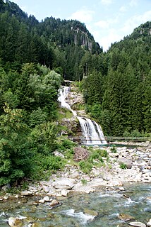
Faido is the capital of the district of Leventina in the Italian-speaking canton of Ticino in southern Switzerland.

Tremolite is a member of the amphibole group of silicate minerals with composition: Ca2(Mg5.0-4.5Fe2+0.0-0.5)Si8O22(OH)2. Tremolite forms by metamorphism of sediments rich in dolomite and quartz. Tremolite forms a series with actinolite and ferro-actinolite. Pure magnesium tremolite is creamy white, but the color grades to dark green with increasing iron content. It has a hardness on Mohs scale of 5 to 6. Nephrite, one of the two minerals of the gemstone jade, is a green variety of tremolite.

The Gotthard Pass or St. Gotthard Pass at 2,106 m (6,909 ft) is a mountain pass in the Alps traversing the Saint-Gotthard Massif and connecting northern with southern Switzerland. The pass lies between Airolo in the Italian-speaking canton of Ticino, and Andermatt in the German-speaking canton of Uri, and connects further Bellinzona to Lucerne, Basel, and Zurich. The Gotthard Pass lies at the heart of the Gotthard, a major transport axis of Europe, and it is crossed by three traffic tunnels, each being the world's longest at the time of their construction: the Gotthard Rail Tunnel (1882), the Gotthard Road Tunnel (1980) and the Gotthard Base Tunnel (2016). With the Lötschberg to the west, the Gotthard is one of the two main north-south routes through the Swiss Alps.

Marmolada is a mountain in northeastern Italy and the highest mountain of the Dolomites. It lies between the borders of Trentino and Veneto. The Marmolada is an ultra-prominent peak (Ultra).

The Valle Verzasca is a valley in the Locarno district of the Canton of Ticino, Switzerland. It comprises the municipalities of Mergoscia, Vogorno, Corippo, Lavertezzo, Brione, Gerra, Frasco, and Sonogno. As of 2004, the total population is 3,200. Mergoscia is at the geographical center of the Ticino, and none of the passes out of the valley cross cantonal or national borders. The valley is formed by the Verzasca River and is situated between the Leventina and the Maggia and culminates at Pizzo Barone.

Pizzo Campo Tencia is a mountain in the Lepontine Alps, which lies in the canton of Ticino, Switzerland. Pizzo Campo Tencia is the highest peak located entirely inside the canton.

Pizzo Rotondo is a mountain in the Lepontine Alps. At 3,190 metres above sea level, it is the highest mountain lying on the border between the cantons of Ticino and Valais, as well as the highest summit of the Lepontine Alps lying between Nufenen Pass and Lukmanier Pass.
Pizzo Campolungo is a mountain of the Lepontine Alps, overlooking Prato and Dalpe in the Leventina valley of the canton of Ticino. It lies just south of the Campolungo Pass.
Pizzo Massari is a mountain of the Lepontine Alps, overlooking Ambrì in the canton of Ticino. It is located on the chain separating the Val Lavizzara from the Leventina. The lakes Lago del Sambuco and Lago Tremorgio lie on its western and eastern side respectively.
Pizzo di Campello is a mountain of the Swiss Lepontine Alps, overlooking Faido in the canton of Ticino. It lies between the main Leventina valley and the valley of Blenio.

Pizzo Erra is a mountain of the Lepontine Alps, located in the Swiss canton of Ticino. It is located south of the pass of Basso di Nara, on the subrange that separates the main valley of Leventina from the valley of Blenio. At 2,416 metres (7,927 ft) above sea level, its summit can be accessed with trails from both western and eastern side.

Pizzo Coca is a mountain that straddles the Val Seriana and the Valtellina in Lombardy, Italy. It is the highest peak in the Bergamo Alps. Its height is 3,050 metres with a prominence height of 1,878 metres and a saddle of 1,172 metres. A post-glacial valley exists near a point called "ometto in sassi" at 2,400 meters.

Gribbio is an Italian-speaking village in Ticino, Switzerland, in the district of Chironico.
Pizzo Molare is a mountain of the Lepontine Alps, overlooking Faido in the Swiss canton of Ticino. It is located on the chain between the main Leventina valley and the valley of Blenio.
The Campolungo Pass is an Alpine pass connecting Fusio and Prat in the Swiss canton of Ticino. With a height of 2,318 metres above sea level, the Campolungo is the lowest pass connecting the valleys of Maggia and Leventina.

Pizzo Bianco is a mountain of the Pennine Alps, overlooking Macugnaga in the Italian region of Piedmont. It lies on the range north of the Punta Grober, between the Belvedere Glacier and the valley of Quarazza.

Carì is a village in the Swiss Alps, located in the canton of Ticino. The village is situated in the northern part of the canton, in the Leventina valley, above Faido. It belongs to the latter municipality.
The Passo di Predèlp (2,449 m, is a high mountain pass of the Lepontine Alps, located between the Valle Santa Maria and the Leventina, in Ticino.

