
The Brienzer Rothorn is a mountain of the Emmental Alps, in Switzerland. With an elevation of 2,350 metres (7,710 ft) above sea level, the Brienzer Rothorn is the highest summit of the range. To its west lies the Tannhorn, whilst to its east are Arnihaaggen, Höch Gumme and the Brünig Pass. On its south side it overlooks Lake Brienz, whilst to the north it looks out over the Waldemme valley.
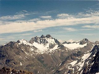
The Fluchthorn or Piz Fenga is a mountain in the Silvretta Alps, located on the border between Austria and Switzerland. With a height of 3,399 metres (11,152 ft) above sea level, it is the second highest summit of the Silvretta Alps. The Fluchthorn lies between the Jamtal (Tyrol) and the Val Fenga (Graubünden). It consists of three summits of which the southern one was the highest.
The Lägern is a wooded mountain of the Jura Mountains, stretching from Baden to Dielsdorf, about 15 km north-west of Zurich. The culminating point is located 1 km west of Hochwacht within the canton of Zurich, the border with the canton of Aargau running on a slightly lower summit named Burghorn.

Monte Generoso is a mountain of the Lugano Prealps, located on the border between Switzerland and Italy and between Lake Lugano and Lake Como. The western and southern flanks of the mountain lie in the Swiss canton of Ticino, whilst the north-eastern flanks are in the Italian region of Lombardy.

The Chasseral is a mountain of the Jura Mountains, overlooking Lake Biel in the Swiss canton of Bern. With an elevation of 1,606 metres above sea level, the Chasseral is the highest summit in the canton of Bern outside the Alps. It is also both the northernmost and easternmost mountain reaching over 1,500 metres in the Jura Mountains. West of the summit is located the Chasseral Ouest, where runs the border with the canton of Neuchâtel. The Chasseral Pass is located further on the west.

The Rochers de Naye is a mountain of the Swiss Alps, overlooking Lake Geneva near Montreux and Villeneuve, in the canton of Vaud. They lie on the range separating the basin of Lake Geneva from the valley of the Sarine, on the watershed between the Rhone and the Rhine. The mountain is partially located in the canton of Fribourg, the border between the two cantons culminating on a lower summit named Grande Chaux de Naye.

The Glärnisch is a mountain massif of the Schwyz Alps, overlooking the valley of the Linth in the Swiss canton of Glarus. It consists of several summits, of which the highest, Bächistock, is 2,915 metres above sea level. Until 2013, the highest point was considered to be an unnamed point with a summit cross at 2,914 metres. The other main summits are Vrenelisgärtli and the Ruchen.

The Wildhorn is a mountain of the Alps, straddling the border between the Swiss cantons of Bern and Valais. At 3,248 metres (10,656 ft) above sea level, it is the highest summit of the Bernese Alps west of the Gemmi Pass. It forms a large glaciated massif, about 10 km wide, extending between the Sanetsch Pass and the Rawil Pass. Along with the Muverans, the Diablerets and the Wildstrubel, the Wildhorn is one of the four distinct mountain massifs of the Bernese Alps that lie west of the Gemmi Pass. The massif of the Wildhorn is at the centre between the valleys of the Saane, Simme and the Rhone (Valais). It comprises several distinct summits, including the Arpelistock, Le Sérac, the Geltenhorn, the Sex Noir, the Sex Rouge, the Schnidehorn and the Six des Eaux Froides. The main crest is between the glaciers named Tungelgletscher and Glacier du Wildhorn. South of the main summit is the almost equally high summit of Mont Pucel. The Wildhorn is surrounded by several large mountain lakes: the Lac de Sénin, the Lauenensee, the Iffigsee, the Lac de Tseuzier and the Lac des Audannes. The Tungelgletscher, on the north-east face, was measured as 1.9 km in length in 1973.

The Plaine Morte Glacier is a glacier located at an elevation of 2,750 m (9,020 ft), in the canton of Bern above Lenk and in the Valais above Crans-Montana in Switzerland. The ice field, which covers 7.88 square kilometres (3.04 sq mi), is located below the mountain of Wildstrubel in the Bernese Alps. Its largest tongue is also called in German Rezligletscher or Rätzligletscher.

The Ringelspitz is a mountain of the Glarus Alps, located on the border between the Swiss cantons of St. Gallen and Graubünden. Reaching a height of 3,248 metres above sea level, it is the highest summit in the canton of St. Gallen. It is split between three municipalities: Pfäfers, Trin and Tamins (Graubünden).

Piz Terri is a mountain in the Lepontine Alps, located on the border between the cantons of Ticino and Graubünden. At 3,149 metres above sea level it is the highest summit lying on the chain between Greina and Soreda Pass. Piz Terri overlooks Lake Luzzone in Val Blenio on its west side, Val Sumvitg on its north side and Lumnezia on its east side. Close localities are Olivone and Vrin (Lumnezia).

The Cornettes de Bise is a mountain in the Chablais Alps, overlooking Lake Geneva. At 2,432 metres above sea level, it is the highest summit of the subrange running from Pas de Morgins to Lake Geneva. The mountain is located on the border between France (west) and Switzerland (east).

Piz Medel is a mountain in the Lepontine Alps, located on the border between the cantons of Ticino and Graubünden. At 3,210 metres (10,531 ft) above sea level it is the highest summit on the chain between Lukmanier Pass and Crap la Crusch. The mountain overlooks the Greina, an important pass connecting the cantons of Graubünden and Ticino.

Piz Pisoc is a mountain in the Sesvenna Range of the Alps, overlooking Tarasp in the Swiss canton of Graubünden. With an elevation of 3,173 metres above sea level, it is the highest summit of the Sesvenna Range west of Pass Costainas and the second highest summit of the whole range.

Monte Tamaro is a mountain of the Lugano Prealps, overlooking Lake Maggiore in the Swiss canton of Ticino. Reaching a height of 1,962 metres above sea level, it is the highest summit of the chain located between Lake Maggiore and Lake Lugano, which also includes Monte Lema. It is also the most prominent summit of the canton.

Mont Tendre is a mountain of the Jura, located between the valley of Joux and the basin of Lake Geneva in the canton of Vaud. With an elevation of 1,679 metres above sea level, it is the highest summit of the Swiss portion of the Jura Mountains and, therefore, the highest summit of Switzerland outside the Alps. It is also the most isolated mountain of the canton. It is found in the community of Montricher.

The Wildspitz is the highest summit of the Rossberg, a mountain of the Schwyzer Alps, located on the border between the Swiss cantons of Zug and Schwyz. Reaching a height of 1,580 metres above sea level, it is the highest summit in the canton of Zug.

The Hasenmatt is a mountain of the Jura range, located north of Grenchen and Solothurn in the Swiss canton of Solothurn. Reaching a height of 1,445 metres above sea level, it is the highest summit in the canton of Solothurn. The Hasenmatt is also the easternmost summit above 1,400 metres of the Jura Mountains.

Monte Rogoria is a mountain of the Lugano Prealps, located on the border between Switzerland and Italy, north of Astano, at the foot of the Monte Lema. The summit and the majority of the mountain are in the Swiss canton of Ticino, whilst a part of the north-western flank lies in the Italian region of Lombardy. It has an elevation of 1,184 metres above sea level. The view from the summit of the mountain encompasses the Lake Maggiore, the Borromean Islands and the Monte Rosa massif. There is no official hiking trail leading to the summit itself, but there are trails to the mountain pass Forcola respectively Passo di Monte Faëta at an altitude of 1,117 metres located close to the summit plateau. Starting points are: Astano, Miglieglia and Dumenza.

