
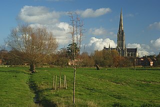
Salisbury is a cathedral city and civil parish in Wiltshire, England with a population of 41,820, at the confluence of the rivers Avon, Nadder and Bourne. The city is approximately 20 miles from Southampton and 30 miles from Bath.

Trowbridge is the county town of Wiltshire, England; situated on the River Biss in the west of the county, close to the border with Somerset. The town lies 8 miles (13 km) south-east of Bath, 31 miles (50 km) south-west of Swindon and 20 miles (32 km) south-east of Bristol. The parish had a population of 37,169 in 2021.

Tidworth is a garrison town and civil parish in south-east Wiltshire, England, on the eastern edge of Salisbury Plain. Lying on both sides of the A338 about 3+1⁄2 miles (5.6 km) north of the A303 primary route, the town is approximately 8 miles (13 km) west of Andover, 12 miles (19 km) south of Marlborough, and 13 miles (21 km) north by north-east of Salisbury. The population of the parish at the 2011 census was approximately 10,600.

Easton Royal is a village in the civil parish of Easton in Wiltshire, England, about 3 miles (5 km) east of Pewsey and 5 miles (8 km) south of Marlborough. The village was the location of Easton Priory from 1234 to 1536. The village mistakenly gained the Royal suffix in 1838 and the name Easton Royal has been in general use since the 1850s.

Fonthill Gifford is a village and civil parish in Wiltshire, England, to the north of the Nadder valley, 14 miles (23 km) west of Salisbury.

Grafton is a civil parish in Wiltshire, England, in the Vale of Pewsey about 7 miles (11 km) southeast of Marlborough. Its main settlement is the village of East Grafton, on the A338 Burbage - Hungerford road; the parish includes the village of Wilton and the hamlets of West Grafton, Marten and Wexcombe.

Dilton Marsh is a village and civil parish in the far west of the county of Wiltshire, in the southwest of England. The village is about 1.5 miles (2.4 km) southwest of the centre of the town of Westbury; Dilton Marsh remains a distinct settlement with its own character and community, bounded and separated from Westbury Leigh by the Biss Brook.

The Diocese of Salisbury is a Church of England diocese in the south of England, within the ecclesiastical Province of Canterbury. The diocese covers the historic county of Dorset, and most of Wiltshire. The diocese is led by Stephen Lake, Bishop of Salisbury, and by the diocesan synod. The bishop's seat is at Salisbury Cathedral.

Winterslow is a civil parish with a population of around 2,000, about 6 miles (10 km) northeast of Salisbury in Wiltshire, England, and lying south of the A30 London Road. It is sited on the Roman road between Old Sarum and Winchester.
Berwick St Leonard is a small village and civil parish in Wiltshire, England, about 8 miles (13 km) southeast of Warminster and 14 miles (23 km) west of Salisbury.

Boyton is a village and civil parish in Wiltshire, England. It lies in the Wylye Valley within Salisbury Plain, about 6 miles (10 km) south-east of Warminster and 13 miles (21 km) north-west of Salisbury. The parish includes the village of Corton.

Bulford is a village and civil parish in Wiltshire, England, near Salisbury Plain. The village is close to Durrington and about 1.5 miles (2.4 km) north of the town of Amesbury. The Bulford Camp army base is separate from the village but within the parish.

East Grimstead is a village in the civil parish of Grimstead, on the River Dun in Wiltshire, England, about 5 miles (8.0 km) east of Salisbury. The village has about 70 households and no shops, public houses or schools.

Chitterne is a village and civil parish in the county of Wiltshire, in the south west of England. The village lies in the middle of Salisbury Plain, about 7 miles (11 km) east of the town of Warminster.

West Grimstead is a village in the civil parish of Grimstead, on the River Dun in Wiltshire, England, about 4.5 miles (7.2 km) southeast of Salisbury.
Harnham is a suburb of the city of Salisbury in Wiltshire, England, centred about 0.6 miles (1 km) south of Salisbury Cathedral and across the River Avon. Harnham is split into the areas of West Harnham and East Harnham.
West Dean is a village and civil parish in southeast Wiltshire, England; the Wiltshire/Hampshire border runs through the eastern part of the village. The village is on the River Dun, about 7 miles (11 km) east of Salisbury and the same distance northwest of Romsey.
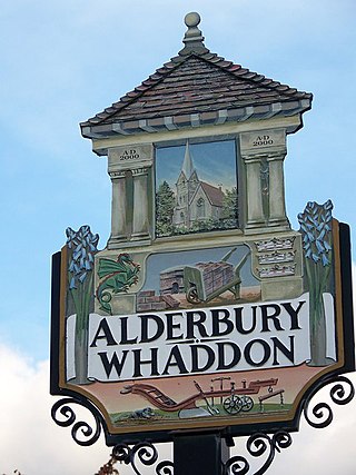
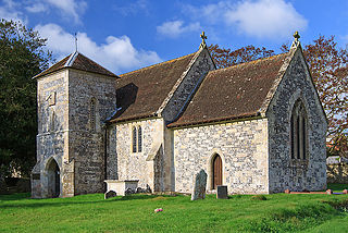
Alderbury is a village and civil parish in Wiltshire, England, in the south of the county around 3 miles (5 km) southeast of Salisbury.

Laverstock is a village and civil parish on the north-east and east outskirts of Salisbury in the ceremonial county of Wiltshire, England. The parish is shaped like a figure 7 and incorporates Ford hamlet, the eastern half of the former manor of Milford, the area near the ancient settlement of Old Sarum, and part of the Hampton Park district on the edge of Salisbury.

Farley is a village in southeast Wiltshire, England, about 5 miles (8.0 km) east of Salisbury.

