Großengottern

Last updated • 4 min readFrom Wikipedia, The Free Encyclopedia

Großengottern
Rathaus in Grossengottern.JPG
Town hall
Wappen Grossengottern.png
Location of Großengottern
Grossengottern
Germany adm location map.svg
Red pog.svg
Großengottern
Thuringia location map.svg
Red pog.svg
Großengottern
Coordinates: 51°9′N10°35′E / 51.150°N 10.583°E / 51.150; 10.583 Coordinates: 51°9′N10°35′E / 51.150°N 10.583°E / 51.150; 10.583
Country Germany
State Thuringia
District Unstrut-Hainich-Kreis
Municipality Unstrut-Hainich
First mentioned811 or 1253
Area
  Total19.26 km2 (7.44 sq mi)
Elevation
187 m (614 ft)
Population
 (2017-12-31)
  Total2,286
  Density120/km2 (310/sq mi)
Time zone UTC+01:00 (CET)
  Summer (DST) UTC+02:00 (CEST)
Postal codes
99991
Dialling codes 036022
Website grossengottern.com

Großengottern is a village and a former municipality in the Unstrut-Hainich-Kreis district of Thuringia, Germany. Since 1 January 2019, it is part of the municipality of Unstrut-Hainich.

Contents

Geography

Großengottern is located in the northern Thuringian basin between the towns of Mühlhausen and Bad Langensalza. The village of Großengottern lies in the area of the Inner Thuringian hilly farmland, the north and the east of the village, the Gotternsches Ried, in the Unstrut floodplain between Mühlhausen and Bad Langensalza. The highest elevation is 220 metres (720 ft) above sea level (NN) at Kammerforster Weg to the west of the village, the lowest at about 173 metres (568 ft) above sea level (NN) on the Unstrut in the far east of the terrain. Other elevations are the two former undercut slope areas of the Unstrut, the 193.3-metre-high (634 ft)Hopfenberg hill to the north-east and the 193.6-metre-high (635 ft)Schalkenberg to the south-east of the village. The Gottern area is mainly used for agriculture, with arable farming predominating. Poplar forests are found on the southern edge of the Gotternsches Ried; the Großengottern dam is a reservoir originally built for the irrigation of the fields.

History

The village was first mentioned in a document in 811; however, according to Wolfgang Kahl, the first documentary mention of Großengottern took place on 13 March 1253. [1]

There was once a castle site in the area of the Walpurgis' cemetery. The church and the cemetery are most likely located on the site of the medieval manor castle. The gatehouse from the cemetery in 1580 and the church tower, built in 1494, still show the fortified nature of the area. [2]

The Mülverstedt convent of the Hermits of Saint William acquired a plot of land in Großengottern in the first half of the 14th century in order to set up a hospital here. The village chapel of St Andrew probably emerged from this facility around 1347. In the 15th century, the hospital was described as a leprosarium; it was one of the 39 leprosariums known so far in Thuringia. [3] The complex was further altered by rebuilding in the 18th and 19th centuries. The Lords of Hopffgarten had converted the estate into an old people's home. A woman known as Katzenbertha ("Cats Bertha") can be traced as the last resident. From 1958 to 1990, a local history museum was housed in the former hospital. [4]

In the Late Middle Ages and Early Modern Period, the Lords of Seebach held the office of Schultheiß (mayor) in Großengottern along with market rights and a castle fiefdom.

Until 1815, the village belonged to the Electoral Saxon district of Langensalza and, after its cession to Prussia, from 1816 to 1944 to the district of Langensalza in the Province of Saxony.

On 4 March 1949, a four-engine US supply plane for the Berlin Airlift exploded and crashed between Großengottern and Heroldishausen. Four of the five crew members were able to save themselves with parachutes, but Lieutenant R. C. Stephens lost his life. He was honoured in 1999 by erecting a memorial plaque near the crash site on a road. During the time of the GDR, the crash was kept secret as far as possible. [5]

Since 1993, Großengottern was a member and administrative seat of the Unstrut-Hainich administrative association, whose member municipalities (except of Schönstedt) merged to form the rural municipality of Unstrut-Hainich on 1 January 2019. [6]

Culture and sights

Related Research Articles

Unstrut-Hainich-Kreis is a Kreis (district) in the north of Thuringia, Germany. Neighboring districts are the districts Eichsfeld, Kyffhäuserkreis, Sömmerda, Gotha, Wartburgkreis and the district Werra-Meißner in Hesse.

Wartburgkreis is a Kreis (district) in the west of Thuringia, Germany. Neighboring districts are the districts Unstrut-Hainich-Kreis, Gotha, Schmalkalden-Meiningen, and the districts Fulda, Hersfeld-Rotenburg and Werra-Meißner-Kreis in Hesse.

<span class="mw-page-title-main">Bad Langensalza</span> Town in Thuringia, Germany

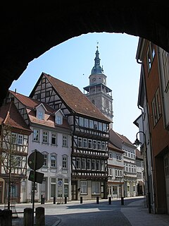
Bad Langensalza is a spa town of 17,500 inhabitants in the Unstrut-Hainich district, Thuringia, central Germany.

<span class="mw-page-title-main">Mühlhausen</span> Town in Thuringia, Germany

Mühlhausen is a city in the north-west of Thuringia, Germany, 5 km north of Niederdorla, the country's geographical centre, 50 km north-west of Erfurt, 65 km east of Kassel and 50 km south-east of Göttingen.

<span class="mw-page-title-main">Tottleben</span> Municipality in Thuringia, Germany

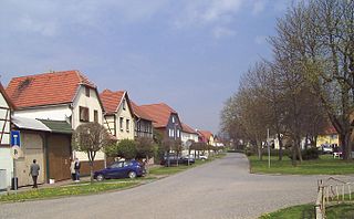
Tottleben is a municipality in the Unstrut-Hainich-Kreis district of Thuringia, Germany.

<span class="mw-page-title-main">Weinbergen</span> Municipality in Thuringia, Germany

Weinbergen is a former municipality in the Unstrut-Hainich-Kreis district of Thuringia, Germany. It was created on 30 June 1994 in the course of a territorial reform by the merger of the municipalities of Bollstedt, Grabe, Höngeda and Seebach. On 1 January 2019, Weinbergen was dissolved, and the four villages which it consisted of were incorporated into the territory of the town of Mühlhausen. The Seebach State Bird Protection Station, located in the former municipality, is known beyond the region.

<span class="mw-page-title-main">Thuringian Basin</span>

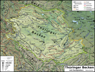
The Thuringian Basin is a depression in the central and northwest part of Thuringia in Germany which is crossed by several rivers, the longest of which is the Unstrut. It stretches about 60 kilometres (37 mi) from north to south and around 120 kilometres (75 mi) from east to west. Its height varies from about 150 to 250 m above sea level (NN).

<span class="mw-page-title-main">Unstrut-Hainich</span> Municipality in Thuringia, Germany

Unstrut-Hainich is a municipality in the district Unstrut-Hainich-Kreis, in Thuringia, Germany. It was created with effect from 1 January 2019 by the merger of the former municipalities of Altengottern, Flarchheim, Großengottern, Heroldishausen, Mülverstedt and Weberstedt. The name refers to the river Unstrut and the hill chain Hainich.

<span class="mw-page-title-main">Mühlhausen (Thür) station</span>

Mühlhausen (Thür) station is a passenger station in the Unstrut-Hainich district and the only station in Mühlhausen in the German state of Thuringia. It is located east of the centre of Mühlhausen in the valley of the Unstrut.

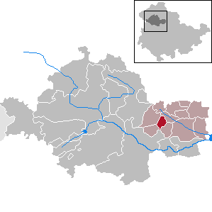
Unstrut-Hainich-Kreis II is an electoral constituency represented in the Landtag of Thuringia. It elects one member via first-past-the-post voting. Under the current constituency numbering system, it is designated as constituency 9. It covers the central, southern, and eastern part of Unstrut-Hainich-Kreis.

<span class="mw-page-title-main">Felchta</span> Ortsteil of Mühlhausen in Thuringia, Germany

Felchta is a village and quarter of the town of Mühlhausen in Thuringia, central Germany.

<span class="mw-page-title-main">Höngeda</span> Ortsteil of Mühlhausen in Thuringia, Germany

Höngeda is a village and quarter of the town of Mühlhausen in Thuringia, central Germany.

<span class="mw-page-title-main">Windeberg</span> Ortsteil of Mühlhausen in Thuringia, Germany

Windeberg is a village and quarter of the town of Mühlhausen in Thuringia, central Germany.

<span class="mw-page-title-main">Saalfeld, Mühlhausen</span> Ortsteil of Mühlhausen in Thuringia, Germany

Saalfeld is a village and a quarter of the town of Mühlhausen in Thuringia, central Germany.

<span class="mw-page-title-main">Bollstedt</span> Ortsteil of Mühlhausen in Thuringia, Germany

Bollstedt is a village and a quarter of the town of Mühlhausen in Thuringia, central Germany, situated on the left bank of the Unstrut.

<span class="mw-page-title-main">Görmar</span> Ortsteil of Mühlhausen in Thuringia, Germany

Görmar is a village and a quarter of the town of Mühlhausen in Thuringia, central Germany.

<span class="mw-page-title-main">Grabe, Mühlhausen</span> Ortsteil of Mühlhausen in Thuringia, Germany

Grabe is a village and a quarter of the town of Mühlhausen in Thuringia, central Germany. It consists of the settlements Kleingrabe and Großgrabe.

<span class="mw-page-title-main">Seebach, Mühlhausen</span> Ortsteil of Mühlhausen in Thuringia, Germany

Seebach is a village and a rural quarter of the town of Mühlhausen in Thuringia, central Germany. It lies on the right side of the Unstrut river.

<span class="mw-page-title-main">Thamsbrück</span> Ortsteil of Bad Langensalza in Thuringia, Germany

Thamsbrück is a quarter of the town of Bad Langensalza in Thuringia, central Germany, about 35 kilometres (22 mi) northwest of Erfurt, with 940 inhabitants. The town, which has been independent since 1206, was incorporated into Bad Langensalza in 1994.

References

  1. Kahl, Wolfgang (2010). Ersterwähnung Thüringer Städte und Dörfer. Ein Handbuch (in German) (5th ed.). Bad Langensalza: Rockstuhl. p. 101. ISBN   978-3-86777-202-0.
  2. Köhler, Michael (2001). Thüringer Burgen und befestigte vor- und frühgeschichtliche Wohnplätze (in German). Jena: Jenzig-Verlag. p. 263. ISBN   3-910141-43-9.
  3. Rossner, Christiane (2015). "Trommeln für die kleinste Hütte. Das Hospitalensemble in Großengottern könnte bald nicht mehr vollständig sein". Monumente (in German). 25 (2): 22–26.
  4. "Hospital St. Andreas" (in German). Deutsche Stiftung Denkmalschutz . Retrieved 6 March 2018.
  5. Götze, Claudia (3 March 2014). "Rosinenbomber sind in der Erinnerung weiterhin verankert. Auch 65 Jahre nach Absturz ist humanitäre Hilfe amerikanischer Luftbrücken-Piloten nicht vergessen". Thüringische Landeszeitung (in German).
  6. "Thüringer Gesetz- und Verordnungsblatt Nr. 14/2018" (PDF) (in German). p. 804. Retrieved 2 June 2022.
  7. VG Unstrut-Hainich Großengottern. Dorfkirche St. Andreas. Moment. Das Kulturmagazin für das Hainichland (in German). Vol. 3. Bad Langensalza: Sons Medien. 2005. pp. 23–24. ZDB-ID   2192647-5.