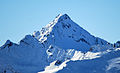
| Grubenwand | |
|---|---|
 Northeast aspect | |
| Highest point | |
| Elevation | 3,173 m (10,410 ft) [1] |
| Prominence | 224 m (735 ft) [1] |
| Parent peak | Gleirscher Fernerkogel [1] |
| Isolation | 1.67 km (1.04 mi) [2] |
| Coordinates | 47°07′09″N11°05′10″E / 47.11918°N 11.086033°E [1] |
| Geography | |
 Grubenwand Location in Austria 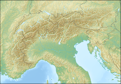 Grubenwand Grubenwand (Alps) | |
 | |
| Interactive map of Grubenwand | |
| Country | Austria |
| State | Tyrol |
| Parent range | Alps Stubai Alps |
| Topo map(s) | Tabacco 31 Stubaier Alpen, Sellrain – Kühtai |
| Geology | |
| Rock type | Schist |
| Climbing | |
| Easiest route | Northeast Ridge |
Grubenwand is a mountain in the state of Tyrol in Austria.