Gschwend, Baden-Württemberg

Last updated • 9 min readFrom Wikipedia, The Free Encyclopedia
Gschwend
DEU Gschwend COA.svg
Location of Gschwend within Ostalbkreis district
Gschwend in AA.svgEllenbergEschachEssingenGschwendHüttlingenHüttlingenLorchRosenbergRuppertshofenWesthausen
Germany adm location map.svg
Red pog.svg
Gschwend
Baden-Wuerttemberg location map.svg
Red pog.svg
Gschwend
Coordinates: 48°56′03″N09°44′36″E / 48.93417°N 9.74333°E / 48.93417; 9.74333
Country Germany
State Baden-Württemberg
Admin. region Stuttgart
District Ostalbkreis
Government
   Mayor (201624) Christoph Hald [1]
Area
  Total54.50 km2 (21.04 sq mi)
Elevation
484 m (1,588 ft)
Population
 (2022-12-31) [2]
  Total4,933
  Density91/km2 (230/sq mi)
Time zone UTC+01:00 (CET)
  Summer (DST) UTC+02:00 (CEST)
Postal codes
74417
Dialling codes 07972
Vehicle registration AA
Website www.gschwend.de

Gschwend is a town in the German state of Baden-Württemberg, in Ostalbkreis district.

Contents

Geography

Geographical Location

Village center of the main town Gschwend Gschwend 2018 03.jpg
Village center of the main town Gschwend

Gschwend has a share in the three natural regions Eastern Swabian Foothills (Östliches Albvorland), Schurwald and Welzheimer Wald, as well as the Swabian-Franconian Mountain Forests (Schwäbisch-Fränkische Waldberge), all of which belong to the Swabian Keuper-Lias Lands. [3] The municipality lies between the Welzheimer Wald and Frickenhofer Höhe in the Swabian-Franconian Forest Nature Park, on the "Gschwender" Rot, a left tributary of the Lein river.

Neighboring Municipalities

The municipality borders Fichtenberg to the northwest, the town of Gaildorf to the north, Sulzbach-Laufen to the east, all in the Schwäbisch Hall district; Eschach to the southeast, Ruppertshofen to the south and Spraitbach to the southwest, both in the Ostalbkreis district. To the southwest Gschwend borders Alfdorf, and to the west Kaisersbach and Murrhardt, all in the Rems-Murr district.

Municipal Subdivisions

Historical oil mill stamping works in the Brandhofer mill near Gschwend Brandhofer Olmuhle.jpg
Historical oil mill stamping works in the Brandhöfer mill near Gschwend

The municipality of Gschwend, with the formerly independent municipalities of Altersberg and Frickenhofen, consists of 85 villages, hamlets, farms and houses.

To the former municipality of Altersberg belong:

To the former municipality of Frickenhofen belong:

To the municipality of Gschwend before the municipal reform of the 1970s belong:

History

Until the 18th Century

Frickenhofen, first mentioned in a document in 1293, is the oldest documented locality in the municipality. However, it is assumed that the settlement of Gschwend has existed since the middle of the 12th century. Not much later, the forest around Gschwend was cleared. A special type of clearing was called "Schwenden", which gave Gschwend its name. In this process, the bark of the trees was peeled off, causing them to wither and then either die or be easily ignited and burnt. The flame in the Gschwend coat of arms refers to this burning.

Initially Gschwend was a rather insignificant settlement, but developed into a rural trade center due to its favorable location at the intersection of the roads from Schwäbisch Hall via Gaildorf to Gmünd (the Salt Road from Hall to the south, today's Federal Highway 298) and from Welzheim to Aalen (Cannstatter Road). In the 16th century, the court in Seelach was relocated to Gschwend. There were large cattle markets and annual fairs have been held since 1760. In 1857, a village fire occurred in Gschwend, destroying dozens of buildings.

Administrative History

Since 1374, Gschwend belonged to the Amt (district) of Gaildorf under the Schenken of Limpurg. In 1806, Gschwend fell to the Kingdom of Württemberg. With the implementation of the new administrative structure, the present-day municipal area of Gschwend was assigned to the Oberamt (regional district) of Gaildorf. During the district reform in Nazi-era Württemberg, Gschwend became part of Backnang district in 1938. In 1945, the municipal area became part of the American occupation zone and thus belonged to the newly founded state of Württemberg-Baden, which merged into the present state of Baden-Württemberg in 1952.

Incorporations and District Reform 1971 to 1973

On 1 August 1971, the previously independent municipality of Frickenhofen was incorporated into Gschwend, followed by the incorporation of Altersberg on 1 January 1972. Honkling and Wildgarten were reassigned from Unterrot to Gschwend on 1 April 1972. [6] When Backnang district was dissolved in the district reform of 1973, the municipality of Gschwend became part of the Ostalbkreis district, while the rest of the former Limpurg lands fell to the neighboring Schwäbisch Hall district.

Religions

Since the Reformation, Gschwend has been predominantly Protestant. In addition to four Protestant congregations, there is also a Roman Catholic and a New Apostolic congregation.

Politics

Mayor

The mayor of the municipality has been Christoph Hald (CDU) since 2016. He succeeded Rosalinde Kottmann, who was the first woman elected to this office in the Ostalbkreis district when she was elected in 2000. In the mayoral election on 14 April 2024, Jochen Ziehr prevailed with 55.2% of the votes against incumbent Hald, who received 44.6% of the votes. Ziehr will assume office on 15 July 2024. [7]

Coat of Arms

Coat of arms of Gschwend DEU Gschwend COA.svg
Coat of arms of Gschwend

In gold a red flame with three tongues, accompanied in chief dexter and base sinister by a green fir tree each.

As a canting arms, the coat of arms refers to the place name. "Gschwendeter" means "cleared by burning".

The municipal flag is red-yellow.

Around 1820, the Schultheißenamt (municipal office) used a seal showing a crab on a high oval shield. The meaning of this seal image is not recorded, and the seal later fell into oblivion. In 1926, the Archive Directorate in Stuttgart proposed a burning branch as a canting arms. The Schultheißenamt then adopted the present coat of arms.

On 26 May 1956, the municipality was granted its current coat of arms and flag by the Interior Ministry of Baden-Württemberg. [8] [9]

Coats of Arms of the Districts

Sights

Hagberg Tower near Gschwend Hagbergturm-2010.jpg
Hagberg Tower near Gschwend
Devil's Pulpit on the north side of Hohe Tannen near Rotenhar Teufelskanzel.jpg
Devil's Pulpit on the north side of Hohe Tannen near Rotenhar
Church in Frickenhofen Gschwend 2018 18.jpg
Church in Frickenhofen
Atonement Cross near Frickenhofen Suehnekreuz Frickenhofen.jpg
Atonement Cross near Frickenhofen

Gschwend lies along the Idyllische Straße, which passes by many sights. The forest experience trail weiterweg is located on the road from Rotenhar to Schönberg. It combines an art trail and a contemplative path with ten stations. [10] [11]

Museums

The local heritage museum is located in the former school and town hall building in Horlachen.

Buildings

Protestant Parish Church (formerly St. Nikolaus) in Frickenhofen. Built in 1743 in place of a Gothic predecessor church that burned down in 1634. Memorial plaque to Pastor Wolfgang Kirschenbeisser next to the church entrance.

Natural Monuments

Economy and Infrastructure

Transport

Gschwend is connected to the regional road network via Federal Highway 298 (Gaildorf–Schwäbisch Gmünd).

Companies based locally

The wood-based panel manufacturer Pfleiderer operated a particleboard plant in Gschwend. After "having been completely on short-time work for 13 months already", it was closed in October 2010.

Education

Gschwend is home to the Heinrich-Prescher-School, an elementary and secondary modern school with a secondary technical school branch. In the district of Frickenhofen, there is another elementary school based on the Montessori method of education. The private vocational school for circus arts CircArtive is also located in Gschwend. In addition, there are three municipal and three church-run kindergartens.

Notable people

Customs/Traditions

Harvest Wagon

Every year at the beginning of the harvest season, usually on the first weekend of August, a decorated harvest wagon with the first sheaves is pulled by horses in a festive procession of children and accompanied by the ringing of bells to the church in the marketplace. This tradition dates back to 1817. [14] At that time, after the great famine of 1816, it was decided to ceremoniously escort the first harvest wagon to the church.

Gschwend is, along with Essingen, one of the few communities that still maintains this tradition today with great participation from the population.

Cattle Market

After the great fire of 1857, the people of Gschwend took the opportunity to completely redesign their town center. They leveled a large rectangle at the intersection of the main thoroughfares and created a new, spacious marketplace, as the previous condition was not ideal for the cattle market. The town had already received the "right to two annual markets" in 1760, with a third added in 1776. This was another milestone in the development into today's central community, after being designated as an administrative center in the 16th century. The markets made Gschwend an agricultural center and promoted trade and commerce. They were well-known and well-attended far and wide. Between 500 and 1,000 cattle were driven there at the time, and in February 1887 there were even 1,425. Although the Gschwend markets can no longer boast such numbers in the course of motorization and technologization, they are still among the most important in northern Württemberg.

Further reading

Related Research Articles

Schwäbisch Hall is a Landkreis (district) in the northeast of Baden-Württemberg, Germany. Neighboring districts are Main-Tauber, the Bavarian district Ansbach, Ostalbkreis, Rems-Murr, and Hohenlohe.

<span class="mw-page-title-main">Fellbach</span> Town in Baden-Württemberg, Germany

Fellbach is a mid-sized town on the north-east edge of Stuttgart in Baden-Württemberg, Germany. With a population of approximately 45.430 as of December 2020 is the second largest town in the District Rems-Murr-Kreis. The area of the town is 27.7 km2 (10.7 sq mi).

<span class="mw-page-title-main">Adelmannsfelden</span> Municipality in Baden-Württemberg, Germany

Adelmannsfelden is a municipality in the German state of Baden-Württemberg, in Ostalbkreis district.

<span class="mw-page-title-main">Abtsgmünd</span> Municipality in Baden-Württemberg, Germany

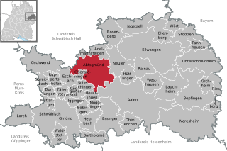
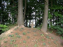
Abtsgmünd is a municipality in the German state of Baden-Württemberg, in Ostalbkreis district. Abtsgmünd is located at the confluence of two streams, the Lein and the Kocher. The large area municipality consists of the main town of Abtsgmünd as well as the five districts of Neubronn, Laubach, Untergröningen, Hohenstadt and Pommertsweiler and their associated villages and hamlets. The municipality is a state-recognized recreation area in the Swabian-Franconian Forest Nature Park.

<span class="mw-page-title-main">Eschach, Germany</span> Municipality in Baden-Württemberg, Germany

Eschach is a municipality in the German state of Baden-Württemberg, in Ostalbkreis district.

<span class="mw-page-title-main">Neuler</span> Municipality in Baden-Württemberg, Germany

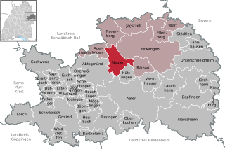
Neuler is a town in the German state of Baden-Württemberg, in Ostalbkreis district.

<span class="mw-page-title-main">Neidlingen</span> German municipality

Neidlingen is a municipality in the district of Esslingen, in Baden-Württemberg, Germany.

<span class="mw-page-title-main">Albershausen</span> Municipality in Baden-Württemberg, Germany

Albershausen is a municipality in the district of Göppingen in Baden-Württemberg in southern Germany.

<span class="mw-page-title-main">Böhmenkirch</span> German municipality

Böhmenkirch is a municipality in the district of Göppingen in Baden-Württemberg, Germany.

<span class="mw-page-title-main">Eschenbach (Göppingen)</span> Municipality in Baden-Württemberg, Germany

Eschenbach is a municipality in the district of Göppingen in Baden-Württemberg in Germany.

<span class="mw-page-title-main">Hattenhofen, Baden-Württemberg</span> Municipality in Baden-Württemberg, Germany

Hattenhofen is a municipality in the district of Göppingen in Baden-Württemberg in southern Germany.

<span class="mw-page-title-main">Ottenbach, Baden-Württemberg</span> Municipality in Baden-Württemberg, Germany

Ottenbach is a municipality in the district of Göppingen in Baden-Württemberg in southern Germany.

<span class="mw-page-title-main">Zell unter Aichelberg</span> Municipality in Baden-Württemberg, Germany

Zell unter Aichelberg is a municipality in the district of Göppingen in Baden-Württemberg in southern Germany.

<span class="mw-page-title-main">Plüderhausen</span> Municipality in Baden-Württemberg, Germany

Plüderhausen is a municipality east of Schorndorf in the Rems-Murr district in Baden-Württemberg, Germany. It belongs to the Stuttgart Metropolitan Region.

<span class="mw-page-title-main">Frankenhardt</span> Municipality in Baden-Württemberg, Germany

Frankenhardt is a rural Gemeinde (municipality) in the district of Schwäbisch Hall in Baden-Württemberg in Germany. It consists of thirty-nine villages, hamlets and other settlements. The largest village is Honhardt, followed by Gründelhardt and Oberspeltach. The township lies about twenty kilometres east of the town of Schwäbisch Hall.

<span class="mw-page-title-main">Hüttlingen, Baden-Württemberg</span> Municipality in Baden-Württemberg, Germany

Hüttlingen is a municipality in the German state of Baden-Württemberg, in Ostalbkreis district.

<span class="mw-page-title-main">Dürnau, Göppingen</span> Municipality in Baden-Württemberg, Germany

Dürnau is a municipality in the district of Göppingen in Baden-Württemberg in southern Germany.

<span class="mw-page-title-main">Bisingen</span> German municipality

Bisingen is a municipality in the Zollernalbkreis district of Baden-Württemberg, Germany.

<span class="mw-page-title-main">Beutelsbach (Weinstadt)</span> Stadtteil of Weinstadt in Baden-Württemberg, Germany

Beutelsbach is a town district or Stadtteil within the town of Weinstadt in Rems-Murr district, Baden-Württemberg, Germany. The Stadtteil has a population of 8,464 and an elevation of 236 m above sea level.

<span class="mw-page-title-main">Frickenhofer Höhe</span>

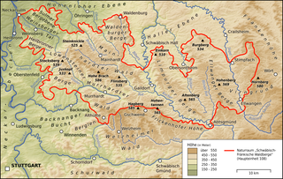
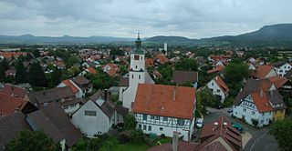
The Frickenhofer Höhe is hill range, up to 565.4 m above sea level (NHN), in the German state of Baden-Württemberg. Most of the range falls within the county of im Ostalbkreis but its northern spurs reach into Schwäbisch Hall. The elongated plateau-like region is named after the village of Frickenhofen, a settlement on the narrow northwest tip of the hills in the municipality of Gschwend.

References

  1. Aktuelle Wahlergebnisse, Staatsanzeiger, accessed 13 September 2021.
  2. "Bevölkerung nach Nationalität und Geschlecht am 31. Dezember 2022" [Population by nationality and sex as of December 31, 2022](CSV) (in German). Statistisches Landesamt Baden-Württemberg. June 2023.
  3. Naturräume Baden-Württembergs. Landesanstalt für Umwelt, Messungen und Naturschutz Baden-Württemberg, Stuttgart 2009.
  4. 1 2 Statistisches Bundesamt (editor): Historisches Gemeindeverzeichnis für die Bundesrepublik Deutschland. Namens-, Grenz- und Schlüsselnummernänderungen bei Gemeinden, Kreisen und Regierungsbezirken vom 27.5.1970 bis 31.12.1982. W. Kohlhammer, Stuttgart / Mainz 1983, ISBN 3-17-003263-1, page 446.
  5. Das Land Baden-Württemberg. Amtliche Beschreibung nach Kreisen und Gemeinden. Band IV: Regierungsbezirk Stuttgart, Regionalverbände Franken und Ostwürttemberg. Kohlhammer, Stuttgart 1980, ISBN 3-17-005708-1, pages 718–722.
  6. Statistisches Bundesamt (editor): Historisches Gemeindeverzeichnis für die Bundesrepublik Deutschland. Namens-, Grenz- und Schlüsselnummernänderungen bei Gemeinden, Kreisen und Regierungsbezirken vom 27.5.1970 bis 31.12.1982. W. Kohlhammer, Stuttgart / Mainz 1983, ISBN 3-17-003263-1, page 446.
  7. Richard Färber: Bürgermeisterwahl in Gschwend: Herausforderer Jochen Ziehr gewinnt gegen Amtsinhaber, in swp.de. 15 April 2024, viewed on 16 April 2024.
  8. Heinz Bardua: Die kommunalen Wappen des Ostalbkreises. Ostalb-Einhorn 10 (1983), pages 75–88.
  9. Heinz Bardua: Kreis- und Gemeindewappen in Baden-Württemberg. volume 1: Die Kreis- und Gemeindewappen im Regierungsbezirk Stuttgart. Landesarchivdirektion Baden-Württemberg (Hrsg.), Konrad Theiss Verlag Stuttgart, 1987, 158 pages, ISBN 3-8062-0801-8.
  10. Website weiterweg, viewed 25 May 2008.
  11. Ausflugstipp: Der „Weiterweg“ in Gschwend, 17 April 2022, viewed 8 August 2022.
  12. Naturdenkmal Teufelskanzel (archived on 3 February 2017 by Internet Archive), from themenpark-umwelt.baden-wuerttemberg.de.
  13. Sonntagsblatt Ausgabe 18/2007 vom 6. Mai 2007: Eine Überlebensgeschichte. Die 100-jährige KZ-Überlebende Lina Haag und ihr Buch »Eine Hand voll Staub« Archived 2011-07-18 at the Wayback Machine .
  14. Evangelische Kirche in Hohenlohe, archived by Internet Archive.