Neuler

Last updated • 3 min readFrom Wikipedia, The Free Encyclopedia
Neuler
Wappen Neuler.svg
Location of Neuler within Ostalbkreis district
Neuler in AA.svgEllenbergEschachEssingenGschwendHüttlingenHüttlingenLorchRosenbergRuppertshofenWesthausen
Germany adm location map.svg
Red pog.svg
Neuler
Baden-Wuerttemberg location map.svg
Red pog.svg
Neuler
Coordinates: 48°55′43″N10°04′10″E / 48.92861°N 10.06944°E / 48.92861; 10.06944
Country Germany
State Baden-Württemberg
Admin. region Stuttgart
District Ostalbkreis
Government
   Mayor (201725) Sabine Heidrich [1]
Area
  Total
36.27 km2 (14.00 sq mi)
Elevation
518 m (1,699 ft)
Population
 (2022-12-31) [2]
  Total
3,268
  Density90/km2 (230/sq mi)
Time zone UTC+01:00 (CET)
  Summer (DST) UTC+02:00 (CEST)
Postal codes
73491
Dialling codes 07961
Vehicle registration AA
Website www.neuler.de

Neuler is a town in the German state of Baden-Württemberg, in Ostalbkreis district.

Contents

Geography

Geographical location

Neuler lies on a ridge between the Kocher and Jagst rivers, about seven kilometers southwest of Ellwangen. It has a share in the natural regions of the Eastern Swabian Foothills and the Swabian-Franconian Forest Mountains, both of which belong to the Swabian Keuper-Lias Lands. [3]

Neighboring municipalities

The municipality borders Rosenberg to the north, the town of Ellwangen to the northeast, Rainau to the east, Hüttlingen to the south, Abtsgmünd to the southwest, and Adelmannsfelden to the west.

Municipal division

The municipality of Neuler includes the village of Neuler, the hamlets of Bronnen, Ebnat, Gaishardt, Leinenfirst, Ramsenstrut and Schwenningen, the court Haldenhof, and the houses Adlersteige, Binderhof, Burghardsmühle, Burgstall, Himmelreich, Kohlwasen, Pfaffenhölzle and Schönberger Hof, as well as the deserted villages of Burgstall, Gern, Oberbrandhof, Schlierhof, Schliermühle, Schöffelhöfe and Schönenberg. [4]

History

Local history

Neuler was first documented in 1113. In 1746, the baroque parish church was built on the foundations of a Gothic church. The town originally belonged to the Prince-Provostry of Ellwangen. With secularization resulting from the Principal Conclusion of the Imperial Deputation in 1803, the Prince-Provostry, including Neuler, fell to the Electorate of Württemberg, which became the Kingdom of Württemberg in 1806. In accordance with the new administrative division, Neuler was assigned to the Oberamt of Ellwangen. As part of the district reform during the Nazi era in Württemberg, Neuler came under the Aalen district in 1938. After World War II, Neuler belonged to the postwar state of Württemberg-Baden, founded in 1945 in the American occupation zone, from 1945 to 1952. In 1952, the municipality became part of the new state of Baden-Württemberg. In the postwar years, the formerly agriculturally characterized town developed into a workers' residential community. [5] Through the district reform of 1973, Neuler became part of the newly created Ostalbkreis district.

Incorporations

On 1 January 1977, the area of the village of Schwenningen, which had belonged to the neighboring municipality of Rainau, was incorporated. [6]

Population development

The population figures from 1852 to 1970 are census results [7] and from 1980 onwards official updates from the Statistical State Office.

YearPopulation
18521499
18711494
18801510
18901479
19001406
19101479
19251559
19331514
19391413
YearPopulation
19501967
19561780
19611790
19702020
19802449
19902696
20003038
20103164
20153166

Religions

Catholic Parish Church of St. Benedict Neuler Kirche.jpg
Catholic Parish Church of St. Benedict

Even after the introduction of the Reformation in other parts of Germany, Neuler remained predominantly Catholic. Today the majority of residents are affiliated with the Roman Catholic Church of St. Benedict. The few Protestants belong to the parish of Ellwangen.

Politics

The municipality is a member of the Joint Administrative Association of the city of Ellwangen (Jagst).

Mayor

In December 1985, Manfred Fischer was first elected as mayor and re-elected in 1993, 2001, and 2009. [8]

In November 2017, Sabine Heidrich was elected as mayor. [9]

Culture and sightseeing

Sports

The most well-known sports club in Neuler is the Turnverein Neuler (gymnastics club).

Regular events

Neuler is known for its carnival parade. Every year on Carnival Sunday, up to 25,000 people line the streets to watch the carnival parade with its many themed floats and marching groups.

Economy and infrastructure

Education

The Brühlschule is a primary school. Secondary schools are located in Ellwangen. Additionally, there are two Roman Catholic kindergartens in the area.

Further reading

Related Research Articles

<span class="mw-page-title-main">Ditzingen</span> Town in Baden-Württemberg, Germany

Ditzingen is a town in the district of Ludwigsburg, Baden-Württemberg, Germany. It is located approximately 10 km northwest of Stuttgart, and 12 km southwest of Ludwigsburg. The Hirschlanden transmitter was located near Ditzingen-Hirschlanden. Ditzingen is the home of Bürger GmbH, Reclam and also Trumpf GmbH.

<span class="mw-page-title-main">Wiesensteig</span> Town in Baden-Württemberg, Germany

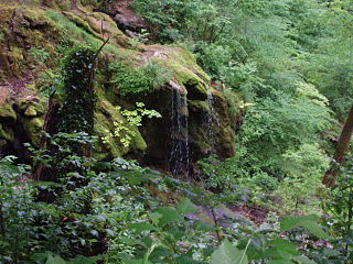
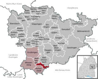
Wiesensteig is a town in the district of Göppingen in Baden-Württemberg in southern Germany. It is located on the river Fils, 16 km south of Göppingen.

<span class="mw-page-title-main">Adelmannsfelden</span> Municipality in Baden-Württemberg, Germany

Adelmannsfelden is a municipality in the German state of Baden-Württemberg, in Ostalbkreis district.

<span class="mw-page-title-main">Abtsgmünd</span> Municipality in Baden-Württemberg, Germany

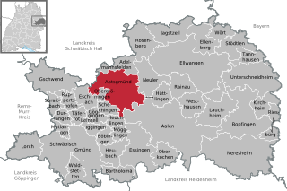
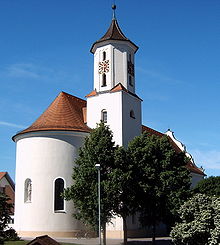
Abtsgmünd is a municipality in the German state of Baden-Württemberg, in Ostalbkreis district. Abtsgmünd is located at the confluence of two streams, the Lein and the Kocher. The large area municipality consists of the main town of Abtsgmünd as well as the five districts of Neubronn, Laubach, Untergröningen, Hohenstadt and Pommertsweiler and their associated villages and hamlets. The municipality is a state-recognized recreation area in the Swabian-Franconian Forest Nature Park.

<span class="mw-page-title-main">Gschwend, Baden-Württemberg</span> Municipality in Baden-Württemberg, Germany

Gschwend is a town in the German state of Baden-Württemberg, in Ostalbkreis district.

<span class="mw-page-title-main">Eschach, Germany</span> Municipality in Baden-Württemberg, Germany

Eschach is a municipality in the German state of Baden-Württemberg, in Ostalbkreis district.

<span class="mw-page-title-main">Bösingen, Baden-Württemberg</span> Municipality in Baden-Württemberg, Germany

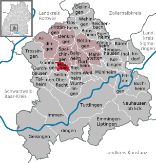
Bösingen is a municipality in the district of Rottweil, in Baden-Württemberg, Germany.

<span class="mw-page-title-main">Dietingen</span> Municipality in Baden-Württemberg, Germany

Dietingen is a municipality in the district of Rottweil, in Baden-Württemberg, Germany.

<span class="mw-page-title-main">Hochdorf, Esslingen</span> Municipality in Baden-Württemberg, Germany

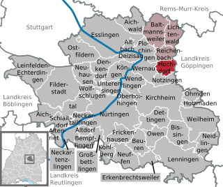
Hochdorf is a municipality in the district of Esslingen, Baden-Württemberg, in southern Germany. The mayors are Roland Erhardt and Gerhart Kuttler.

<span class="mw-page-title-main">Neidlingen</span> German municipality

Neidlingen is a municipality in the district of Esslingen, in Baden-Württemberg, Germany.

<span class="mw-page-title-main">Drackenstein</span> Municipality in Baden-Württemberg, Germany

Drackenstein is a municipality in the district of Göppingen in Baden-Württemberg in southern Germany.

<span class="mw-page-title-main">Eschenbach (Göppingen)</span> Municipality in Baden-Württemberg, Germany

Eschenbach is a municipality in the district of Göppingen in Baden-Württemberg in Germany.

<span class="mw-page-title-main">Hattenhofen, Baden-Württemberg</span> Municipality in Baden-Württemberg, Germany

Hattenhofen is a municipality in the district of Göppingen in Baden-Württemberg in southern Germany.

<span class="mw-page-title-main">Pfronstetten</span> Municipality in Baden-Württemberg, Germany

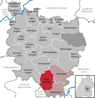
Pfronstetten is a town in the district of Reutlingen in Baden-Württemberg in Germany.

<span class="mw-page-title-main">Niedereschach</span> Municipality in Baden-Württemberg, Germany

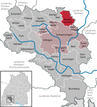
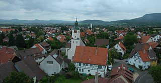
Niedereschach is a town, with 6000 inhabitants, in the district of Schwarzwald-Baar in Baden-Württemberg in Germany.

<span class="mw-page-title-main">Hausen ob Verena</span> Municipality in Baden-Württemberg, Germany

Hausen ob Verena is a municipality in the district of Tuttlingen in Baden-Württemberg in Germany.

<span class="mw-page-title-main">Reichenbach am Heuberg</span> Municipality in Baden-Württemberg, Germany

Reichenbach is a municipality in the district of Tuttlingen in Baden-Württemberg in Germany.

<span class="mw-page-title-main">Hüttlingen, Baden-Württemberg</span> Municipality in Baden-Württemberg, Germany

Hüttlingen is a municipality in the German state of Baden-Württemberg, in Ostalbkreis district.

<span class="mw-page-title-main">Dürnau, Göppingen</span> Municipality in Baden-Württemberg, Germany

Dürnau is a municipality in the district of Göppingen in Baden-Württemberg in southern Germany.

<span class="mw-page-title-main">Hertenstein Castle</span> Ruined castle in Baden-Württemberg, Germany

Hertenstein Castle is a ruined spur castle approximately 900 metres southwest of the village of Billingsbach, part of the municipality of Blaufelden, in the district of Schwäbisch Hall in the state of Baden-Württemberg, Germany.

References

  1. Aktuelle Wahlergebnisse, Staatsanzeiger, accessed 13 September 2021.
  2. "Bevölkerung nach Nationalität und Geschlecht am 31. Dezember 2022" [Population by nationality and sex as of December 31, 2022](CSV) (in German). Statistisches Landesamt Baden-Württemberg. June 2023.
  3. Naturräume Baden-Württembergs. Landesanstalt für Umwelt, Messungen und Naturschutz Baden-Württemberg, Stuttgart 2009.
  4. Das Land Baden-Württemberg. Amtliche Beschreibung nach Kreisen und Gemeinden. Band IV: Regierungsbezirk Stuttgart, Regionalverbände Franken und Ostwürttemberg. Kohlhammer, Stuttgart 1980, ISBN 3-17-005708-1, pages 711–713.
  5. http://neuler.de/gemeinde/geschichte.php Geschichte Neulers
  6. Statistisches Bundesamt (editor): Historisches Gemeindeverzeichnis für die Bundesrepublik Deutschland. Namens-, Grenz- und Schlüsselnummernänderungen bei Gemeinden, Kreisen und Regierungsbezirken vom 27.5.1970 bis 31.12.1982. W. Kohlhammer, Stuttgart / Mainz 1983, ISBN 3-17-003263-1, page 472.
  7. Volkszählungsergebnisse auf Leo-BW
  8. Hermann Sorg (2016-01-21). "Manfred Fischer ist seit 30 Jahren Bürgermeister". schwäbische (in German). Retrieved 2020-11-02.
  9. "Sabine Heidrich gewinnt Bürgermeisterwahl", Schwäbische, 2019-10-23, retrieved 2021-08-13