
The Southwestern United States, also known as the American Southwest or simply the Southwest, is a geographic and cultural region of the United States that includes Arizona and New Mexico, along with adjacent portions of California, Colorado, Nevada, Oklahoma, Texas, and Utah. The largest cities by metropolitan area are Phoenix, Las Vegas, El Paso, Albuquerque, and Tucson. Before 1848, in the historical region of Santa Fe de Nuevo México as well as parts of Alta California and Coahuila y Tejas, settlement was almost non-existent outside of Nuevo México's Pueblos and Spanish or Mexican municipalities. Much of the area had been a part of New Spain and Mexico until the United States acquired the area through the Treaty of Guadalupe Hidalgo in 1848 and the smaller Gadsden Purchase in 1854.

Heroica Nogales, more commonly known as Nogales, is a city and the county seat of the Municipality of Nogales in the Mexican state of Sonora. It is located in the north of the state across the U.S.-Mexico border, and is abutted on its north by the city of Nogales, Arizona.

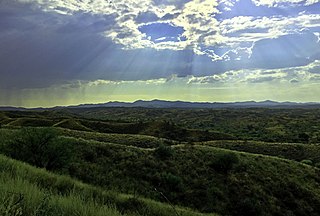
Skeleton Canyon, called Cañon Bonita by the Mexicans, is located 30 miles (50 km) northeast of the town of Douglas, Arizona, in the Peloncillo Mountains, which straddle the modern Arizona and New Mexico state line, in the New Mexico Bootheel region.

Aridoamerica is a cultural and ecological region spanning Northern Mexico and the Southwestern United States, defined by the presence of the drought-resistant, culturally significant staple food, the tepary bean. Its dry, arid climate and geography stand in contrast to the verdant Mesoamerica of present-day central Mexico into Central America to the south and east, and the higher, milder "island" of Oasisamerica to the north. Aridoamerica overlaps with both.
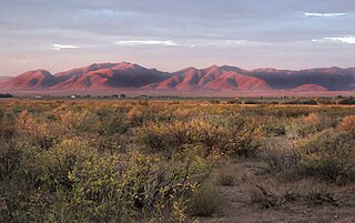
The Guadalupe Canyon Massacre was an incident that occurred on August 13, 1881, in the Guadalupe Canyon area of the southern Peloncillo Mountains – Guadalupe Mountains. Five American men were killed in an ambush, including "Old Man" Clanton, the alleged leader. They most likely belonged to The Cowboys, an outlaw group based in Pima and Cochise counties in Arizona. Two men survived the attack. The canyon straddles the modern Arizona and New Mexico state line and connects the Animas Valley of New Mexico with the San Bernardino Valley of Arizona. During the American Old West, the canyon was a key route for smugglers into and out of Mexico.

The broad-billed hummingbird is a small-sized hummingbird that resides in Mexico and the southwestern United States. Males and females have different features. The juveniles resemble the female adult more than the male adult. The broad-billed hummingbird is a bright coloured bird with a broad and bright red bill. The bird is also known for its other common names – the Colibrí Pico Ancho in Spanish and Colibri circé in French. It is more active during the day and less active during the night.

Estado de Occidente was a Mexican state established in 1824. The constitution was drafted in that year and the government was initially established with its capital at El Fuerte, Sinaloa. The first governor was Juan Miguel Riesgo. The state consisted of modern Sonora and Sinaloa, and also modern Arizona more or less south of the Gila River.
The Skeleton Canyon massacres refer to two separate attacks on Mexican citizens in 1879 and 1881. Skeleton Canyon is located in the Peloncillo Mountains, which straddles the modern Arizona and New Mexico state line border. This canyon connects the Animas Valley of New Mexico with the San Simon Valley of Arizona.

The San Pedro River is a northward-flowing stream originating about 10 miles (16 km) south of the international border south of Sierra Vista, Arizona, in Cananea Municipality, Sonora, Mexico. The river starts at the confluence of other streams just east of Sauceda, Cananea. Within Arizona, the river flows 140 miles (230 km) north through Cochise County, Pima County, Graham County, and Pinal County to its confluence with the Gila River, at Winkelman, Arizona. It is the last major undammed desert river in the American Southwest, and it is of major ecological importance as it hosts two-thirds of the avian diversity in the United States, including 100 species of breeding birds and almost 300 species of migrating birds.
The Southeastern Arizona Bird Observatory (SABO) is a nonprofit membership-supported scientific and educational organization founded in 1996 in Bisbee, Arizona, USA. The mission of the Southeastern Arizona Bird Observatory is to promote the conservation of the birds of southeastern Arizona, their habitats, and the diversity of species that share those habitats through research, monitoring, and public education. The observatory's founders are Tom Wood and Sheri Williamson, former managers of The Nature Conservancy's Ramsey Canyon Preserve.

The Huachuca Mountains are part of the Sierra Vista Ranger District of the Coronado National Forest in Cochise County in southeastern Arizona, approximately 70 miles (110 km) south-southeast of Tucson and southwest of the city of Sierra Vista. Included in this area is the highest peak in the Huachucas, Miller Peak, and the region of the Huachucas known as Canelo Hills in eastern Santa Cruz County. The mountains range in elevation from 3,934 feet (1,199 m) at the base to 9,466 feet (2,885 m) at the top of Miller Peak. The second highest peak in this range is Carr Peak, elevation 9,200 feet (2,804 m). The Huachuca Mountain area is managed principally by the United States Forest Service (41%) and the U.S. Army (20%), with much of the rest being private land (32%). Sierra Vista is the main population center.
The Agua Dulce Mountains are a mountain range in the north-central Sonoran Desert of southwestern Arizona. The range is located in the extreme southwestern portion of Pima County, Arizona, immediately north of the international boundary with Mexico and about 30 mi (48 km) southwest of Ajo, Arizona. The range has three main sections that total about 15 miles in length and about nine miles in width. The range is located entirely within the Cabeza Prieta National Wildlife Refuge. The highpoint of the range is 2,852 feet (869 m) above sea level and is located at 32°01'32"N, 113°08'44"W. The summit is unnamed, but is marked on U.S. Geological Survey (USGS) maps for the "Quitovaquita" benchmark that was placed on the summit in 1920. The original surveyed height was 2,850 feet above sea level, but recent datum adjustments calculate the summit to be two feet higher.

The San Bernardino National Wildlife Refuge is located on the U.S.-Mexico border in Cochise County, Arizona. Situated at 3,720 to 3,920 feet (1,130–1,190 m) elevation in the bottom of a wide valley, the refuge encompasses a portion of the headwaters of the Yaqui River, which drains primarily western Chihuahua and eastern Sonora, Mexico. The 2,309-acre (9.34 km2) ranch was acquired by the U.S. Fish and Wildlife Service in 1982 to protect the water resources and provide habitat for endangered native fishes.

Agua Prieta is a municipality in the state of Sonora in north-western Mexico. In 2015, the municipality had a total population of 82,918; by 2020, it had risen to 91,929.
The San Luis Mountains are a small, lower elevation mountain range of central-southern Pima County Arizona adjacent to the U.S.-Mexico border, northeast of Sasabe, Arizona–Sasabe, Sonora.
The Pajarito Mountains is a small mountain range of western Santa Cruz County, Arizona, United States, that extend south into Sonora, Mexico. The range is adjacent the Atascosa Mountains at its north, with both ranges in the center of a north-south sequence of ranges called the Tumacacori Highlands. The Highlands have the Tumacacori Mountains at the north, and south of the U.S.-Mexico border, the Sierra La Esmeralda range. The Tumacacori Highlands are part of a regional conservancy study of "travel corridors" for cats, called Cuatro Gatos, Four Cats, for mountain lions, ocelot, bobcat, and jaguar.
The Guadalupe Mountains of Hidalgo County are a 13 mi (21 km) long, sub-range in southwest Hidalgo County, New Mexico, United States, adjacent to the southeast border of Arizona's Cochise County. A small portion of the range is in Cochise County, namely the outlet of Guadalupe Canyon, famous for the Guadalupe Canyon Massacre. The southernmost end of the range is also in the border region of Sonora, just north of Federal Highway 2.
Stein's Pass, is a gap or mountain pass through the Peloncillo Mountains of Hidalgo County, New Mexico. The pass was named after United States Army Major Enoch Steen, who camped nearby in 1856, as he explored the recently acquired Gadsden Purchase. The pass is in the form of a canyon cut through the mountains through which Steins Creek flows to the west just west of the apex of the pass to the canyon mouth at 32°13′19″N109°01′48″W.
Whitewater Draw, originally Rio de Agua Prieta, [Spanish: river of dark water], is a tributary stream of the Rio de Agua Prieta in Cochise County, Arizona. It was called Blackwater Creek by Philip St. George Cooke when his command, the Mormon Battalion, camped at a spring on its course on December 5, 1846.

Pajarita Wilderness is a protected wilderness area managed by the Coronado National Forest in the U.S. state of Arizona. Established in 1984 under the Arizona Wilderness Act, the array of canyons that make up the area sit at the western end of the Pajarito Mountains, and form a well-known migration route for birds. Sycamore Canyon is the centerpiece of the wilderness, a riparian forest that supports more than 160 bird species.

