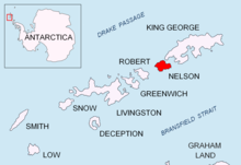
Livingston Island is an Antarctic island in the Southern Ocean, part of the South Shetlands Archipelago, a group of Antarctic islands north of the Antarctic Peninsula. It was the first land discovered south of 60° south latitude in 1819, a historic event that marked the end of a centuries-long pursuit of the mythical Terra Australis Incognita and the beginning of the exploration and utilization of real Antarctica. The name Livingston, although of unknown derivation, has been well established in international usage since the early 1820s.

Rugged Island is an island 3 miles (4.8 km) long and 1 mile (1.6 km) wide, lying west of Livingston Island in the South Shetland Islands. Its surface area is 10.4 square kilometres (4.0 sq mi). The island's summit San Stefano Peak rises to 256 metres (840 ft) above sea level. Rugged Island is located at 62°38′S61°15′W. Rugged Island was known to both American and British sealers as early as 1820, and the name has been well established in international usage for over 100 years.

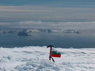
Simeon Peak rises to 1,580 m in Friesland Ridge, Tangra Mountains, Livingston Island in the South Shetland Islands, Antarctica. The peak is heavily glaciated, connected to St. Boris Peak to the northeast by Paril Saddle, and surmounts Huntress Glacier to the northwest, Ruen Icefall to the southwest, and Macy Glacier to the east. It was first ascended and GPS-surveyed by the Bulgarian climbers D. Boyanov, N. Petkov and N. Hazarbasanov from Nesebar Gap via the head of Huntress Glacier, Academia Peak, St. Boris Peak and Paril Saddle on 15 January 2017.

Varna Peninsula is a roughly rectangular predominantly ice-covered peninsula forming the northeast extremity of Livingston Island in the South Shetland Islands, Antarctica. It is bounded by Hero Bay to the northwest, by Moon Bay to the southeast, and by McFarlane Strait to the northeast.

Start Point is a point marking the northwest end of Byers Peninsula, Livingston Island in the South Shetland Islands, Antarctica and forming the southwest side of the entrance to Svishtov Cove and the northeast side of the entrance to the New Plymouth bay. Discovered by Edward Bransfield in January 1820, and so named by him because of its resemblance to a point on the south coast of England by the same name and because it was the place where his operations began.

Desolation Island is one of the minor islands in the South Shetlands archipelago, Antarctica situated at the entrance to Hero Bay, Livingston Island. The island is V-shaped with its northern coast indented by Kozma Cove. Surface area is 3.12 square kilometres (1.20 sq mi).

Cape Shirreff is a prominent cape at the north end of the rocky peninsula which separates Hero Bay and Barclay Bay on the north coast of Livingston Island, in the South Shetland Islands of Antarctica. The cape was named by Edward Bransfield in 1820 after Captain William H. Shirreff, the British commanding officer in the Pacific at that time.

Williams Point is the point forming both the north extremity of Varna Peninsula and the northeast tip of Livingston Island in the South Shetland Islands, Antarctica. Separated from Zed Islands to the north by Iglika Passage.

Hurd Peninsula lies between South Bay and False Bay on the south coast of Livingston Island in the South Shetland Islands, Antarctica. The Spanish Juan Carlos I Antarctic Base and the Bulgarian St. Kliment Ohridski Base are situated on its west coast.

New Plymouth is a bay bordered by an extensive line of beaches, lying south of Start Point and between Rugged Island and the west end of Livingston Island in the South Shetland Islands, Antarctica.

Johnsons Dock is a sheltered 500 m wide cove indenting for 900 m the northwest coast of Hurd Peninsula on Livingston Island in the South Shetland Islands, Antarctica. It is part of South Bay entered north of Ballester Point. Surmounted by Charrúa Ridge on the northeast. The cove was frequented by early 19th century sealers.

Essex Point is a point at the northwest end of Byers Peninsula, Livingston Island in the South Shetland Islands, Antarctica. It forms the west side of the entrance to Barclay Bay and the northeast side of the entrance to Svishtov Cove, and is surmounted by Drong Hill.

Window Island is a small ice-free island off the north coast of Ray Promontory in the northwest of Byers Peninsula, Livingston Island in the South Shetland Islands, Antarctica. The island has a surface area of 23 hectares and rises to 72 m (236 ft). It was known to the early 19th century sealers operating on Byers Peninsula.

Ivanov Beach is a mostly ice-free beach on the Drake Passage stretching 5 km (3.1 mi) in southwest–northeast direction on the southeast coast of Barclay Bay in western Livingston Island, South Shetland Islands in Antarctica. It extends to Nedelya Point and Byers Peninsula on the southwest, Rowe Point and Etar Snowfield on the northeast, and the slopes of Rotch Dome on the southeast. Its ice-free area is ca. 144 hectares.

Vidaurre Point is the ice-free south extremity of Nelson Island in the South Shetland Islands, Antarctica, also the west entrance point of Bononia Cove and east entrance point of Dorticum Cove on the south coast of the island. The area was visited by early 19th century sealers. The feature was named by Chile.

Dorticum Cove is the 2.2 km wide cove indenting for 720 m the south coast of Nelson Island in the South Shetland Islands, Antarctica. It is entered west of Vidaurre Point, the south extremity of the island. The area was visited by early 19th century sealers.

Baba Marta Beach is the ice-free beach on the south coast of Nelson Island in the South Shetland Islands, Antarctica, extending 1.8 km eastwards from Ross Point. Its surface area is 43 ha. The area was visited by early 19th century sealers.

Long Beach is the ice-free beach on the southwest coast of Nelson Island in the South Shetland Islands, Antarctica, extending 1 km northwards from Ross Point. Its surface area is 24.7 ha. The area was visited by early 19th century sealers.

Malak Sechko Cove is the 1.8 km wide cove indenting for 760 m the northwest coast of Guangzhou Peninsula on Nelson Island in the South Shetland Islands, Antarctica north of Harmony Point. The area was visited by early 19th century sealers.

Frisius Point is the rocky north entrance point of Malak Sechko Cove and southwest entrance point of Golyam Sechko Cove projecting 450 m westwards from the northwest coast of Guangzhou Peninsula on Nelson Island in the South Shetland Islands, Antarctica. The area was visited by early 19th century sealers. Frisius Point is part of both Antarctic Specially Protected Area Harmony Point and the BirdLife International Important Bird Area Harmony Point, Nelson Island.


