
Papua New Guinea has 326 local-level governments (LLGs) comprising 6,112 wards as of 2018.
Star Mountains Rural LLG is a local-level government situated in the Star Mountains in North Fly District of Western Province of Papua New Guinea. In the year 2000, the LLG had 1691 homes, and a population of 12,114 people. The current population is more likely to now be around 15,000 people. The main population centre in the LLG is Tabubil. Finalbin and the Ok Tedi Mine are also in this LLG.

Olsobip Rural LLG is a local-level government situated in North Fly District of Western Province of Papua New Guinea. In the year 2000, the LLG was the least populous of the district, with a population of only 3851 people. The capital of the LLG is a station town by the name of Olsobip.
Ningerum Rural LLG is a local-level government area situated in North Fly District of Western Province of Papua New Guinea. In the year 2000, the LLG had a population of 13,156 people. The main population centre is Ningerum.
Kiunga Rural LLG is a local-level government area situated in North Fly District of Western Province of Papua New Guinea. In the year 2000, the LLG had a population of 13,249 people. The township of Kiunga is within the boundaries of this LLG, but has its own urban LLG.
Kiunga Urban LLG is a local-level government area situated in North Fly District of Western Province of Papua New Guinea. In the year 2000, the LLG had a population of 8265 people. The township of Kiunga, which is governed by this LLG is the government seat of the district.
The Kavieng Urban LLG is a local government area in New Ireland Province, Papua New Guinea. The LLG is located in Kavieng District and the LLG headquarters is Kavieng. This LLG has six wards. The population is 16,725 and the Lord Mayor is Hon. Stanley Mansini MPA.
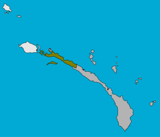
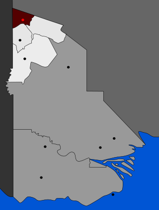
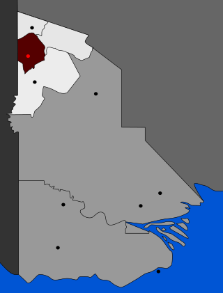
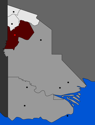
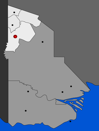
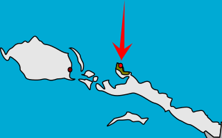
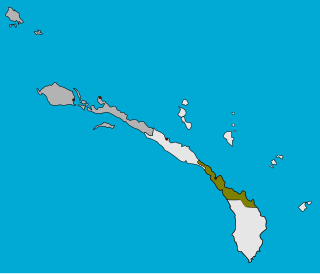
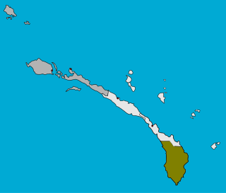
Tikana Rural LLG is a local government area in New Ireland Province, Papua New Guinea. The LLG administers the northern section of the island of New Ireland, as well as Djaul Island and some Tigak islands in the strait between New Ireland and New Hanover.

Lovongai Rural LLG is a local government area in New Ireland Province, Papua New Guinea. The LLG administers the island of New Hanover and a few surrounding islands. The LLG is located in Kavieng District and the LLG headquarters is Taskul. Some population centres in the LLG are: Taskul, Patiagaga, Patipai, Ungakum, Tsoi, Tukulisava, and Ungalik. This LLG has 19 wards, comprising a population of 29,005. Current LLG President is John Aini.

Murat Rural LLG is a local government area in New Ireland Province, Papua New Guinea. The LLG president is Herman Sole. The LLG administers the St. Matthias Group of islands and is located in Kavieng District. Population is 4,210(Census 2011).
Namatanai Rural LLG is a local government area in New Ireland Province, Papua New Guinea. The LLG is located in Namatanai District and the LLG headquarters is Namatanai.
Konoagil Rural LLG is a local government area in New Ireland Province, Papua New Guinea. The LLG administers the southern peninsula of the island of New Ireland. The LLG is located in Namatanai District and its population is 10,503. Languages in the area are Siar-Lak language, Kandas language, and Label language.

Nimamar Rural LLG is a local government area in New Ireland Province, Papua New Guinea. The LLG administers the Lihir Group of islands. The LLG is located in Namatanai District and contains the Lihir Gold Mine, which is the second largest gold deposit in the world. Main language spoken here is the Lihir language. Many speakers of other languages are present here due to the mining on the island. Commonly are Niwer Mil language, Kuanua language and Mandara language.
This page is a list of districts of Papua New Guinea.
For administrative purposes, Papua New Guinea (PNG) is divided into administrative divisions called regions and provinces. Papua New Guinea is divided into four regions and 22 province-level divisions: 20 provinces plus the autonomous region (Bougainville) and the National Capital District.
The Tapini Rural LLG is a local-level government area situated in the Goilala District of the Central Province of Papua New Guinea. In 2000, the LLG had 1,685 households, and a population of 7,315. The LLG has a President and a Deputy President, and elections are normally held every five years after the national elections in September.
The Kairuku Rural LLG is a local level government area situated in the Kairuku-Hiri District of the Central Province of Papua New Guinea. In 2000, the LLG had 3,485 households, and a population of 19,503. As of 2007, 3,078 students are enrolled in 20 schools in the LLG. The area is divided into 17 wards, and spreads along the coast on either side of the Hiritano Highway leading north-west from the national capital, Port Moresby.
The Louisiade Rural LLG is a local level government in the Milne Bay Province of Papua New Guinea. The LLG is situated in the Louisiade Archipelago. At the 2011 census, it contained 23,335 residents living in 4,542 households. The LLG president is Benjamin Kuli. It launched its own microfinance scheme in December 2016.
Aitape West Rural LLG is a local-level government (LLG) of Aitape in Sandaun Province, Papua New Guinea.
Woitape Rural LLG is a local-level government (LLG) of Central Province, Papua New Guinea.
