
Chimbu, more frequently spelled Simbu, is a province in the Highlands Region of Papua New Guinea. The province has an area of 6,112 km2 and a population of 376,473. The capital of the province is Kundiawa. Mount Wilhelm, the tallest mountain in Papua New Guinea is on the border of Eastern part of Simbu and the Western part of Madang Province.
Oro Province, formerly Northern Province, is a coastal province in the Southern Region of Papua New Guinea. The provincial capital is Popondetta. The province covers 22,800 km2, and has 176,206 inhabitants. The province shares land borders with Morobe Province to the northwest, Central Province to the west and south, and Milne Bay Province to the southeast. The province is located within the Papuan Peninsula.

East Sepik is a province in Papua New Guinea. Its capital is Wewak. East Sepik has an estimated population of 433,481 people and is 43,426 km square in size.

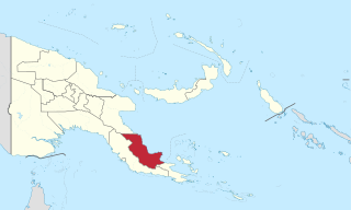
Central Province is a province in Papua New Guinea located on the southern coast of the country. It has a population of 237,016 people and is 29,998 square kilometres (11,582 sq mi) in size. The seat of government of Central Province, which is located within the National Capital District outside the province, is the Port Moresby suburb of Konedobu. On 9 October 2007, the Central Province government announced plans to build a new provincial capital city at Bautama, which lies within Central Province near Port Moresby, although there has been little progress in constructing it.

Manus Province is the smallest province in Papua New Guinea in terms of both land area and population, with a land area of 2,100 square kilometres (810 sq mi), but with more than 220,000 square kilometres (85,000 sq mi) of water, and the total population is 60,485. The provincial town of Manus is Lorengau.

Namatanai District is the southernmost and larger of the two districts of New Ireland Province in Papua New Guinea. The district covers the southern part of the island of New Ireland, as well as the Tabar Group, the Lihir Group, the Tanga Islands and the Feni Islands.
Jimi District is a district of the Jiwaka Province of Papua New Guinea. Its capital is Tabibuga. The population of the district was 71,379 at the 2011 census. Before May 2012, it was part of the Western Highlands Province. It is home to the Jimi Valley and the village of Koinambe.

Pawaia, also known as Sira, Tudahwe, Yasa, is a Papuan language that forms a tentative independent branch of the Trans–New Guinea family in the classification of Malcolm Ross (2005).
Bogaya (Pogaya) is a Papuan language of Papua New Guinea. In Western Province, Bogaya is spoken in Olsobip Rural LLG and Nomad Rural LLG. It is also spoken in Koroba-Kopiago District, Hela Province.
The Tapini Rural LLG is a local-level government area situated in the Goilala District of the Central Province of Papua New Guinea. In 2000, the LLG had 1,685 households, and a population of 7,315. The LLG has a President and a Deputy President, and elections are normally held every five years after the national elections in September.
Foia Foia (Foyafoya), or Minanibai, is a Papuan language of Papua New Guinea, spoken in an area near Omati River mouth in Ikobi Kairi and Goaribari Census districts.
Gorovu is a nearly extinct Ramu language of Papua New Guinea.
Ronji is a minor Austronesian language of northern Papua New Guinea.
Woitape Airport is an airfield serving Woitape, in the Central Province of Papua New Guinea.
Tapini Airport is an airfield serving Tapini, in the Central Province of Papua New Guinea.

Jiwaka is a province of Papua New Guinea. The government gazetted provincial capital is located in Kurumul. Temporarily all provincial matters are handled in Minj after the election of the new Governor in 2022 general elections. Matters concerning each district are dealt with at their respective district administration office.
Zania is a village in the Tapini Rural LLG of Goilala District of Papua New Guinea.
Robert Agarobe is a Papua New Guinea businessman and politician. He was the Governor of Central Province and a Member of the National Parliament of Papua New Guinea, but was unseated by Rufina Peter in the 2022 Papua New Guinean general election.
Woitape Rural LLG is a local-level government (LLG) of Central Province, Papua New Guinea.
Rufina Peter is a Papua New Guinean agricultural economist and politician. Until her election to the National Parliament on 5 August 2022, Papua New Guinea (PNG) was one of only three countries without a woman in parliament. She was also elected as Governor of Central Province in the 2022 general election, becoming the province's first female governor.
