Slovenia is situated at the crossroads of central and southeast Europe, touching the Alps and bordering the Adriatic Sea. The Alps—including the Julian Alps, the Kamnik–Savinja Alps and the Karawank chain, as well as the Pohorje massif—dominate northern Slovenia along its long border to Austria. Slovenia's Adriatic coastline stretches approximately 47 km (29 mi) from Italy to Croatia. Its part south of Sava river belongs to Balkan peninsula – Balkans.

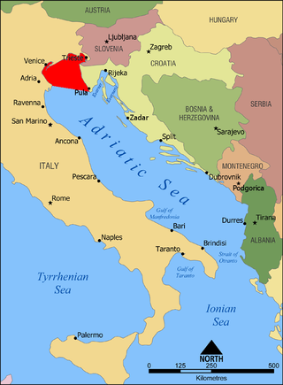
Istria is the largest peninsula within the Adriatic Sea. Located at the top of the Adriatic between the Gulf of Trieste and the Kvarner Gulf, the peninsula is shared by three countries: Croatia, Slovenia, and Italy, 90% of its area being part of Croatia. Most of Croatian Istria is part of Istria County.

Istria County is the westernmost county of Croatia which includes the majority of the Istrian peninsula.

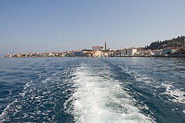
Piran is a town in southwestern Slovenia on the Gulf of Piran on the Adriatic Sea. It is one of the three major towns of Slovenian Istria. The town is known for its medieval architecture, with narrow streets and compact houses. Piran is the administrative seat of the Municipality of Piran and one of Slovenia's major tourist attractions.

The Gulf of Trieste is a shallow bay of the Adriatic Sea, in the extreme northern part of the Adriatic Sea. It is part of the Gulf of Venice and is shared by Italy, Slovenia and Croatia. It is closed to the south by the peninsula of Istria, the largest peninsula in the Adriatic Sea, shared between Croatia and Slovenia. The entire Slovenian sea is part of the Gulf of Trieste.
The Gulf of Venice is an informally recognized gulf of the Adriatic Sea. It lies at the extreme north end of the Adriatic, limited on the southwest by the easternmost point of the Po Delta in Italy and on the southeast by the southernmost point of the Istrian Peninsula in Croatia. It is bordered by the coastlines of northeastern Italy and southwestern Croatia and Slovenia.

The A9 motorway is a north–south motorway in Croatia, with a length of 78.3 kilometres. Beginning in Pula, the largest city on the Istrian peninsula, it runs north to the Croatian motorway and expressway network at the Kanfanar interchange. Here it meets the A8 motorway, forming the Istrian Y road system. The A9 continues north from here to the Kaštel and Plovanija border crossings into Slovenia. The motorway represents a significant north–south transportation corridor in Croatia and is a part of the European route E751. The motorway's national significance is reflected in the positive economic impact on the cities and towns it connects, as well as its importance to tourism in Croatia. Importance of the motorway for tourism is particularly high during summer tourist seasons, when traffic volume increases by more than 80%.
The Italian language is an officially recognized minority language in Slovenia, along with Hungarian. Around 3,700 Slovenian citizens speak Italian as their mother tongue, mostly Istrian Italians. Their numbers drastically decreased following the Istrian–Dalmatian exodus (1943–1960). Italian has a strong presence in Slovenia, both historical and current. An estimated 15% of Slovenians speak Italian as a second language, which is one of the highest percentages in the European Union.

The European route E751, or E751, as defined by the Declaration on the Construction of Main International Traffic Arteries of 1975, and subsequent documents which amended the treaty, is an east–west Class-B branching European road route. Originating in Rijeka, Croatia, where it diverges from European route E61 before passing through the Kanfanar interchange, the route connects Pula, Rovinj, Poreč and Umag in Croatia with Koper in Slovenia. The route provides a high-performance road link in Istria and Slovenian Littoral. Unlike most routes, the E751 centers on the Kanfanar interchange and has three arms, each extending to Rijeka, Pula and Koper. The total length of the route, including all the route arms, is 160 km (99 mi).

The Dragonja is a 30-kilometre (19 mi) long river in the northern part of the Istrian peninsula. It is a meandering river with a very branched basin and a small quantity of water. It has a pluvial regime and often dries up in summer. It features very diverse living environments and is home to a number of animal and plant species. The Dragonja has been a matter of a territorial dispute between Croatia and Slovenia, with its lowest portion de facto the border of the two countries.
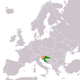
The foreign relations between Croatia and Slovenia are bound together by shared history, neighboring geography and common political ideologies. Both states established diplomatic relations in 1992, following the dissolution of Yugoslavia and the independence of Croatia. Modern relations are warm and friendly. The two states have disputes over their border and sovereign rights over certain nuclear and economic assets. The countries share 670 km (420 mi) of common border. They are perennially each other's largest trading partners on an import-export basis.

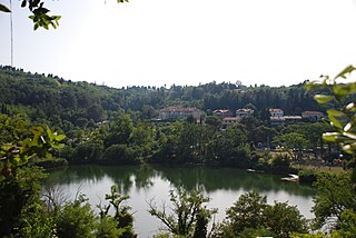
Dragonja is a settlement in the Municipality of Piran in the Littoral region of Slovenia.

The Adriatic Sea is a body of water separating the Italian Peninsula from the Balkan Peninsula. The Adriatic is the northernmost arm of the Mediterranean Sea, extending from the Strait of Otranto to the northwest and the Po Valley. The countries with coasts on the Adriatic are Albania, Bosnia and Herzegovina, Croatia, Italy, Montenegro, and Slovenia.
Following the breakup of Yugoslavia in 1991, Slovenia and Croatia became independent countries. As the border between the countries had not been determined in detail prior to independence, several parts of the border were disputed, both on land and at the sea, namely in the Gulf of Piran.
Fiesa is a street in Portorož, a settlement in the Municipality of Piran. It mainly lies in a small plain next to Fiesa Bay west of Strunjan and southeast of Piran. The beachfront west and east of the central part has high cliffs. It is connected with Piran by a road through the hills and a beach promenade along the northern beachfront. There are two hotels, a few guesthouses, and a camping site in Fiesa.

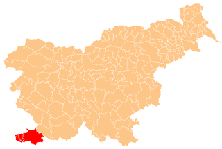
Slovene Istria is a region in southwest Slovenia. It comprises the northern part of the Istrian peninsula, and is part of the wider geographical-historical region known as the Slovene Littoral. Its largest urban center is Koper. Other large settlements are Izola, Piran, and Portorož. The entire region has around 120 settlements. In its coastal area, both Slovene and Italian are official languages.

The Sečovlje Saltworks is the largest Slovenian salt evaporation pond. Along with the Strunjan Saltworks, they are the northernmost Mediterranean saltworks and one of the few where salt is still produced in a traditional way, as well as a wetland of international importance and a breeding place for waterbirds. They are part of the Piran Saltworks and are located at Parecag in Slovenian Istria, the southwest of the country, at the Adriatic Sea, along the mouth of the Dragonja River near Sečovlje.

The Slovene Riviera is the coastline of Slovenia, located on the Gulf of Trieste, by the Adriatic Sea. It is part of the Istrian peninsula and is 46.6 km long. The region comprises the towns of Koper and Piran with Portorož, and the municipality of Izola. It is a seaside tourist destination, with a vibrant multiethnic Slovenian and Italian heritage.

The Gulf of Koper or Koper Bay is located in the northern part of the Adriatic Sea, and is a part of the Gulf of Trieste.

The Municipality of Piran is a municipality in the traditional region of the Littoral in southwestern Slovenia. The seat of the municipality is the town of Piran. Piran became a municipality in 1994.