Gundabooka, Yanda

Last updated

Gundabooka Parish
New South Wales
Australia New South Wales location map blank.svg
Red pog.svg
Gundabooka Parish
Coordinates 30°32′0″S145°47′0″E / 30.53333°S 145.78333°E / -30.53333; 145.78333 Coordinates: 30°32′0″S145°47′0″E / 30.53333°S 145.78333°E / -30.53333; 145.78333
Postcode(s) 2840
Elevation100 m (328 ft)
LGA(s) Bourke Shire
State electorate(s) Barwon
Federal division(s) Parkes

Gundabooka Parish is a civil parish, [1] of Yanda County, a cadasteral division of New South Wales; [2] a Cadastral division of New South Wales. [3] [4] [5] [6]

Contents

Location

The Parish is on the Darling River upstream of Louth, New South Wales [7] [8] and down stream of Bourke, New South Wales and is located at 30°48′57″S 145°48′36″E.

Geography

The topography is flat with a Köppen climate classification of BsK (Hot semi arid). [9] The climate is characterised by hot summers and mild winters. The annual average rainfall is 350 mm, although this is highly variable. [10]

Much of the Parish is in the Gundabooka National Park and adjoining conservation area. [11] [12]

Etymology

Gunderbooka is believed to be derived from a local Aboriginal word and is also the name of Gundabook Station. [13]

History

The traditional owners of the area are the Ngamba and Barkindji peoples [14] [15]
The first European to the area was Thomas Mitchell (explorer).

See also

Related Research Articles

<span class="mw-page-title-main">Gundabooka National Park</span> Protected area in New South Wales, Australia

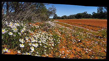
The Gundabooka National Park is a protected national park in the north-west region of New South Wales, in eastern Australia. The 63,902-hectare (157,910-acre) national park is located approximately 820 kilometres (510 mi) northwest of Sydney. The nearest town is Bourke, 70 kilometres (43 mi) to the north.

Cobar was an electoral district of the Legislative Assembly in the Australian state of New South Wales which was named after the town of Cobar. It was first created in 1894 and abolished in 1920. Cobar was recreated in 1930 and abolished in 1968.

<span class="mw-page-title-main">Irrara County</span> Cadastral in New South Wales, Australia

Irrara County is one of the 141 Cadastral divisions of New South Wales. It is located south of the border with Queensland, east of the Paroo River, and west of the Warrego River.

<span class="mw-page-title-main">Mouramba County</span> Cadastral in New South Wales, Australia

Mouramba County is one of the 141 Cadastral divisions of New South Wales.

<span class="mw-page-title-main">Parish of Tarago</span> Cadastral in New South Wales, Australia

The Parish of Tarago is a parish of Argyle County. It does not actually contain the town of Tarago, which is located further to the south-east in the Parish of Mulwaree. The Parish was built by the Department of Lands in New South Wales.

<span class="mw-page-title-main">Parish of Donalroe</span>

Donalroe Parish in Cobar Shire is a civil parish of Rankin County,; a Cadastral division of New South Wales.

<span class="mw-page-title-main">Parish of Budda</span>

Budda Parish in Cobar Shire is a civil parish of Rankin County,; a Cadastral division of New South Wales.

<span class="mw-page-title-main">Parish of Tankarook</span>

Tankarrok Parish in Cobar Shire is a civil parish of Rankin County,; a Cadastral division of New South Wales.

<span class="mw-page-title-main">Parish of Buckinbe</span>

Buckinbe Parish in Cobar Shire is a civil parish of Rankin County,; a Cadastral division of New South Wales.

<span class="mw-page-title-main">Parish of Wallandra</span> Civil parish in New South Wales, Australia

Wallandra Parish in Cobar Shire is a civil parish of Rankin County, a Cadastral division of New South Wales. The Parish is on the Darling River upstream of Wilcannia, New South Wales and is located at 30.5511°N 144.3351°E. The only town of the parish is Tilpa, New South Wales.

Cumbedore Parish, Yanda County in Bourke Shire is a civil parish of Yanda County, a cadasteral division of New South Wales; a Cadastral division of New South Wales.

Canpadore Parish, Yanda County in Bourke Shire is a civil parish of Yanda County, a cadasteral division of New South Wales; a Cadastral division of New South Wales.

Dootheboy, in Cobar Shire is a civil parish of Yanda County a Cadastral division of New South Wales.

Bright Parish, in Cobar Shire is a civil parish of Yanda County a Cadastral division of New South Wales.

Kenindee Parish, in Cobar Shire is a civil parish of Yanda County a Cadastral division of New South Wales.

Kenindee Parish, in Cobar Shire is a civil parish of Yanda County a Cadastral division of New South Wales.

Emu Parish, in Cobar Shire is a civil parish of Yanda County a Cadastral division of New South Wales.

<span class="mw-page-title-main">Dunlop Parish (Yanda County)</span> Place in New South Wales, Australia

Dunlop Parish is a civil parish, of Yanda County, a cadasteral division of New South Wales; a Cadastral division of New South Wales.

Yanda Parish, is a civil parish, of Yanda County, a cadasteral division of New South Wales; a Cadastral division of New South Wales.

Loftus Parish is a civil parish of Cowper County, New South Wales; a Cadastral division of New South Wales. located at 30°13'05.0"S 146°27'57.0"E between Byrock, New South Wales and Bourke, New South Wales.

References

  1. Map of the County of Yanda, Western Division, NSW 1918.
  2. [cartographer] C.A. Orwin, [https://nla.gov.au/nla.obj-233873384/view Map of the County of Rankin : Western Division, Land Districts of Bourke, Cobar and Wilcannia, N.S.W. 1912 (New South Wales. Department of Lands Title, Sydney N.S.W. 1914).
  3. "Rankin". Geographical Names Register (GNR) of NSW. Geographical Names Board of New South Wales . Retrieved 4 August 2013. OOjs UI icon edit-ltr-progressive.svg
  4. The New atlas of Australia (John Sands, 1886) map 24.
  5. Yanda County Archived 6 May 2018 at the Wayback Machine , GEOGRAPHICAL NAMES REGISTER EXTRACT.
  6. / The New atlas of Australia, (John Sands, 1886), map 24.
  7. [cartographer] C.A. Orwin, [https://nla.gov.au/nla.obj-233873384/view Map of the County of Rankin : Western Division, Land Districts of Bourke, Cobar and Wilcannia, N.S.W. 1912 (New South Wales. Department of Lands Title, Sydney N.S.W. 1914).
  8. The New atlas of Australia (John Sands, 1886) map 24.
  9. Peel, M. C.; Finlayson, B. L.; McMahon, T. A. (2007). "Updated world map of the Köppen–Geiger climate classification". Hydrol. Earth Syst. Sci. 11: 1633–1644. doi: 10.5194/hess-11-1633-2007 . ISSN   1027-5606.(direct: Final Revised Paper)
  10. Gundabooka National Park Plan of Management page 2.
  11. Gundabooka National Park at NSW National Parks.
  12. Gundabooka-national-park at visit NSW.
  13. "Gunderbooka". Geographical Names Register (GNR) of NSW. Geographical Names Board of New South Wales . Retrieved 6 January 2012. OOjs UI icon edit-ltr-progressive.svg
  14. Norman Tindale's Catalogue of Australian Aboriginal Tribes
  15. Aboriginal Australia Map, David Horton (ed.), 1994 published in The Encyclopedia of Aboriginal Australia by AIATSIS.