
Gungahlin is a district in the Australian Capital Territory, one of fastest growing regions in Australia. The district is subdivided into suburbs, sections and blocks. Gungahlin is an Aboriginal word meaning either "white man's house" or "little rocky hill".

Meadowhall Interchange is a transport interchange located in north-east Sheffield, consisting of a combined heavy rail station, tram stop and bus and coach station. The second-busiest heavy rail station in the city in terms of passenger numbers, Meadowhall Interchange provides connections between National Rail services, the Sheffield Supertram light rail network, intercity coach services and the city bus network.
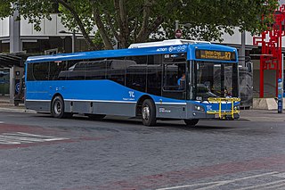
ACTION is a bus operator in Canberra, Australia, and is owned by the Government of the Australian Capital Territory.

Bradford Interchange is a transport interchange in Bradford, West Yorkshire, England, which consists of a railway station and bus station adjacent. The Interchange, which was designed in 1962, was hailed as a showpiece of European design and was opened on 14 January 1973. It is served by the majority of bus services in the city centre, while the railway station, which is one of two in the city centre, is served by Northern and is also the terminus for Grand Central services from London King's Cross.
A through service is a concept of passenger transport that involves a vehicle travelling between lines, networks or operators on a regularly specified schedule, on which the passenger can remain on board without alighting. It may be in form of either the following:

Metrobus is a high frequency, high capacity bus network in Sydney, Australia, first introduced in 2008. Metrobus services run every 10 minutes during peak periods, 15 minutes during off-peak weekday periods, and 20 minutes on weekends, linking key commercial suburbs and centres throughout the city, with the intention of making timetables obsolete. All buses were initially painted in a distinctive red livery but recently, the standard Transport for NSW livery of blue and white has been adopted. All Metrobus services are wheelchair accessible. All route numbers were prefixed with an "M" followed by a two-digit number.

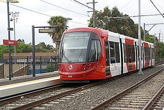
The Canberra light rail network, also known as Canberra Metro, is a light rail system serving the city of Canberra, Australia. The initial 12-kilometre (7.5 mi) line links the northern town centre of Gungahlin to the city centre (Civic) and has 14 stops. Services commenced on 20 April 2019. The 14th stop at Sandford Street in Mitchell commenced operation in September 2021.
The Inner West Light Rail is a 12.8-kilometre (8.0 mi) light rail line in Sydney, New South Wales, Australia, running from Central railway station through the Inner West to Dulwich Hill and serving 23 stops. It was the original line of the Sydney light rail network. Services on the line are branded as the L1 Dulwich Hill Line since 2014.

Route R4 is a main cross-city bus route in Canberra, Australia operated by ACTION between Belconnen, City, Woden Town Centre and Tuggeranong.

Dickson Interchange is a transport interchange in Dickson, an inner-northern suburb of Canberra. The interchange allows transfers between the Canberra Metro light rail network and local ACTION bus services. As part of the construction of the Civic to Gungahlin light rail line, a new $4 million bus interchange opened in 2018. The interchange was built on land compulsorily acquired by the ACT Government in 2015, the terms of which were not disclosed to the public. Construction allowed direct access for bus and pedestrian traffic between Northbourne Avenue and Challis Street, as well as accommodation for up to nine local bus routes, a new taxi rank, kiss and ride facilities and signalised pedestrian crossings. The new facilities became an important connection point for commuters under a redesigned timetable that integrated bus and light rail services in early 2019.

EPIC and Racecourse is a light rail station on the Canberra Metro R1 Civic to Gungahlin line. Although technically located in the suburb of Lyneham, the station primarily serves Exhibition Park in Canberra (EPIC) - home to major annual events including Summernats, the National Folk Festival and Royal Canberra Show as well as Thoroughbred Park, the city's main venue for horse racing. The station is generally quiet outside of major events at these venues, serving the least passengers of any station on the line in the first 10 months of operation. Prior to the opening of the line, a park and ride facility was in use for ACTION bus commuters, this was temporarily relocated in 2016, but reopened in 2019 once construction was completed. In addition to the park and ride facilities, the station also provides bicycle racks. EPIC and Racecourse is unique on the line as it is the only station that is not constructed within the centre median of a major road.

Well Station Drive is a light rail station on the Canberra Metro R1 Civic to Gungahlin line, located at the intersection of Well Station Drive and Flemington Road. It serves the residential suburb of Harrison, the Shirley Smith High School in Kenny and is the closest station to many businesses in Mitchell. The station's location and lack of suitable footpaths makes access to the industrial area difficult for pedestrians, leading to safety concerns within the community. Bicycle racks and "kiss and ride" bays are currently installed around the intersection adjacent to the station.

Nullarbor Avenue is a light rail station on the Canberra Metro R1 Civic to Gungahlin line, located at the intersection of Nullarbor Avenue and Flemington Road. The station was a key location during construction and testing of the light rail route and serves the suburbs of Franklin and Harrison. A crossover track is located immediately north of the platforms, making it possible for light rail vehicles to terminate here, however currently all services continue through the station. The station offers bicycle lockers in addition to "kiss and ride" bays, installed around the intersection adjacent to the station.

Mapleton Avenue is a light rail station in Australia on the Canberra Metro R1 Civic to Gungahlin line, located at the intersection of Mapleton Avenue, Flemington Road and Manning Clark Crescent. The station serves the suburbs of Franklin and Harrison and provides bicycle racks for commuters in addition to "kiss and ride" bays, installed around the intersection adjacent to the station.

Manning Clark North is a light rail station in Australia on the Canberra Metro R1 Civic to Gungahlin line, located at the intersection of Flemington Road and the western end of Manning Clark Crescent. The station serves the eastern part of the Gungahlin Town Centre as well as the adjacent suburbs of Franklin and Harrison. At the time of opening, much of the land surrounding the station was undeveloped. Bicycle racks and "kiss and ride" bay are provided on Flemington Road close to the station. At the time of opening, much of the land surrounding the station was undeveloped.

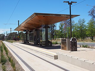
Sandford Street is a light rail station in Australia on the Canberra Metro R1 Civic to Gungahlin line, located at the intersection of Flemington Road, Sandford Street and Morriset Road in Mitchell. The station serves the surrounding business and industrial precinct, and will support future residential development in the neighbouring suburb of Kenny. Bicycle racks are provided around the intersection adjacent to the station. It is the only station on the Civic to Gungahlin route that did not open with stage 1 of the network.
Phillip Avenue is a light rail station in Australia on the Canberra Metro R1 Civic to Gungahlin line, located on the Federal Highway at the intersection of Phillip Avenue. The station primarily serves the suburb of Watson although it is close to Exhibition Park in Canberra and a few businesses in the northern part of Lyneham, providing an alternative to the EPIC and Racecourse station during major events. Bicycle racks are provided for commuters adjacent to the station, but there is no dedicated parking or "kiss and ride" bays available.

Swinden Street is a light rail station in Australia on the Canberra Metro R1 Civic to Gungahlin line, located on Northbourne Avenue at the intersection of Swinden Street, opposite the Lyneham sports complex. The station serves the suburbs of Lyneham and Downer, with a small dedicated park and ride that opened in December 2020. Bicycle racks are also provided for commuters adjacent to the station.

Elouera Street is a light rail station in Australia on the Canberra Metro R1 Civic to Gungahlin line, located at the intersection of Northbourne Avenue, Elouera Street and Gould Street. It is one of two stations serving the suburbs of Turner and Braddon. Bicycle racks are provided for commuters adjacent to the station. The station is close to Lonsdale Street, a popular dining and nightlife strip. Many businesses in this area were heavily impacted by road closures and delays during the construction phase, with a number of public car parks being lost to make way for light rail infrastructure contributing to prolonged accessibility issues.

Alinga Street light rail station is the terminus of the Canberra Metro R1 light rail line. It opened on 20 April 2019. As the main connection point for bus services to Canberra's southern districts as well as to Queanbeyan and Yass, Alinga Street is by far the busiest station on the route, with 37% of all light rail passengers beginning or ending a journey here in the first 10 months of operation.
