Huntingdale railway station is a commuter railway station located adjacent to the suburbs of Oakleigh and Huntingdale located in the south east of Melbourne, Victoria in Australia. The station originally opened in 1927 as "East Oakleigh". It did not receive its current name until 1954. The station consists of a single island platform connected to both Railway Avenue and Haughton Road via a pedestrian subway.

Chatswood railway station is a railway station located in the Sydney suburb of Chatswood. It is served by Sydney Trains services; the T1 North Shore & Western Line and the T9 Northern Line, and the Sydney Metro's North West Line.

Meadowhall Interchange is a transport interchange located in north-east Sheffield, consisting of a combined heavy rail station, tram stop and bus and coach station. The second-busiest heavy rail station in the city in terms of passenger numbers, Meadowhall Interchange provides connections between National Rail services, the Sheffield Supertram light rail network, intercity coach services and the city bus network.

The Dickson Centre, located in the suburb of Dickson, is a group centre in the inner northern suburbs of Canberra.

Warwick railway station is a railway station on the Transperth network. It is located on the Joondalup line, 13 kilometres (8.1 mi) from Perth station serving the suburb of Warwick.

Whitfords railway station is a railway station located on the boundary of Padbury and Kingsley, suburbs of Perth, Western Australia. It is on the Joondalup railway line, which is part of the Transperth commuter rail network. It is located in the median of the Mitchell Freeway, and consists of an elevated bus interchange on top of an island platform at ground level. South of Whitfords, trains run every 5 minutes during peak. North of Whitfords, trains run every 10 minutes during peak. Between peak during the day, trains run every 15 minutes. The journey to Perth railway station is 19.8 kilometres (12.3 mi), and takes 19 minutes.
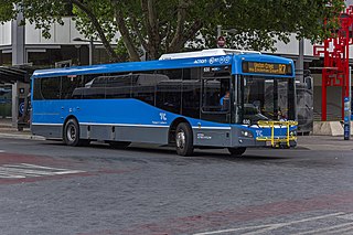
ACTION is a bus operator in Canberra, Australia, and is owned by the Government of the Australian Capital Territory.

Bolton Interchange is a transport interchange combining Bolton railway station and Bolton Bus Station in the town of Bolton in Greater Manchester, England. The station is located on the Manchester to Preston line and the Ribble Valley line, and is managed by Northern Trains. The station is 11+1⁄4 miles (18.1 km) north west of Manchester Piccadilly. Ticket gates have been in operation at the station since 2016.

Warnbro railway station is a commuter railway station in Warnbro, a suburb of Perth, Western Australia. It is on the Mandurah line, which is part of the Transperth commuter rail network, and is located immediately south-east of the interchange of Safety Bay Road and Ennis Avenue. It has two side platforms, linked by a pedestrian overpass accessed by stairs, a lift, and escalators. Services run every 10 minutes during peak, and every 15 minutes between peak. The journey to Perth Underground station is 47.5 kilometres (29.5 mi), and takes 38 minutes. The journey to Mandurah station is 23.3 kilometres (14.5 mi), and takes 13 minutes. The station has a bus interchange with seven bus stands and 12 regular bus routes.

Public transport in Christchurch, New Zealand, consists of bus services operated by two bus companies supported by a ferry, all jointly marketed as Metro, a division of Environment Canterbury (ECan).

City Interchange, formerly City Bus Station is located in the central business district of Canberra. It is a major connecting point for Transport Canberra services across the ACT, as well as commuter bus services to surrounding areas in New South Wales. Bus stands are located on Alinga Street, East Row and Mort Street, while light rail platforms are located in the median on Northbourne Avenue. The Jolimont Centre, which serves as a station for long-distance, interstate coach services is located to the west of Northbourne Avenue, within easy walking distance of all stands and platforms.

Sengkang MRT/LRT station is a Mass Rapid Transit (MRT) and Light Rail Transit (LRT) interchange station in Sengkang, Singapore. It is an interchange between the North East line (NEL) and Sengkang LRT (SKLRT). Along with Buangkok station, it is located within the Sengkang planning area.

The Canberra light rail network, also known as Canberra Metro, is a light rail system serving the city of Canberra, Australia. The initial 12-kilometre (7.5 mi) line links the northern town centre of Gungahlin to the city centre (Civic) and has 14 stops. Services commenced on 20 April 2019. The 14th stop at Sandford Street in Mitchell commenced operation in September 2021.
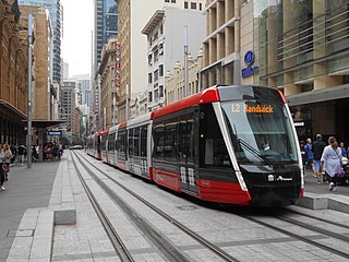
The CBD and South East Light Rail is a pair of light rail lines running between Sydney's central business district (CBD) and the south-eastern suburbs of Sydney, New South Wales, Australia. It consists of the L2 Randwick Line which runs between Circular Quay and Randwick, as well as the L3 Kingsford Line which runs between Circular Quay and Kingsford. Construction commenced in October 2015, with the L2 Randwick Line commencing services on the 14 December 2019 and the L3 Kingsford Line on the 3 April 2020. It is part of Sydney's light rail network.

Priestewitz station is on the Leipzig–Dresden railway and the Großenhain–Priestewitz railway, which branches off it. The station is in the town of Priestewitz in the German state of Saxony.

Nullarbor Avenue is a light rail station on the Canberra Metro R1 Civic to Gungahlin line, located at the intersection of Nullarbor Avenue and Flemington Road. The station was a key location during construction and testing of the light rail route and serves the suburbs of Franklin and Harrison. A crossover track is located immediately north of the platforms, making it possible for light rail vehicles to terminate here, however currently all services continue through the station. The station offers bicycle lockers in addition to "kiss and ride" bays, installed around the intersection adjacent to the station.

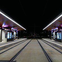
Macarthur Avenue is a light rail station on the Canberra Metro R1 Civic to Gungahlin line, located at the intersection of Northbourne Avenue, Macarthur Avenue and Wakefield Avenue. This is a major intersection bordering the suburbs of Dickson, Braddon, Turner and Lyneham. Priority for light rail vehicles arriving and departing from the station has increased traffic congestion for vehicles waiting to cross Northbourne Avenue since the line began operating. The station provides bicycle racks, however there are no "kiss and ride" or dedicated parking areas for commuters.

Swinden Street is a light rail station in Australia on the Canberra Metro R1 Civic to Gungahlin line, located on Northbourne Avenue at the intersection of Swinden Street, opposite the Lyneham sports complex. The station serves the suburbs of Lyneham and Downer, with a small dedicated park and ride that opened in December 2020. Bicycle racks are also provided for commuters adjacent to the station.

Elouera Street is a light rail station in Australia on the Canberra Metro R1 Civic to Gungahlin line, located at the intersection of Northbourne Avenue, Elouera Street and Gould Street. It is one of two stations serving the suburbs of Turner and Braddon. Bicycle racks are provided for commuters adjacent to the station. The station is close to Lonsdale Street, a popular dining and nightlife strip. Many businesses in this area were heavily impacted by road closures and delays during the construction phase, with a number of public car parks being lost to make way for light rail infrastructure contributing to prolonged accessibility issues.
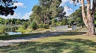
The Sullivans Creek shared path is a 3.7 km (2.3 mi) commuter cycleway in Canberra, Australia. Opened in December 1973, the path was the first off-street cycleway in Canberra and forms a trunk route from which the network extends to the districts of North Canberra, Belconnen and Gungahlin. Transport Canberra's designated cycling routes C1, C3 and C6 all traverse sections of the path, which is by far the busiest cycle route in the city.