
Belconnen is a district in the Australian Capital Territory in Australia. The district is subdivided into 27 divisions (suburbs), sections and blocks. As at the 2021 census, the district had a population of 106,061 people; and was the most populous district within the Australian Capital Territory (ACT).

Adelaide Metro is the public transport system of the Adelaide area, around the capital city of South Australia. It is an intermodal system offering an integrated network of bus, tram, and train services throughout the metropolitan area. The network has an annual patronage of 79.9 million, of which 51 million journeys are by bus, 15.6 million by train, and 9.4 million by tram. The system has evolved heavily over the past fifteen years, and patronage increased dramatically during the 2014–15 period, a 5.5 percent increase on the 2013 figures due to electrification of frequented lines.

Gungahlin is a district in the Australian Capital Territory, one of fastest growing regions in Australia. The district is subdivided into suburbs, sections and blocks. Gungahlin is an Aboriginal word meaning either "white man's house" or "little rocky hill".
Calwell is a medium-sized suburb of Canberra, Australia in the district of Tuggeranong. Tuggeranong Hill is on its southern border and the Tuggeranong Homestead is to the north. Calwell is located close to the Monaro Highway which provides a direct route to Canberra City and to Cooma.

Meadowhall Interchange is a transport interchange located in north-east Sheffield, consisting of a combined heavy rail station, tram stop and bus and coach station. The second-busiest heavy rail station in the city in terms of passenger numbers, Meadowhall Interchange provides connections between National Rail services, the Sheffield Supertram light rail network, intercity coach services and the city bus network.

Whitfords railway station is a railway station located on the boundary of Padbury and Kingsley, suburbs of Perth, Western Australia. It is on the Joondalup railway line, which is part of the Transperth commuter rail network. It is located in the median of the Mitchell Freeway, and consists of an elevated bus interchange on top of an island platform at ground level. South of Whitfords, trains run every 5 minutes during peak. North of Whitfords, trains run every 10 minutes during peak. Between peak during the day, trains run every 15 minutes. The journey to Perth railway station is 19.8 kilometres (12.3 mi), and takes 19 minutes.
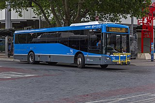
ACTION is a bus operator in Canberra, Australia, and is owned by the Government of the Australian Capital Territory.

Bonython is a suburb of Tuggeranong, a township in southern Canberra, capital city of Australia.

Chisholm is a suburb in the Canberra, Australia district of Tuggeranong, named after Caroline Chisholm.

Erindale Shopping Centre is a large shopping centre located in the Tuggeranong suburb of Wanniassa in the Canberra region of Australia. It stands on the former site of the Erindale Homestead for which it is named, and comprises 121,815.17 m2 (1,311,207.6 sq ft) of both indoor and outdoor land with 76 stores, restaurants, cafes, and entertainment venues.

Canberra railway station is located on the NSW TrainLink Regional Southern Line in the Australian Capital Territory, Australia. It is located in the Canberra suburb of Kingston.

City Interchange, formerly City Bus Station is located in the central business district of Canberra. It is a major connecting point for Transport Canberra services across the ACT, as well as commuter bus services to surrounding areas in New South Wales. Bus stands are located on Alinga Street, East Row and Mort Street, while light rail platforms are located in the median on Northbourne Avenue. The Jolimont Centre, which serves as a station for long-distance, interstate coach services is located to the west of Northbourne Avenue, within easy walking distance of all stands and platforms.

The Canberra light rail network, also known as Canberra Metro, is a light rail system serving the city of Canberra, Australia. The initial 12-kilometre (7.5 mi) line links the northern town centre of Gungahlin to the city centre (Civic) and has 14 stops. Services commenced on 20 April 2019. The 14th stop at Sandford Street in Mitchell commenced operation in September 2021.

Transport in Canberra is provided by private cars, buses, taxis and light rail, while rail, air, and long-distance coach services operate for travel beyond Canberra. A vast road network also plays a major role in transport within and beyond the city.

Route R4 is a main cross-city bus route in Canberra, Australia operated by ACTION between Belconnen, City, Woden Town Centre and Tuggeranong.

Woden Interchange was located in Woden Town Centre, Canberra, Australia, adjacent to Westfield Woden. It was served by ACTION and CDC Canberra services.

Acton Tunnel is a short road tunnel in Acton, Australian Capital Territory which opened in 1979. It carries the dual carriageway Parkes Way under a hill. The tunnel also comprises two upper levels, which have been used as an archival repository and car park by the Australian National University (ANU).

Dickson Interchange is a transport interchange in Dickson, an inner-northern suburb of Canberra. The interchange allows transfers between the Canberra Metro light rail network and local ACTION bus services. As part of the construction of the Civic to Gungahlin light rail line, a new $4 million bus interchange opened in 2018. The interchange was built on land compulsorily acquired by the ACT Government in 2015, the terms of which were not disclosed to the public. Construction allowed direct access for bus and pedestrian traffic between Northbourne Avenue and Challis Street, as well as accommodation for up to nine local bus routes, a new taxi rank, kiss and ride facilities and signalised pedestrian crossings. The new facilities became an important connection point for commuters under a redesigned timetable that integrated bus and light rail services in early 2019.

Gungahlin Place is a transport interchange located in the Gungahlin Town Centre. It is the northern terminus of the Canberra Metro R1 Civic to Gungahlin line and is an important connection point between light rail and bus transport. The current bus interchange opened on 21 April 2018. Despite the station being named Gungahlin Place, the light rail platforms are actually located on a section of Hibberson Street that has been closed to road traffic. Light rail service began in April 2019.

Alinga Street light rail station is the terminus of the Canberra Metro R1 light rail line. It opened on 20 April 2019. As the main connection point for bus services to Canberra's southern districts as well as to Queanbeyan and Yass, Alinga Street is by far the busiest station on the route, with 37% of all light rail passengers beginning or ending a journey here in the first 10 months of operation.
