
Moncton is the largest urban centre in the Canadian province of New Brunswick. Situated in the Petitcodiac River Valley, Moncton lies at the geographic centre of the Maritime Provinces. The city has earned the nickname "Hub City" because of its central inland location in the region and its history as a railway and land transportation hub for the Maritimes.
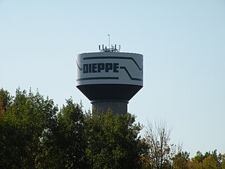
Dieppe is a city in the Canadian maritime province of New Brunswick. Statistics Canada counted the population at 25,384 in 2016, making it the fourth-largest city in the province.
Route 1 is a highway in the southern part of the Canadian province of New Brunswick. It begins in the west from the Canada–United States border at St. Stephen, and runs east for 239.11 kilometres (148.58 mi) to Route 2 at River Glade.
Route 15 is 79 kilometres (49 mi) long and is in the southeastern corner of the province of New Brunswick. Starting at the north end of the Petitcodiac River Causeway, it loops around the city of Moncton on Wheeler Boulevard, then turns northeast from Dieppe to Shediac. From there, it turns east and bypasses Cap-Pelé crossing the Scoudouc River, then southeast to meet the Trans-Canada Highway at Port Elgin. The highway is a divided freeway from Moncton to just east of Shediac, where it remains a controlled-access highway until east of Cap-Pele.
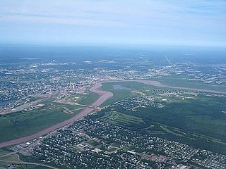
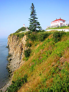
The Petitcodiac River, known informally as the Chocolate River, is a river in south-eastern New Brunswick, Canada. It is characterized by its brown mud floor and brown waters. The river has a meander length of 79 kilometres and is located in Westmorland, Albert, and Kings counties, draining a watershed area of about 2,071 square kilometres (800 sq mi). The watershed features valleys, ridges, and rolling hills, and is home to a diverse population of terrestrial and aquatic species. Ten named tributaries join the river in its course toward its mouth in Shepody Bay. Before the construction of a causeway in 1968, the river had one of the world's largest tidal bores, which ranged from 1 to 2 metres (3.3–6.6 ft) in height and moved at 5 to 13 kilometres per hour (3.1–8.1 mph). With the opening of the causeway gates in April 2010, the river is flushing itself of ocean silts, and the bore is returning to its former size.

The Magnetic Hill is an example of a gravity hill, a type of optical illusion created by rising and descending terrain. It is located at the northwestern edge of the city of Moncton in the Canadian province of New Brunswick.
Route 2 is a major provincial highway in the Canadian province of New Brunswick, carrying the main route of the Trans-Canada Highway in the province. The highway connects with Autoroute 85 at the border with Quebec and Highway 104 at the border with Nova Scotia, as well as with traffic from Interstate 95 in the U.S. state of Maine via the short Route 95 connector. A core route in the National Highway System, Route 2 is a four-lane freeway in its entirety, and directly serves the cities of Edmundston, Fredericton, and Moncton.

Salisbury, New Brunswick is a village located in Westmorland County, New Brunswick, Canada. The village's population meets the requirements for "town" status under the Municipalities Act of the Province of New Brunswick; however, its municipal status has not been changed.

Riverview is a town in Albert County, New Brunswick, Canada. Riverview is located on the south side of the Petitcodiac River, across from the larger cities of Moncton and Dieppe. Riverview has an area of 34 square kilometres (13 sq mi), and a population density of 564.6 inhabitants per square kilometre (1,462/sq mi). Riverview's slogan is "A Great Place To Grow". With a population of 19,667 in 2016, Riverview is the fifth largest municipality in New Brunswick, having a larger population than the cities of Edmundston, Bathurst, Campbellton, and Miramichi, despite its designation of "town".

Route 106 is a highway in New Brunswick, Canada; running from an intersection with Route 1 and western intersection in Route 905 in Petitcodiac to the intersection of Trans-Canada Highway and the southern terminus of Route 940 at Sackville; a distance of 91.8 kilometres.
Route 112 is a highway in New Brunswick, Canada; running from Route 114 at the south end of the Petitcodiac River Causeway in Riverview, to an intersection with Route 10 at Coles Island. The route is 88.8 kilometres long.
Route 114 is a 137.6 km (85.5 mi) Canadian secondary highway in southeastern New Brunswick.
The history of Moncton extends back thousands of years, with its first inhabitants being the First Nations of the region, such as the Mi'kmaq. Located in New Brunswick, Moncton's motto is Resurgo, which is Latin for I rise again. This motto was originally chosen in celebration of the city's rebirth in 1875 after the recovery of the economy from the collapse of the shipbuilding industry. The city again lived up to its motto in more recent times, when the economy of the city was devastated once more during the 1980s as a result of the city's largest employers all departing the city in short order. The city has since rebounded due to growth in the light manufacturing, technology, distribution, tourism, and retail sectors of the economy and is now the fastest growing city in Canada east of Toronto.
There are two major national parks. The warmest salt water beaches north of Virginia can be found on the Northumberland Strait, at Parlee Beach in Shediac. New Brunswick's signature natural attraction are only a half hour's drive down the Petitcodiac river valley. The Confederation Bridge to Prince Edward Island is only an hour's drive east of Moncton.

Coverdale is a civil parish in Albert County, New Brunswick, Canada, located along the Petitcodiac River opposite Moncton and Dieppe. It comprises one incorporated town and one local service district (LSD), both of which are members of the Southeast Regional Service Commission.
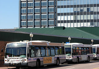
Codiac Transpo is the urban transit service of the City of Moncton, operated on behalf of Moncton, the City of Dieppe and the Town of Riverview in New Brunswick, Canada. The transit system provides express and local bus service for the residents of the Greater Moncton area and charter service throughout the southeastern area of the province. Maritime-wide bus service is provided by Maritime Bus.

This is a timeline of the history of Moncton. This page includes major weather, progress, and infrastructure events in Greater Moncton. You may also want to see List of entertainment events in Greater Moncton, or History of Moncton.

Lower Coverdale is a settlement in Albert County, New Brunswick. It is located near Riverview, Moncton, and Dieppe.
Turtle Creek is a Canadian creek in Albert County, southeastern New Brunswick. The creek drains a watershed area of 192 square kilometres, and is the primary source of potable water for Moncton, Riverview, and Dieppe, thanks to the 150 km2 (58 sq mi) Turtle Creek reservoir and the Moncton Water Treatment Plant.

Legs for Literacy is an annual marathon held in Moncton, New Brunswick, Canada in October. The race day also includes a half marathon, 10 km, and 5 km race.
