
Neubiberg is a municipality and a village in south-east of Munich, Germany, founded in 1912. It used to have an airport that was used as a Luftwaffe-base in the Third Reich and after the war as a U.S. airbase and in the following years as the German Air Force officer school. Today, the largest part of the area is used by Bundeswehr University Munich. Neubiberg consists mainly of semi-detached and detached houses and has many gardens. The village of Unterbiberg is part of the municipality. It hosts the headquarters of Infineon Technologies (Campeon) located in the west of Unterbiberg as well as the headquarters of Intel Deutschland GmbH, a wireless semiconductor business.

Kochel am See is a municipality and a town in the district of Bad Tölz-Wolfratshausen in Bavaria, on the shores of Kochelsee. The municipality consists of the districts Altjoch, Brunnenbach, Ort, Pessenbach, Pfisterberg, Walchensee and Ried.

Mantel is a municipality located in the district of Neustadt an der Waldnaab in Bavaria, Germany. It is known as a Markt, a town that was historically granted 'market rights'. The town was first mentioned in official documents in 1212, and in 1945 it was incorporated into the municipality of Rupprechtsreuth. As part of the regional reform in Bavaria, parts of the dissolved municipality of Hütten were added to it in 1972. The town's population fell by 77 people, 2.8%, to 2728 between 1988 and 2018. Mantel is best known for its nature preserve, Naturwaldreservat Gscheibte Loh, as well as its castle, Schloss Steinfels.

Ofterschwang is a municipality in southern Germany, in Oberallgäu, Bavaria. It is a professional winter sports venue, regularly used for World Cup alpine events.

Kirchlauter is a municipality in the Bavarian Administrative Region of Lower Franconia in the district of Haßberge in Germany. It is a part of the Verwaltungsgemeinde of Ebelsbach.

Ensdorf is a municipality in the district of Amberg-Sulzbach in Bavaria in Germany.

Ursensollen is a municipality in the district of Amberg-Sulzbach in Bavaria in Germany.
Rügland is a municipality in the district of Ansbach in Bavaria in Germany.
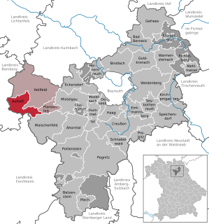
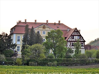
Aufseß, also sometimes spelled Aufsess, is a municipality in the district of Bayreuth in Bavaria, Germany.

Wang is a municipality in the district of Freising in Bavaria in Germany.

Riedbach is a municipality in the district of Haßberge in Bavaria in Germany. It is situated 20 km northeast of Schweinfurt and 8 km north of Haßfurt.

Neudrossenfeld is a municipality in the district of Kulmbach in Bavaria in Germany.

Kumhausen is a municipality in the district of Landshut in Bavaria in Germany.

Hohenbrunn is a municipality in the district of Munich in Bavaria, Germany.

Oberstaufen is a municipality in the district of Oberallgäu in Bavarian Swabia, Germany, situated on the B 308 road from Lindau to Immenstadt.

Schwangau is a municipality in the district of Ostallgäu in Bavaria, Germany. The village lies 4 km from the larger town of Füssen and just 1.5 km from Hohenschwangau, a collection of tourist-oriented facilities adjacent to the major tourist attractions of Schloss Neuschwanstein and Schloss Hohenschwangau.
Prackenbach is a municipality in the district of Regen in Bavaria in Germany.

Rinchnach is a municipality in the Lower Bavarian district of Regen, of Germany. As of 2000, the population was 3,261.

Chieming is a municipality in the district of Traunstein in Bavaria, Germany.

Fürstenzell is a municipality in the district of Passau in Bavaria in Germany. Fürstenzell is the birthplace of former Bayern Munich defender Klaus Augenthaler.


