Neudrossenfeld

Last updated
Neudrossenfeld
DEU Neudrossenfeld COA.svg
Location of Neudrossenfeld within Kulmbach district
Neudrossenfeld in KU.svgGuttenberg
Germany adm location map.svg
Red pog.svg
Neudrossenfeld
Bavaria location map.svg
Red pog.svg
Neudrossenfeld
Coordinates: 50°1′N11°30′E / 50.017°N 11.500°E / 50.017; 11.500
Country Germany
State Bavaria
Admin. region Oberfranken
District Kulmbach
Subdivisions45 Ortsteile
Government
   Mayor (202026) Harald Hübner [1] (CSU)
Area
  Total50.24 km2 (19.40 sq mi)
Elevation
334 m (1,096 ft)
Population
 (2022-12-31) [2]
  Total3,775
  Density75/km2 (190/sq mi)
Time zone UTC+01:00 (CET)
  Summer (DST) UTC+02:00 (CEST)
Postal codes
95512
Dialling codes 09203
Vehicle registration KU
Website www.neudrossenfeld.de

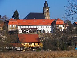
Neudrossenfeld is a municipality in the district of Kulmbach in Upper Franconia in Bavaria, Germany.

Contents

Boroughs

Church, castle and mill Neudrossenfeld.JPG
Church, castle and mill
Old bridge over Roter Main river Neudrossenfeld Brucke.JPG
Old bridge over Roter Main river

Neudrossenfeld is composed of the following boroughs:

  • Aichen
  • Altdrossenfeld
  • Berghaus
  • Brücklein
  • Buch
  • Dreschen
  • Dreschenau
  • Eberhardtsreuth
  • Eichberg
  • Eselslohe
  • Fichtelhof
  • Fohlenhof
  • Grauenthal
  • Hainbühl
  • Heidelmühle
  • Hirschgründlein
  • Hörethshof
  • Hornungsreuth
  • Igelsreuth
  • Langenstadt
  • Lehen
  • Mermettenreuth
  • Muckenreuth
  • Neudrossenfeld
  • Neuenreuth
  • Oberbrücklein
  • Oberkeil
  • Oberzinkenflur
  • Pechgraben
  • Rohr
  • Rudolphsberg
  • Schaitz
  • Schlappach
  • Schwingen
  • Tauberhof
  • Unterbrücklein
  • Untergräfenthal
  • Unterkeil
  • Unterlaitsch
  • Unterlettenrangen
  • Unterobsang
  • Unterzinkenflur
  • Waldau
  • Waldmannsberg
  • Wehelitz
  • Zoltmühle

Sport

The towns association football club TSV Neudrossenfeld, formed in 1924, celebrated its greatest success in 2014 when it won promotion to the northern division of the Bayernliga for the first time.[ citation needed ]

Related Research Articles

<span class="mw-page-title-main">Vilshofen an der Donau</span> Town in Bavaria, Germany

Vilshofen an der Donau is a town in the German district of Passau.

<span class="mw-page-title-main">Bruckmühl</span> Municipality in Bavaria, Germany

Bruckmühl is a market town in the district of Rosenheim, in Bavaria, Germany. It is situated on the river Mangfall, 16 km west of Rosenheim.

<span class="mw-page-title-main">Ergolding</span> Municipality in Bavaria, Germany

Ergolding is a municipality in the district of Landshut, in Bavaria, Germany. It is situated on the left bank of the Isar, 5 km northeast of Landshut.

<span class="mw-page-title-main">Thannhausen</span> Town in Bavaria, Germany

Thannhausen ) is a town in the district of Günzburg, in Bavaria, Germany. It is situated on the river Mindel, 24 kilometres (15 mi) southeast of Günzburg, and 33 kilometres (21 mi) west of Augsburg.

<span class="mw-page-title-main">Eggolsheim</span> Municipality in Bavaria, Germany

Eggolsheim is a municipality in the district of Forchheim in Bavaria in Germany.

<span class="mw-page-title-main">Wörnitz</span> Municipality in Bavaria, Germany

Wörnitz is a municipality in the district of Ansbach, in Bavaria, Germany. It is situated on the river Wörnitz, west of Ansbach.

<span class="mw-page-title-main">Adelshofen, Middle Franconia</span> Municipality in Bavaria, Germany

Adelshofen is a municipality in the district of Ansbach in Bavaria in Germany.

<span class="mw-page-title-main">Dürrwangen</span> Municipality in Bavaria, Germany

Dürrwangen is a municipality in the district of Ansbach in Bavaria in Germany.

<span class="mw-page-title-main">Flachslanden</span> Municipality in Bavaria, Germany

Flachslanden is a municipality in the district of Ansbach in Bavaria in Germany.

<span class="mw-page-title-main">Ohrenbach</span> Municipality in Bavaria, Germany

Ohrenbach is a municipality in the district of Ansbach in Bavaria in Germany.

<span class="mw-page-title-main">Bischofswiesen</span> Municipality in Bavaria, Germany

Bischofswiesen is a municipality in the district of Berchtesgadener Land in Bavaria in Germany.

<span class="mw-page-title-main">Heroldsbach</span> Municipality in Bavaria, Germany

Heroldsbach is a municipality in the district of Forchheim in Bavaria in Germany.

<span class="mw-page-title-main">Leuchtenberg</span> Municipality in Bavaria, Germany

Leuchtenberg is a municipality in the district of Neustadt an der Waldnaab in Bavaria, Germany, essentially a suburb of nearby Weiden in der Oberpfalz, and a larger historical region in the Holy Roman Empire governed by the Landgraves of Leuchtenberg.

<span class="mw-page-title-main">Roßhaupten</span> Municipality in Bavaria, Germany

Roßhaupten is a municipality in the district of Ostallgäu in Bavaria in Germany.

<span class="mw-page-title-main">Beratzhausen</span> Municipality in Bavaria, Germany

Beratzhausen is a market town and municipality in the district of Regensburg in Bavaria in Germany.

<span class="mw-page-title-main">Burglauer</span> Municipality in Bavaria, Germany

Burglauer is a municipality in the district of Rhön-Grabfeld in Bavaria, Germany. It lies on the river Lauer.

<span class="mw-page-title-main">Hohenroth</span> Municipality in Bavaria, Germany

Hohenroth is a municipality in the district of Rhön-Grabfeld in Bavaria in Germany.

<span class="mw-page-title-main">Brannenburg</span> Municipality in Bavaria, Germany

Brannenburg is a municipality in the district of Rosenheim in Bavaria in Germany. There is a railway station located in Brannenburg.

<span class="mw-page-title-main">Buxheim, Swabia</span> Municipality in Bavaria, Germany

Buxheim is a municipality in the district of Unterallgäu in Bavaria, Germany.

<span class="mw-page-title-main">Kist, Bavaria</span> Municipality in Bavaria, Germany

Kist is a municipality in the district of Würzburg in Bavaria in Germany.

References