HMS Sirius was the flagship of the First Fleet, which set out from Portsmouth, England, in 1787 to establish the first European colony in New South Wales, Australia. In 1790, the ship was wrecked on the reef, south east of Kingston Pier, in Slaughter Bay, Norfolk Island.

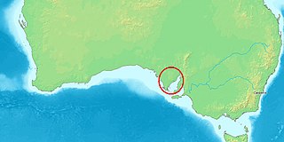
The Spencer Gulf is the westernmost and larger of two large inlets on the southern coast of Australia, in the state of South Australia, facing the Great Australian Bight. It spans from the Cape Catastrophe and Eyre Peninsula in the west to Cape Spencer and Yorke Peninsula in the east.

Port Lincoln is a city on the Lower Eyre Peninsula in the Australian state of South Australia. Known as Galinyala by the traditional owners, the Barngarla people, it is situated on the shore of Boston Bay, which opens eastward into Spencer Gulf. It is the largest city in the West Coast region, and is located approximately 280 km (170 mi) from the state's capital city of Adelaide.

Launched in 1759, the third Supply was a Royal Navy armed tender that played an important part in the foundation of the Colony of New South Wales. The Navy sold her in 1792. She then served commercially until about 1806.

HMS Hydra was a Royal Navy deep ocean hydrographic survey vessel, the third of the original three of the Hecla class. The ship was laid down as yard number 2258 on 14 May 1964 at Yarrow Shipbuilders, at Scotstoun on the River Clyde and launched on 14 July 1965 by Mary Lythall, wife of the then Chief Scientist, Basil W Lythall CB (1919–2001). She was completed and first commissioned on 4 May 1966 and, as the replacement for the survey ship HMS Owen, her commanding officer and many of her ship's company formed the first commission of HMS Hydra. She was decommissioned and sold to the Indonesian Navy in 1986 and renamed KRI Dewa Kembar ; she was still in service in 2019.

The Eyre Peninsula is a triangular peninsula in South Australia. It is bounded by the Spencer Gulf on the east, the Great Australian Bight on the west, and the Gawler Ranges to the north.
USS John Hancock was an armed steam tug in the United States Navy during the 1850s. She was named for Founding Father John Hancock and saw action against rioters in Massachusetts, filbusters in Cuba, rebels in China, and Native Americans in the Washington Territory. She took part in a hydrographic surveying expedition to East Asia and the Pacific Ocean.

His Majesty's Armed Survey Vessel Lady Nelson was commissioned in 1799 to survey the coast of Australia. At the time large parts of the Australian coast were unmapped and Britain had claimed only part of the continent. The British Government were concerned that, in the event of settlers of another European power becoming established in Australia, any future conflict in Europe would lead to a widening of the conflict into the southern hemisphere to the detriment of the trade that Britain sought to develop. It was against this background that Lady Nelson was chosen to survey and establish sovereignty over strategic parts of the continent.

John Clements Wickham was a Scottish explorer, naval officer, magistrate and administrator. He was first lieutenant on HMS Beagle during its second survey mission, 1831–1836, under captain Robert FitzRoy. The young naturalist and geologist Charles Darwin was a supernumerary on the ship, and his journal was published as The Voyage of the Beagle. After that expedition, Wickham was promoted to Commander and made captain of the Beagle on its third voyage, from 1837 and conducted various maritime expeditions and hydrographic surveys along the Australian coastline.

Tumby Bay is a coastal town situated on the Spencer Gulf, on the eastern coast of Eyre Peninsula in South Australia, 45 kilometres (28 mi) north of Port Lincoln. The town of Tumby Bay is the major population centre of the District Council of Tumby Bay, and the centre of an agricultural district farming cereal crops and sheep, as well as having established fishing and tourism industries.
Lipson is an historic farming town on the Eyre Peninsula, located only 12 km from Tumby Bay, South Australia. At the 2006 census, Lipson had a population of 209.
HMCS Integrity was a cutter built by the Colonial Government of New South Wales in 1804. She was the first vessel ever launched from a New South Wales dockyard and carried goods between the colony's coastal settlements of Norfolk Island, Newcastle, New South Wales, Van Diemen's Land and Port Jackson. In 1804 she took part in a series of voyages to Van Diemen's Land with the aim of founding a colony at Port Dalrymple, the site of the modern settlement of George Town, Tasmania.

HMS Investigator was the mercantile Fram, launched in 1795, which the Royal Navy purchased in 1798 and renamed HMS Xenophon, and then in 1801 converted to a survey ship under the name HMS Investigator. In 1802, under the command of Matthew Flinders, she was the first ship to circumnavigate Australia. The Navy sold her in 1810 and she returned to mercantile service under the name Xenophon. She was probably broken up c.1872.

HMS Dart was a schooner of the Royal Navy, built by the Barrow Shipbuilding Company, Barrow and launched in 1877 as Cruiser for Lord Eglinton. She was subsequently purchased by the Colonial Office for the use of Sir Arthur Hamilton Gordon as governor of the Fiji Islands. On his appointment to New Zealand, Cruiser was purchased by the Royal Navy as a tender for the training ship Britannia and the name changed to Dart in March 1882.

Captain Thomas Lipson was an officer in the Royal Navy, who, after a successful if unspectacular career in the Royal Navy, was appointed by the Admiralty as the first Harbour Master at South Australia, arriving there with the pioneer settlers. Serving from 1836 to 1855, based at Port Adelaide, Lipson also superintended many of the initial maritime surveys of that new colony.

The Sir Joseph Banks Group is an archipelago in the Australian state of South Australia located in Spencer Gulf about 20 kilometres (12 mi) off the eastern coast of the Eyre Peninsula. It consists of 21 islands of which eighteen are in the Sir Joseph Banks Group Conservation Park while the surrounding waters are in the Sir Joseph Banks Group Marine Park. It is considered to be an important seabird breeding site.
Francis was a 41 tons (bm) colonial schooner that was partially constructed at the Deptford Dockyard, England, and sent in frame aboard the Pitt to Australia to be put together for the purposes of exploration. The vessel had originally been designed for George Vancouver’s discovery voyage of the west coast of North America.
Lipson Cove is a tranquil sandy bay in the Australian state of South Australia on the east coast of Eyre Peninsula overlooking Spencer Gulf. It features in the 2012 book 101 Best Australian Beaches by Andy Short and Brad Farmer.
Boston Island is a 960-hectare (2,400-acre) privately owned island in Boston Bay, Spencer Gulf, South Australia. It has been primarily used for grazing sheep and was also once the location of a proposed township called Kerrillyilla at the southern end of the island. In 2009, the island was rezoned to allow for future residential and tourism development. As of 2009, it is owned by the former mayor of Port Lincoln, Peter Davis. Davis' development plans include up to 1,000 residential allotments, three tourism developments and an inland marina. Prior to rezoning, there had been little interest expressed in the development plan, despite the then mayor's enthusiasm.
Emu (sometimes "His Majesty's armed brig Emu", was a merchant ship built at Dartmouth in 1813. The British government engaged her to go out to New South Wales to serve the colony there. She spent about a year transporting people and supplies between New South Wales and Van Diemen's Land before the colonial government sent her back to England in 1816. On her way she stopped at the Cape Colony where she was wrecked in 1817.


