
In Gaelic myth, the Cailleach is a divine hag and ancestor, associated with the creation of the landscape and with the weather, especially storms and winter. The word literally means 'old woman, hag', and is found with this meaning in modern Irish and Scottish Gaelic, and has been applied to numerous mythological and folkloric figures in Ireland, Scotland, and the Isle of Man. In modern Irish folklore studies, she is sometimes known as The Hag of Beara, while in Scotland she is known as Beira, Queen of Winter.
Cú Roí mac Dáire is a king of Munster in the Ulster Cycle of Irish mythology. He is usually portrayed as a warrior with superhuman abilities and a master of disguise possessed of magical powers. His name probably means "hound of the plain/field", or more specifically, "hound of the battlefield". He is the son of Dáire mac Dedad, and thus belongs to the Clanna Dedad. However, T. F. O'Rahilly believed this to be artificial, stating that "Cú Roí and Dáire are ultimately one and the same".
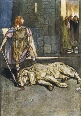
Cú Chulainn, is a warrior hero and demigod in the Ulster Cycle of Irish mythology, as well as in Scottish and Manx folklore. He is believed to be an incarnation of the Irish god Lugh, who is also his father. His mother is the mortal Deichtine, sister of king Conchobar mac Nessa.

Aífe, spelled Aoife in Modern Irish, is a character from the Ulster Cycle of Irish mythology. She appears in the sagas Tochmarc Emire and Aided Óenfhir Aífe. In Tochmarc Emire she lives east of a land called Alpi, usually understood to mean Alba (Scotland), where she is at war with a rival woman warrior, Scáthach. In Aided Óenfhir Aífe she lives in Letha, and is Scáthach's sister as well as rival – they are both daughters of Árd-Greimne of Lethra.

Táin Bó Cúailnge, commonly known as The Táin or less commonly as The Cattle Raid of Cooley, is an epic from Irish mythology. It is often called "The Irish Iliad", although like most other early Irish literature, the Táin is written in prosimetrum, i.e. prose with periodic additions of verse composed by the characters. The Táin tells of a war against Ulster by Queen Medb of Connacht and her husband King Ailill, who intend to steal the stud bull Donn Cuailnge. Due to a curse upon the king and warriors of Ulster, the invaders are opposed only by the young demigod, Cú Chulainn.

The Cliffs of Moher are sea cliffs located at the southwestern edge of the Burren region in County Clare, Ireland. They run for about 14 kilometres. At their southern end, they rise 120 metres (390 ft) above the Atlantic Ocean at Hag's Head, and, 8 kilometres to the north, they reach their maximum height of 214 metres (702 ft) just north of O'Brien's Tower, a round stone tower near the midpoint of the cliffs, built in 1835 by Sir Cornelius O'Brien, then continue at lower heights. The closest settlements are the villages of Liscannor 6 km to the south, and Doolin 7 km to the north.
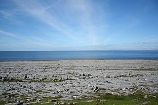
The Burren is a karst/glaciokarst landscape centred in County Clare, on the west coast of Ireland. It measures around 530 square kilometres (200 sq mi), within the circle made by the villages of Lisdoonvarna, Corofin, Gort and Kinvara. The area includes such natural features as Mullaghmore hill and Ailladie cliffs, and historic monuments such as Poulnabrone dolmen and Caherconnell Stone Fort. The Burren National Park covers a small part of the Burren and is the smallest of the six National Parks in Ireland, while the adjacent territory, including the Cliffs of Moher, is included in the Burren and Cliffs of Moher Geopark.

Lahinch or Lehinch is a small town on Liscannor Bay, on the northwest coast of County Clare, Ireland. It lies on the N67 national secondary road, between Milltown Malbay and Ennistymon, roughly 75 kilometres (47 mi) by road southwest of Galway and 68 kilometres (42 mi) northwest of Limerick. The town is a seaside resort and is home to the Lahinch Golf Club. It has become a popular surfing location.
Liscannor is a coastal village in County Clare, Ireland.

Liscannor Bay is a bay on the west coast of Ireland in County Clare. Hag's Head provides the northern border for the bay and Cream Point is the southern boundary. The village of Liscannor is located on the north side of the bay, while the village of Lahinch is on the eastern end of the bay.
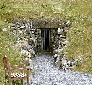
Doolin Cave is a limestone cave near Doolin in County Clare, Ireland, on the western edge of The Burren. The name is the anglicised version of the Irish name Poll an Eidhneáin, which is said to translate into "Ivy Cliff Cave". The cave attracted some controversy due to its development and marketing as a show cave in the early 21st century. It is now open to the public, branded as Doolin Cave.

Tochmarc Emire is one of the stories in the Ulster Cycle of Irish mythology and one of the longest when it received its form in the second recension (below). It concerns the efforts of the hero Cú Chulainn to marry Emer, who appears as his wife in other stories of the cycle, and his training in arms under the warrior-woman Scáthach. The tochmarc is one of the 'genres' of early Irish literature recognised in the manuscript corpus.

Moher Tower is the stone ruin of an old Napoleonic-era watchtower which stands on Hag's Head, at the southern end of the Cliffs of Moher, in County Clare, Ireland.
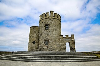
O'Brien's Tower marks the highest point of the Cliffs of Moher in County Clare, Ireland. It is located a short distance from the villages Doolin and Liscannor.
Ballard is a townland in west County Clare, Ireland. It is on the N67 national secondary road between the urban areas of Doonbeg and Kilkee. The nearest large towns are Kilrush and Kilkee, which are approximately 10 and 5 miles away, respectively.
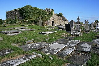
Kilmacrehy, sometimes also Kilmacreehy, is a civil parish in County Clare, Ireland. The ruins of the old parish church lie near the coastal village of Liscannor, which is also a part of the parish.

The Wild Atlantic Way is a tourism trail on the west coast, and on parts of the north and south coasts, of Ireland. The 2,500 km driving route passes through nine counties and three provinces, stretching from County Donegal's Inishowen Peninsula in Ulster to Kinsale, County Cork, in Munster, on the Celtic Sea coast.
The Hag of Beara is a mythic Irish Goddess: a Cailleach, or divine hag, crone, or creator deity; literally a "hooded one". She is associated with the Beara Peninsula in County Cork, Ireland, and was thought to bring winter. She is best known as the narrator of the medieval Irish poem "The Lament of the Hag of Beara", in which she bitterly laments the passing of her youth and her decrepit old age. The Great Book of Lecan contains a collection of stories concerning her.


