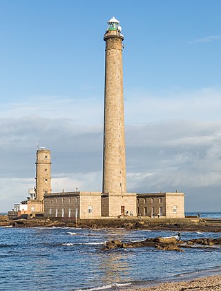
Phare de Gatteville, also known as Pointe de Barfleur Light, is an active lighthouse near Gatteville-le-Phare at the tip of Barfleur, Manche department, in the Normandy region of France. At a height of 247 feet (75 m) it is the third tallest "traditional lighthouse" in the world.
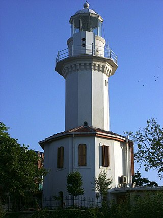
Yeşilköy Feneri is a historical lighthouse still in use located on the northern coast of Sea of Marmara at Yeşilyurt neighborhood in Istanbul's Bakırköy district, Turkey.

Lista Lighthouse is a coastal lighthouse located at the western side of the Lista peninsula, a short distance northwest of the village of Vestbygd in the municipality of Farsund in Agder county, Norway. The lighthouse sits on a cape on the edge of the Listafjorden which marks the extreme southwestern edge of the mainland of Norway. The lighthouse had a foghorn that was used from 1877 until 1987. In 1937, the station began emitting a racon signal of the morse code letter "G".

Kråkenes Lighthouse is a coastal lighthouse in Kinn Municipality in Vestland, Norway. It is located on a rocky, knife-like promontory jutting out of the northwestern tip of the island of Vågsøy.

Haugsholmen Lighthouse is a coastal lighthouse located in the municipality of Sande in Møre og Romsdal county, Norway. It is located on the tiny island of Vestre Frekøy, in the mouth of the Vanylvsfjorden, about 2.5 kilometres (1.6 mi) southwest of the island of Kvamsøya. It was established in 1876 and automated in 1979.
Nyholmen Lighthouse is a coastal lighthouse in Bodø Municipality in Nordland county, Norway. It is located on the extreme southwestern tip of a small island in the northern part of the harbour for the town of Bodø.

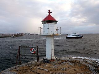
Lyngør Lighthouse is a coastal lighthouse located on the island of Kjeholmen in the Lyngør area in the municipality of Tvedestrand in Agder county, Norway. Established in 1879, the lighthouse was listed as a protected site in 1997. However, it was automated in 2004, and as a result, no one is stationed there any longer.

Almindingen is one of the largest forests in Denmark. It is located in the centre of the island of Bornholm. The forest covers 3,800 hectares, making it Denmark's third largest. Though it was at one time common grazing land for cattle, it was fenced in for forestry in 1809 by Hans Rømer, the forest supervisor. As a result, by the beginning of the 20th century, Bornholm had become Denmark's most forested region.

Hammeren is a protected area and promontory in Denmark on the northernmost point of Bornholm island. It projects into Sæne Bugt bay in the Baltic Sea. The area includes Hammersø, the largest lake on the island and the only tarn in Denmark, and a hill, 276 feet (84 m) in height, named Stejlebjerg. It is steep to the southwest but slopes gradually to the northeast, and is separated from the rest of the land by a valley.
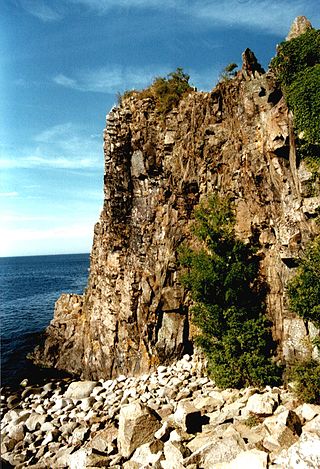
Jons Kapel is a rock bluff in Denmark on Bornholm's west coast, about 7 kilometres (4.3 mi) north of Hasle. The formations are the result of the waves beating against the rock at a time when the sea level was considerably higher than it is today. The cliff is 135 feet (41 m) in height. Named after a hermit who resided on the bluff, Jon's caves are visible from the beach below the rocks.

The Dueodde Lighthouse is located on the Danish island of Bornholm. It was built during the years 1960–62 and commissioned on 15 August 1962. It is 47 m (154 ft) in height, with a focal height of 48 m (157 ft). It is the nodal point of the southeast coast line, warning ships to keep away from the extreme southern tip of the island. Dueodde Lighthouse is Denmark's tallest lighthouse and one of the most important lighthouses of the Baltic Sea.

Svaneke Lighthouse is located southeast of Svaneke harbour on the Danish island of Bornholm. The overall height of the tower is 18 metres (59 ft).

Hammer Odde Lighthouse is located on the northernmost point of Hammeren, just outside Sandvig on the Danish island of Bornholm. A sand and gravel ocean bank, named David Bank, is situated 5.25 miles (8.45 km) from the lighthouse.
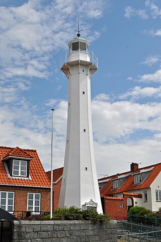
Rønne Lighthouse is located close to the waterfront in Rønne on the Danish island of Bornholm.

Christiansø Lighthouse is located on the top of the Store Tårn tower on the Danish island of Christiansø, some 18 kilometres (11 mi) northeast of Bornholm in the Baltic Sea. Constructed and brought into service in 1805, it is one of Denmark's oldest.

Blåvand Lighthouse is a seacoast lighthouse in Blåvandshuk near Esbjerg, Denmark. Built in 1900 to replace an older light, the lighthouse lies on Blåvandshuk, the westernmost point in Denmark, making Blåvand Lighthouse the country's westernmost building.

Lågskär Lighthouse is an automated lighthouse located on the north side of Lågskär, one of Finland's Åland in the Sea of Åland of the Baltic. It is the only striking feature on Lågskär on the generally uninhabited island.
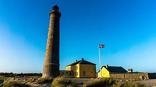
Skagen Lighthouse, also known as Skagen's Grey Lighthouse, is an active lighthouse four kilometres northeast of Skagen in the far north of Jutland, Denmark. Designed by architect Niels Sigfred Nebelong, it was brought into operation on 1 November 1858.

The Kastri Lighthouse also known as the Lighthouse of Othonoi is an active 19th-century lighthouse which marks the approaches to Othonoi the most northerly island of the Ionian archipelago.