A dune is a landform composed of wind- or water-driven sand. It typically takes the form of a mound, ridge, or hill. An area with dunes is called a dune system or a dune complex. A large dune complex is called a dune field, while broad, flat regions covered with wind-swept sand or dunes with little or no vegetation are called ergs or sand seas. Dunes occur in different shapes and sizes, but most kinds of dunes are longer on the stoss (upflow) side, where the sand is pushed up the dune, and have a shorter slip face in the lee side. The valley or trough between dunes is called a dune slack.

Sylt is a former island in northern Germany, part of Nordfriesland district, Schleswig-Holstein, and well known for the distinctive shape of its shoreline. It belongs to the North Frisian Islands and is the largest island in North Frisia. The northernmost island of Germany, it is known for its tourist resorts, notably Westerland, Kampen and Wenningstedt-Braderup, as well as for its 40-kilometre-long (25-mile) sandy beach. It is frequently covered by the media in connection with its exposed situation in the North Sea and its ongoing loss of land during storm tides. Since 1927, Sylt has been connected to the mainland by the Hindenburgdamm causeway. In later years, it has been a resort for the German jet set and tourists in search of occasional celebrity sightings.

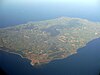
Moreton Island (Mulgumpin) is an island on the eastern side of Moreton Bay on the coast of South East Queensland, Australia. The Coral Sea lies on the east coast of the island. Moreton Island lies 58 kilometres (36 mi) northeast of the Queensland capital, Brisbane. 95% of the island is contained within a national park and a popular destination for day trippers, four wheel driving, camping, recreational angling and whale watching and a 75-minute ferry ride from Brisbane. It is the third largest sand island in the world. Together with Fraser Island, Moreton Island forms the largest sand structure in the world. It was the traditional country of the Ngugi before settlement.

Sandbanks Provincial Park is a provincial park located on Lake Ontario in Prince Edward County near Picton, Ontario, Canada. The park is considered one of the best sandy beaches in Ontario and contains the largest bay-mouth barrier dune formation in the world. The 1,550.87-hectare (3,832.3-acre) park was established in 1970 and operates year round. Birdwatching, camping, cycling, fishing, and swimming are among the activities available in the park.

Djursland is a 44 km × 33 km hilly lowland peninsula in Denmark at the entrance to the Baltic Sea, between Denmark and Sweden in Northern Europe. Djursland protrudes into the Kattegat sea, as part of the larger peninsula of Jutland, which itself extends from the Central European continent. Djursland comprises the two municipalities of Norddjurs and Syddjurs.

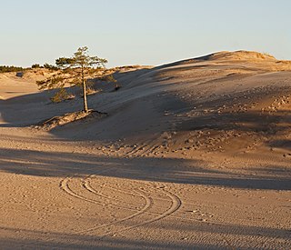
Khongoryn Els also called Duut Mankhan is popularly known as the "Singing Sands". It lies within the Gobi Gurvansaikhan National Park in Mongolia. The sand dunes extend to over 965 square kilometres (373 sq mi) area.

The Skagen Odde Nature Centre, on the northern tip of Denmark's Jutland, is a museum devoted to the effects of sand, water, wind and light. It was designed in 1989 by Jørn Utzon, the celebrated architect behind the Sydney Opera House. Under the leadership of his son Jan, the centre was completed in 2000.
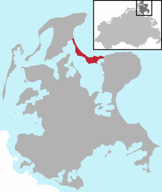
The Schaabe is a bar, almost twelve kilometres long, on the German Baltic Sea island of Rügen. It joins the peninsulas of Jasmund and Wittow.

Paradisbakkerne, also Helvedesbakkerne, is a group of hills in Denmark, located in the east of the island of Bornholm. It is situated approximately 3 kilometres (1.9 mi) northwest of Nexø. The privately owned area consists of hilly, rocky landscapes with narrow rift valleys lined by almost vertical cliffs, making it popular for nature walks. Typically, the hills rise to a height of 30–50 metres (98–164 ft) above the surroundings in a forested area which also has a number of small lakes and marshes. Midterpilt, 113 metres (371 ft) above sea level, is one of the highest points. Although much of the area is now wooded, it was once covered with heather and low shrubs, making it suitable for grazing. Paradisbakkerne has a long cultural history, attested by numerous place names with their own legends and stories. These include Slingestenen, Linkisten, Ligstenen, Dybedal, Ravnedal, Majdal, and Gamle Dam.

Almindingen is one of the largest forests in Denmark. It is located in the centre of the island of Bornholm. The forest covers 3,800 hectares, making it Denmark's third largest. Though it was at one time common grazing land for cattle, it was fenced in for forestry in 1809 by Hans Rømer, the forest supervisor. As a result, by the beginning of the 20th century, Bornholm had become Denmark's most forested region.

Rytterknægten is the highest point on the Danish island of Bornholm at 162 metres (531 ft) above sea level. The bierg is situated on a wooded bedrock of gaiter formations in the middle of Almindingen forest. Aakirkeby is located about 5 kilometres (3.1 mi) to the southeast.

Hammeren is a protected area and promontory in Denmark on the northernmost point of Bornholm island. It projects into Sæne Bugt bay in the Baltic Sea. The area includes Hammersø, the largest lake on the island and the only tarn in Denmark, and a hill, 276 feet (84 m) in height, named Stejlebjerg. It is steep to the southwest but slopes gradually to the northeast, and is separated from the rest of the land by a valley.
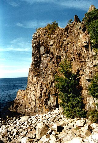
Jons Kapel is a rock bluff in Denmark on Bornholm's west coast, about 7 kilometres (4.3 mi) north of Hasle. The formations are the result of the waves beating against the rock at a time when the sea level was considerably higher than it is today. The cliff is 135 feet (41 m) in height. Named after a hermit who resided on the bluff, Jon's caves are visible from the beach below the rocks.

The Dueodde Lighthouse is located on the Danish island of Bornholm. It was built during the years 1960–62 and commissioned on 15 August 1962. It is 47 m (154 ft) in height, with a focal height of 48 m (157 ft). It is the nodal point of the southeast coast line, warning ships to keep away from the extreme southern tip of the island. Dueodde Lighthouse is Denmark's tallest lighthouse and one of the most important lighthouses of the Baltic Sea.

Hammeren Lighthouse is located on the Hammeren peninsula on the northwestern tip of the Danish island of Bornholm.
Balka, also Balke, is a village and seaside resort midway between Nexø and Snogebæk on the southwest coast of the Danish island of Bornholm. As of 2022, it has a population of 200. It is best known for its wide beach with fine white sand.

Marielyst is a small town and seaside resort some 12 kilometres (7.5 mi) south of Nykøbing on the Danish island of Falster. Its long sandy beach has led to an extensive summer house development with some 6,000 holiday homes. As of 2023, it has a population of 701.

Skagen Odde, also Skagens Odde, sometimes known in English as the Scaw Spit or The Skaw, is a sandy peninsula which stretches some 30 km (19 mi) northeast and comprises the northernmost area of Vendsyssel in Jutland, Denmark.

Dabas parks Piejūra is a nature park along the Gulf of Riga in Latvia founded in 1962. It is a protected nature reserve and a Natura 2000 location. The park stretches 36.6 kilometres (22.7 mi) over an 4,180 hectares area from Riga, through Carnikava Municipality, and up to Saulkrasti. It is a popular seasonal recreation location, notably for beach access. The park is notable for its protected biotopes, particularly its dunes and boreal forests. The park's conservation plan for 2020 onwards was developed under the "LIFE CoHaBit" project.