Hampden Bridge (Wagga Wagga)

Last updated

Hampden Bridge

WaggaWaggaBridgeOverMurrumbidgee.jpg

Hampden Bridge in 2005, prior to its 2014 demolition
Coordinates 35°06′03″S147°22′08″E / 35.1007°S 147.369°E / -35.1007; 147.369 Coordinates: 35°06′03″S147°22′08″E / 35.1007°S 147.369°E / -35.1007; 147.369
Crosses Murrumbidgee River
Locale Wagga Wagga, New South Wales
Maintained by Wagga Wagga City Council
Heritage status
Characteristics
Design Allan Truss bridge
Total length 330 feet (100 m)
Longest span 110 feet (34 m)
No. of spans 12
Piers in water 2
Clearance below 42 feet (13 m)
History
Designer Percy Allan
Construction cost ₤12,468 tender [1]
₤13,200 reported [2]
Opened 11 November 1895 [3]
Collapsed 20 August 2014
Closed October 1995 (traffic)
August 2006 (pedestrians)

The Hampden Bridge was a heritage-listed [3] wooden Allan Truss bridge over the Murrumbidgee River in Wagga Wagga, in New South Wales, Australia. It was officially opened to traffic on 11 November 1895 and named in honour of the NSW Governor Sir Henry Robert Brand, 2nd Viscount Hampden. [4] The bridge carried the Olympic Highway, formerly the Olympic Way, between 1963 until the bridge's closure to highway traffic in October 1995, replaced by the Wiradjuri Bridge. The Hampden Bridge was subsequently converted to local traffic use, then pedestrian use only, and finally demolished in 2014.

The Register of the National Estate was a heritage register that listed natural and cultural heritage places in Australia that was closed in 2007. It has been replaced by the Australian National Heritage List and the Commonwealth Heritage List and various state and territory heritage registers.

Murrumbidgee River river in New South Wales, Australia

Murrumbidgee River, a major tributary of the Murray River within the Murray–Darling basin and the second longest river in Australia. It flows through the Australian state of New South Wales and the Australian Capital Territory. It descends 1,500 metres (4,900 ft) as it flows 1,485 kilometres (923 mi) in a west-northwesterly direction from the foot of Peppercorn Hill in the Fiery Range of the Snowy Mountains towards its confluence with the Murray River near Boundary Bend.

New South Wales State of Australia

New South Wales is a state on the east coast of Australia. It borders Queensland to the north, Victoria to the south, and South Australia to the west. Its coast borders the Tasman Sea to the east. The Australian Capital Territory is an enclave within the state. New South Wales' state capital is Sydney, which is also Australia's most populous city. In September 2018, the population of New South Wales was over 8 million, making it Australia's most populous state. Just under two-thirds of the state's population, 5.1 million, live in the Greater Sydney area. Inhabitants of New South Wales are referred to as New South Welshmen.

Contents

Former structure

The Hampden Bridge was 100.5 metres (330 ft) long with each of the three truss spans 33.5 metres (110 ft) long. Hampden Bridge was the first large overhead-braced truss bridge designed by Percy Allan. [3] The bridge was originally designed to be a steel-built bridge; however, the tenders were too expensive so timber was used as an alternative. [5] The Hampden Bridge replaced the earlier bridge operated by the Wagga Wagga Bridge Company, a toll bridge over the Murrumbidgee River that operated between 1862 and 1895. [6]

Percy Allan Australian civil engineer

Percy Allan was a civil engineer who designed a large number of public works in New South Wales, including the design of 583 bridges.

Toll bridge

A toll bridge is a bridge where a monetary charge is required to pass over. Generally the private or public owner builder and maintainer of the bridge uses the toll to recoup their investment, in much the same way as a toll road.

The Roads and Traffic Authority handed over the Hampden Bridge to the Wagga Wagga City Council after the bridge was closed to traffic in October 1995. The local historic landmark remained open to pedestrians as a route between the suburb of North Wagga and the city centre until its closure in 2006. [5] In 2012, Wagga Wagga City Council voted to demolish the bridge, as the maintenance costs associated with its preservation were too high. [7] [8] The issue of whether to keep the bridge or to demolish it divided the local community. [9] On 20 August 2014, the bridge was demolished using an induced collapse method with the use of explosives.

City of Wagga Wagga Local government area in New South Wales, Australia

City of Wagga Wagga is a local government area in the Riverina region of south-western New South Wales, Australia.

Pedestrian person traveling on foot

A pedestrian is a person travelling on foot, whether walking or running. In some communities, those travelling using tiny wheels such as roller skates, skateboards, and scooters, as well as wheelchair users are also included as pedestrians. In modern times, the term usually refers to someone walking on a road or pavement, but this was not the case historically.

Central business district commercial and business centre of a city

A central business district (CBD) is the commercial and business center of a city. In larger cities, it is often synonymous with the city's "financial district". Geographically, it often coincides with the "city centre" or "downtown", but the two concepts are separate: many cities have a central business district located away from its commercial or cultural city centre or downtown.

Design of the Hampden Bridge Hampden Bridge Wagga design.jpg
Design of the Hampden Bridge

History

The Hampden Bridge opened on 11 November 1895.

In October 1995, just short of its 100th birthday, the Hampden Bridge is closed to traffic when the nearby Wiradjuri Bridge opens, on a similar alignment.

On 16 August 2006 the Hampden Bridge was closed to pedestrians indefinitely after the Wagga Wagga City Council found that the bridge deck has dropped 50 centimetres (20 in) after one of the trusses failed. A safety report by the Roads and Traffic Authority states that the bridge could fall down any day due to it being in a state of disrepair. Wagga Wagga City Council look into ways to prop up the failed section with other options of possibly demolishing the bridge. [10] [11] [12] On 25 August 2006 Wagga Wagga City Council reports that it could cost A$30,000 for emergency stabilisation with other costs such as A$10,000 or more for a structural assessment and A$25,000 to prepare for tenders for the repairs to make the Hampden Bridge safe. [13] Several days later at the monthly meeting of the Wagga Wagga City Council it was decided to commence emergency stabilisation work, a structural soundness assessment, heritage assessment and costs into demolition of the bridge. Cr Peter Dale argued that demolition was the only option since keeping the Hampden Bridge would cost the Wagga Wagga City Council hundreds of thousands of dollars to maintain after an engineer looked at the bridge and estimated that the cost for repairs would be A$100,000. [14] On month later the Wagga Wagga City Council approved A$30,000 from cash reserves for repairs or for demolition of the bridge. A report by Harry Trueman from the Institute of Engineers Australia stated that the Hampden Bridge is one of the biggest and most important timber bridges in the state since it was originally built to take produce from the Riverina to Sydney; however he is not confident that the Hampden Bridge could be saved due to the amount of money needed to restore it to a good condition, which would cost the Council millions of dollars and involve high ongoing maintenance costs. [15]

A Councillor is a member of a local government council.

Riverina Region in New South Wales, Australia

The Riverina is an agricultural region of South-Western New South Wales (NSW), Australia. The Riverina is distinguished from other Australian regions by the combination of flat plains, warm to hot climate and an ample supply of water for irrigation. This combination has allowed the Riverina to develop into one of the most productive and agriculturally diverse areas of Australia. Bordered on the south by the state of Victoria and on the east by the Great Dividing Range, the Riverina covers those areas of New South Wales in the Murray and Murrumbidgee drainage zones to their confluence in the west.

Sydney City in New South Wales, Australia

Sydney is the state capital of New South Wales and the most populous city in Australia and Oceania. Located on Australia's east coast, the metropolis surrounds Port Jackson and extends about 70 km (43.5 mi) on its periphery towards the Blue Mountains to the west, Hawkesbury to the north, the Royal National Park to the south and Macarthur to the south-west. Sydney is made up of 658 suburbs, 40 local government areas and 15 contiguous regions. Residents of the city are known as "Sydneysiders". As of June 2017, Sydney's estimated metropolitan population was 5,230,330 and is home to approximately 65% of the state's population.

By November 2007, Councillors attend a number of workshops on estimated costs of rehabilitation and demolition. The cost of rehabilitation was estimated to be A$1.5 million and demolition A$1.6 million. [16] On 27 February 2008, the Wagga Wagga City Council approved A$300,000 to make the bridge structurally safe. [16] During August 2008 a 39-metre (128 ft) metal truss (used railway tracks to put it in place) is placed on the failed section of the Hampden Bridge, to raise the deck for repair. [17]

In March 2012 the Wagga Wagga City Council voted to dismantle the Hampden Bridge. [18] A tender was awarded to Queensland-based company, Southern Cross Demolition, in February 2013 for the complete demolition of the bridge. [19] In April 2014 the Council received planning approval for the demolition of the bridge except for the bridge's pylons, [20] and demolition of the bridge commenced in June 2014. [21] By 20 August 2014 the controlled demolition of the bridge skeleton, using the induced collapse method, was completed. [22]

Related Research Articles

Georges River river

The Georges River, formerly known as Tucoerah River, is an intermediate tide dominated drowned valley estuary, located to the south and west of Sydney, New South Wales, Australia.

Wagga Wagga City in New South Wales, Australia

Wagga Wagga is a major regional city in the Riverina region of New South Wales, Australia. Straddling the Murrumbidgee River, with an urban population of more than 54,000 as at the 2016 census, Wagga Wagga is the state's largest inland city, and is an important agricultural, military, and transport hub of Australia. The ninth fastest growing inland city in Australia, Wagga Wagga is located midway between the two largest cities in Australia–Sydney and Melbourne–and is the major regional centre for the Riverina and South West Slopes regions.

Truss bridge bridge whose load-bearing superstructure is composed of a truss

A truss bridge is a bridge whose load-bearing superstructure is composed of a truss, a structure of connected elements usually forming triangular units. The connected elements may be stressed from tension, compression, or sometimes both in response to dynamic loads. Truss bridges are one of the oldest types of modern bridges. The basic types of truss bridges shown in this article have simple designs which could be easily analyzed by 19th and early 20th-century engineers. A truss bridge is economical to construct because it uses materials efficiently.

Olympic Highway highway in New South Wales

The Olympic Highway is a rural road in the central western and south-eastern Riverina regions of New South Wales, Australia. The 318-kilometre (198 mi) highway services rural communities and links the Hume Highway with the Mid-Western Highway and provides part of an alternate road link between Sydney and Albury via Bathurst and Cowra as well as servicing Wagga Wagga, linking with the Sturt Highway.

Pyrmont Bridge

The Pyrmont Bridge, a heritage-listed swing bridge across Cockle Bay, is located in Darling Harbour, part of Port Jackson, west of the central business district in the City of Sydney local government area of New South Wales, Australia. Opened in 1902, the bridge initially carried motor vehicle traffic via the Pyrmont Bridge Road between the central business district and Pyrmont. Since 1981 the bridge has carried pedestrian and bicycle traffic only, as motor vehicles were diverted to adjacent freeway overpasses. The bridge was added to the New South Wales State Heritage Register on 28 June 2002.

Hampden Bridge, Kangaroo Valley bridge in New South Wales, Australia

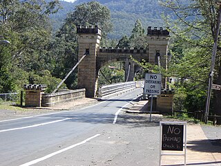
Hampden Bridge is a suspension bridge across the Kangaroo River, located in the town of Kangaroo Valley, New South Wales, Australia. It is named after Lord Hampden, Governor of New South Wales from 1895 to 1899.

Wagga Wagga Airport airport serving Wagga Wagga, Australia

Wagga Wagga Airport, is located adjacent to RAAF Base Wagga, and 5.8 nautical miles southeast of Wagga Wagga in New South Wales, Australia. The airfield is an operational base, but is leased by the Wagga Wagga City Council on a 30-year lease from the Australian Department of Defence, with RAAF Base Wagga being a ground training base. The airfield is still used by military aircraft, mostly transport aircraft transporting freight or passengers.

Lennox Bridge, Parramatta

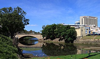
The Lennox Bridge is a heritage-listed sandstone single arch bridge across the Parramatta River, located in Parramatta in Western Sydney, New South Wales, Australia. The bridge was designed by and built under the supervision of David Lennox, the first Colonial Superintendent of Bridges using convict labour between 1836 to 1839. The Lennox Bridge is the third oldest surviving masonry bridge in New South Wales. The bridge carries Church Street, the main north-south street of Parramatta's central business district. It was added to the New South Wales State Heritage Register on 2 April 1999.

Tharwa Bridge bridge in Australia

Tharwa Bridge is a four span Allan truss bridge that provides a high-level crossing point across the Murrumbidgee River, allowing traffic between Canberra and Tharwa village. It is the oldest surviving bridge in the Australian Capital Territory.

Tom Uglys Bridge height above water

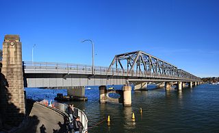
Tom Uglys Bridge is composed of two bridges, completed in 1929 and 1987, that cross Georges River in southern Sydney, in the state of New South Wales, Australia. The bridges link the St George area at Blakehurst to the Sutherland Shire at Sylvania. Tom Uglys Bridge is one of six major road crossings of Georges River.

Eric Weissel Oval was a multi-use stadium in Wagga Wagga, New South Wales, Australia. It was named after local rugby league footballer Eric Weissel and opened in 1959. It was used mostly for rugby league matches and had a capacity of 10,000 people, with a record crowd of 11,685 recorded on 20 July 1988 for the Australia vs Papua New Guinea as part of the 1985 - 1988 Rugby League World Cup where the Aussies defeated the Kumuls by a then world record score of 70-8. The oval has hosted City vs Country (ARL), National Rugby League trial games, Brumbies vs Waikato Chiefs.

Hampden Bridge is the name of two historic bridges in New South Wales, Australia, named after Lord Hampden, who was Governor of New South Wales from 1895 to 1899.

Murrumbidgee River railway bridge, Wagga Wagga bridge in Australia

The Murrumbidgee River railway bridge is a former railway bridge that carried the Main Southern railway line across the Murrumbidgee River in Wagga Wagga, Australia. The original bridge, erected in 1881, was replaced in 2006.

Main Southern railway line, New South Wales railway line in New South Wales, Australia

The Main Southern Railway is a major railway in New South Wales, Australia. It runs from Sydney to Albury, near the Victorian border. The line passes through the Southern Highlands, Southern Tablelands, South West Slopes and Riverina regions.

The history of Wagga Wagga details the growth of the city from a small crossing on the Murrumbidgee River to the largest city and regional centre of the Riverina region of New South Wales, Australia.

Historic bridges of New South Wales

This list documents historical bridges located in New South Wales, Australia. Road, rail and pedestrian bridges are listed. Generally bridges built before WWII (1939) have been included in this list.

Lachlan River railway bridge, Cowra

The Lachlan River railway bridge is a heritage-listed former railway bridge which carried the Blayney–Demondrille railway line over the Lachlan River at Cowra, Cowra Shire, New South Wales, Australia. It was designed by John Whitton in his capacity as Engineer-in-Chief for Railways. The bridge was built from 1886 to 1887 by contractors Fishburn & Co. It is also known as the Cowra Rail Bridge over Lachlan River and the Cowra Lattice Railway Bridge. The property is owned by RailCorp, an agency of the Government of New South Wales. It was added to the New South Wales State Heritage Register on 2 April 1999.

Murrumbidgee River railway bridge, Gundagai

The Murrumbidgee River railway bridge is a heritage-listed railway bridge across the Murrumbidgee River located on the Tumut railway line at Gundagai in the Cootamundra-Gundagai Regional Council local government area of New South Wales, Australia. It was built in 1903. It is also known as the Gundagai Rail Bridge over Murrumbidgee River and the Murrumbidgee River Railway Bridge. The property is owned by RailCorp, an agency of the Government of New South Wales. It was added to the New South Wales State Heritage Register on 2 April 1999.

References

  1. "The Sydney Morning Herald". The Sydney Morning Herald (17,318). New South Wales, Australia. 21 September 1893. p. 4. Retrieved 7 August 2016 via National Library of Australia.
  2. "THE NEW WAGGA BRIDGE". The Age (12,700). Victoria, Australia. 12 November 1895. p. 5. Retrieved 7 August 2016 via National Library of Australia.
  3. 1 2 3 "Hampden Bridge Wagga Wagga: Historic Engineering Marker" (PDF). Engineering Heritage Committee, Sydney Division. Institution of Engineers Australia. 1992. Retrieved 26 July 2014.
  4. "Hampden Bridge". Wagga Wagga City Council. Retrieved 23 June 2014.
  5. 1 2 "Hampden Bridge, Wagga Wagga". Timber Research Unit. Department of Architecture, University of Tasmania. Archived from the original on 12 May 2013. Retrieved 16 March 2008.
  6. "An Act to Incorporate the "Wagga Wagga Bridge Company." [Assented to, 5th December, 1861.]". New South Wales Government Gazette (276). New South Wales, Australia. 6 December 1861. p. 2633. Retrieved 7 August 2016 via National Library of Australia.
  7. Tanner, Lindsay (26 March 2012). "Hampden Bridge" (PDF). Wagga Wagga City Council . Retrieved 26 July 2014.
  8. "Hampden Bridge to go, CCTV to arrive in Wagga". ABC News. 27 March 2012. Retrieved 26 July 2014.
  9. Grimson, Ken (27 February 2013). "Residents divided over fate of beloved bridge". The Daily Advertiser. Retrieved 26 July 2014.
  10. "Council closes Hampden Bridge over sinking concerns". ABC News. 17 August 2006. Retrieved 26 July 2014.
  11. "Hampden Bridge is falling down". The Daily Advertiser. 17 August 2006. p. 3.
  12. "Wagga council urged to keep Hampden Bridge". ABC News. 22 August 2006. Retrieved 26 July 2014.
  13. "$30,000 to repair icon". The Daily Advertiser (25 August 2006). p. 2.
  14. "Council Debate Bridge stays for now". The Daily Advertiser. 29 August 2006. p. 2.
  15. "Wagga's Hampden Bridge has no future says engineer". ABC News. 25 September 2006. Retrieved 26 July 2014.
  16. 1 2 "Local bridge stays put". The Daily Advertiser. Archived from the original on 15 August 2011. Retrieved 26 July 2014.
  17. "Statement of Heritage Impact" (PDF). ngh Heritage. May 2013. p. 9.
  18. Gleeson, Ashleigh (27 March 2012). "Hampden Bridge gone to rack and ruin". The Daily Advertiser. Retrieved 26 July 2014.
  19. "Hampden Bridge given death sentence". The Daily Advertiser. 26 February 2013. Retrieved 26 July 2014.
  20. "Wagga Wagga City Council gets approval to knock down Hampden Bridge". ABC News. 14 April 2014. Retrieved 23 June 2014.
  21. Pearson, Andrew (7 June 2014). "Hampden Bridge begins to fall". The Daily Advertiser. Retrieved 23 June 2014.
  22. Owen, Brodie (20 August 2014). "Hampden Bridge erased from Wagga's landscape". The Daily Advertiser. Retrieved 20 August 2014.

Coordinates: 35°6′2.53″S147°22′6.68″E / 35.1007028°S 147.3685222°E / -35.1007028; 147.3685222