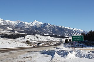
Saguache County is a county located in the U.S. state of Colorado. As of the 2020 census, the population was 6,368. The county seat is Saguache.

Montrose County is a county located in the U.S. state of Colorado. As of the 2020 census, the population was 42,679. The county seat is Montrose, for which the county is named.

Gunnison County is a county located in the U.S. state of Colorado. As of the 2020 census, the population was 16,918. The county seat is Gunnison. The county was named for John W. Gunnison, a United States Army officer and captain in the Army Topographical Engineers, who surveyed for the transcontinental railroad in 1853.

Gunnison is a home rule municipality that is the county seat and the most populous municipality of Gunnison County, Colorado. The city population was 6,560 at the 2020 United States Census. The city was named in honor of John W. Gunnison, a United States Army officer who surveyed for a transcontinental railroad in 1853. Gunnison is a college town, home to Western Colorado University.

Black Canyon of the Gunnison National Park is an American national park located in western Colorado and managed by the National Park Service. There are two primary entrances to the park: the south rim entrance is located 15 miles (24 km) east of Montrose, while the north rim entrance is 11 miles (18 km) south of Crawford and is closed in the winter. The park contains 12 miles (19 km) of the 48-mile-long (77 km) Black Canyon of the Gunnison River. The national park itself contains the deepest and most dramatic section of the canyon, but the canyon continues upstream into Curecanti National Recreation Area and downstream into Gunnison Gorge National Conservation Area. The canyon's name owes itself to the fact that parts of the gorge only receive 33 minutes of sunlight a day, according to Images of America: The Black Canyon of the Gunnison. In the book, author Duane Vandenbusche states, "Several canyons of the American West are longer and some are deeper, but none combines the depth, sheerness, narrowness, darkness, and dread of the Black Canyon."

Sandy Hook is a barrier spit in Middletown Township, Monmouth County, New Jersey, United States. The barrier spit, approximately 6 miles (9.7 km) in length and varying from 0.1 to 1.0 mile wide, is located at the north end of the Jersey Shore. It encloses the southern entrance of Lower New York Bay south of New York City, protecting it from the open waters of the Atlantic Ocean to the east.
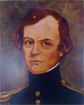
John Williams Gunnison was an American military officer and explorer.

Gunnison Beach is a beach within the Sandy Hook unit of the Fort Hancock and the Sandy Hook Proving Ground Historic District which is the Sandy Hook Unit of Gateway National Recreation Area, on the Atlantic coast of New Jersey. It is located in Middletown Township, Monmouth County, but is on federal land managed by the National Park Service. It is New Jersey's only legal clothing-optional beach. It takes its name from adjacent Battery Gunnison, which visitors must pass next to in order to get to and from the beach.

Monarch Pass is a high mountain pass in central Colorado, in the Rocky Mountains of the western United States.

Curecanti National Recreation Area is a National Park Service unit located on the Gunnison River in western Colorado. Established in 1965, Curecanti National Recreation Area is responsible for developing and managing recreational facilities on three reservoirs, Blue Mesa Reservoir, Morrow Point Reservoir and Crystal Reservoir, constructed on the upper Gunnison River in the 1960s by the U.S. Bureau of Reclamation to better utilize the vital waters of the Colorado River and its major tributaries. A popular destination for boating and fishing, Curecanti offers visitors two marinas, traditional and group campgrounds, hiking trails, boat launches, and boat-in campsites. The state's premiere lake trout and Kokanee salmon fisheries, Curecanti is a popular destination for boating and fishing, and is also a popular area for ice-fishing in the winter months.

Uncompahgre National Forest is a U.S. National Forest covering 955,229 acres in parts of Montrose, Mesa, San Miguel, Ouray, Gunnison, Hinsdale, San Juan, and Delta Counties in western Colorado. Its headquarters are in Delta County, in the city of Delta. It borders the San Juan National Forest to the south.

The Colorado and Southern Railway was an American Class I railroad in the western United States that operated independently from 1898 to 1908, then as part of the Chicago, Burlington and Quincy Railroad until it was absorbed into the Burlington Northern Railroad in 1981.
The Shavano, named for nearby Mount Shavano, was operated by the Denver and Rio Grande Railroad. The passenger train ran between Salida and Gunnison, Colorado on the railroad's historic narrow gauge route over Marshall Pass. The Shavano operated as Train #315 westbound, and #316 eastbound.
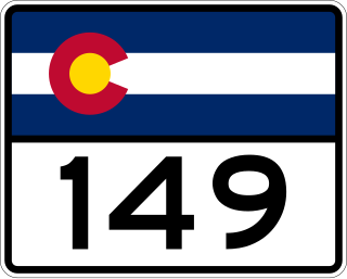
State Highway 149 (SH 149) is a 117.522-mile-long (189.133 km) state highway in southwestern Colorado, United States. SH 149's southern terminus is at U.S. Highway 160 (US 160) in South Fork, and the northern terminus is at US 50 west of Gunnison. The entire route is also known as the Silver Thread Scenic and Historic Byway.

Cottonwood Pass is a high mountain pass on the Continental Divide in south-central Colorado in the Rocky Mountains of the western United States. It is located along the border of Gunnison and Chaffee counties in Colorado, and is in the Sawatch Range. The road over Cottonwood Pass is the highest paved crossing of the Continental Divide in the U.S., and the second highest pass with an improved road in the state. It is the fourth-highest paved road in the state after Mount Evans Scenic Byway, Pikes Peak Highway, and Trail Ridge Road.

Treasure Mountain, elevation 13,535 ft (4,125 m), is a summit in the Elk Mountains of western Colorado. The mountain is in the Raggeds Wilderness southeast of Marble. The massif has been the site of marble mining and a legend of lost French gold.

East Beckwith Mountain is a prominent mountain summit in the West Elk Mountains range of the Rocky Mountains of North America. The 12,441-foot (3,792 m) peak is located in the West Elk Wilderness of Gunnison National Forest, 13.4 miles (21.5 km) west by south of the Town of Crested Butte in Gunnison County, Colorado, United States.
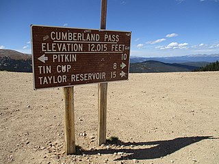
Cumberland Pass is a high mountain pass in the Sawatch Range of the Rocky Mountains of Colorado. It is located in Gunnison County and in the Gunnison National Forest. The pass divides the watersheds of West Willow Creek to the north and Quartz Creek to the south.

West Beckwith Mountain is a prominent mountain summit in the West Elk Mountains range of the Rocky Mountains of North America. The 12,185-foot (3,714 m) peak is located in the West Elk Wilderness of Gunnison National Forest, about 16.5 miles (26.5 km) southwest of Crested Butte in Gunnison County, Colorado, United States.

The West Elk Loop Scenic and Historic Byway is a 205-mile (330 km) National Forest Scenic Byway and Colorado Scenic and Historic Byway located in Delta, Garfield, Gunnison, Montrose, and Pitkin counties Colorado, USA. The byway reaches its zenith at Kebler Pass, elevation 10,007 feet (3,050 m), between Crested Butte and Paonia.