Nanded district is a district of Maharashtra state in central India. The city of Nanded is the district headquarters.

Bidar district is the northernmost part of the Karnataka state in India. The administrative headquarters of district is Bidar city. Geographically, it resembles the "Crown of the State", occupying its northeastern end. It is bounded by Kamareddy and Sangareddy districts of Telangana state on the eastern side, Latur and Osmanabad districts of Maharashtra state on the western side, Nanded district of Maharashtra state on the northern side and Kalaburagi district on the southern side.

Kalaburagi district, formerly known as Gulbarga district, is one of the 31 districts of Karnataka state in southern India. Kalaburagi city is the administrative headquarters of the district. The district is the headquarters of Kalaburagi division.
Bhalki is a City in Bidar district in the Indian state of Karnataka.
Chincholi is a panchayat town and a taluka in Kalaburagi district in the state of Karnataka, India.
Chittaguppa is a taluka and tehsil in Bidar district of Karnataka. Up until 2017, the city was under the administration of Humnabad. Chitguppa is divided into 23 wards. It is 15 kilometres (9.3 mi) from Humnabad and 53 kilometres (33 mi) from Bidar. The city is known for having the largest marketplace in the Bidar district and its corn production. An airport for Bidar and Kalaburagi was proposed in Chitgoppa, but the plan was cancelled due to high land acquisition costs and insufficient connectivity via road and rail.
Humnabad is a city and municipal council in the Bidar District of the Indian state of Karnataka. Humnabad is the headquarters of Humnabad taluk.

Maniknagar is a village located 3.5 kilometres (2.2 mi) away from Humnabad city in Bidar district in the Indian state of Karnataka. Maniknagar is a little village comprising a hamlet and a temple complex, the nucleus of which is the main temple of Manik Prabhu's Samadhi. Maniknagar is situated on the slopes of high ground near the holy confluence of two little rivulets Guru-Ganga and Viraja. The climate is by and large temperate.
Bhatambra is a village in the southern state of Karnataka, India. It is located in the Bhalki taluk of Bidar district in Karnataka.
Dubalgundi is a large village in Humnabad taluka of Bidar district in the Indian state of Karnataka.It is 15km from Humnabad and 40km from Bidar district.
Hallikhed (B) is a town in the northern part of southern state of Karnataka, India. It is located in the Humnabad taluk of Bidar district in Karnataka.
Khatak Chincholi is a village in the southern state of Karnataka, India. It is located in the Bhalki taluk of Bidar district in Karnataka. A famous 12th century Historical temple located in the village is Hulakunti Math the main god is Shree Shantalingeshwara.

Mannaekhalli is a small town in Bidar district in the southern state of Karnataka, India.It is 30km from Bidar district. It is located in the Chitguppa taluk of Bidar district in Karnataka. Mannaekhelli is the Largest village in Bidar South Constituency.

Narayanapur is a village situated 3 kilometres away from Basavakalyan taluk of Bidar district in the Indian state of Karnataka.
Rajeshwar is a village in the southern state of Karnataka, India. It is located in the Basavakalyan taluk of Bidar district in Karnataka, which is on NH-9. Rajeshwar has big "Ram Linga Swamy" temple. Rajeshwar is 16 kilometres away from its taluka Basavakalyan, 66 kilometres from Bidar and 76 kilometres from Kalaburagi.
Malkhed originally known as Manyakheta, and also known as Malkhed, is a town in Karnataka, India. It is located on the banks of Kadina River in Sedam Taluk of Kalaburagi district, around 40 km from Kalaburagi.

Jalasangvi is a village in Homnabad Taluk, Bidar district, Karnataka, India. It is located close to Dubalgundi, on the Gulbarga - Bidar state highway, at the northern end of Karnataka State. Jalasangvi is famous for its temple ruins.

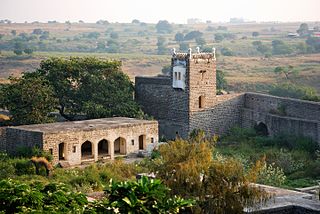
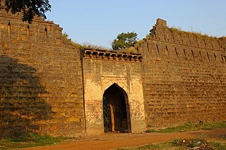
Bidar Fort is a fort located in old City area, Bidar, Karnataka, India. The fort, the city and the district are all affixed with the name Bidar. Sultan Ahmad Shah I of the Bahmanid Dynasty shifted his capital from Gulbarga to Bidar in 1427 and built his fort along with a number of Islamic monuments. There are over 30 monuments inside Bidar fort.
Umapur is a village in the Basavakalyan taluk of Bidar district in the Indian state of Karnataka.
Humnabad railway station, is an Indian Railways Train station located in Humnabad, Bidar in the Indian state of Karnataka and serves Humnabad area. It is located on the Bidar-Kalaburagi line of Secunderabad railway division in South Central Railway zone.

