
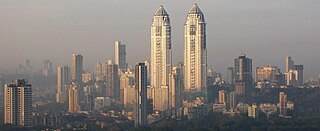
Maharashtra is a state in the western peninsular region of India occupying a substantial portion of the Deccan Plateau. Maharashtra is the second-most populous state in India and the second-most populous country subdivision globally. It was formed on 1 May 1960 by splitting the bilingual Bombay State, which had existed since 1956, into majority Marathi-speaking Maharashtra and Gujarati-speaking Gujarat. Maharashtra is home to the Marathi people, the predominant ethno-linguistic group, who speak the Marathi language, the official language of the state. The state is divided into 6 divisions and 36 districts, with the state capital being Mumbai, the most populous urban area in India, and Nagpur serving as the winter capital, which also hosts the winter session of the state legislature. Godavari and Krishna are the two major rivers in the state. Forests cover 16.47 per cent of the state's geographical area. Out of the total cultivable land in the state, about 60 per cent is used for grain crops in the Deccan region, rice in coastal Konkan, and other high rainfall areas.

Pune, also known as Poona, is one of the most important industrial and educational hubs of India, with an estimated population of 7.4 million as of 2020. As of 2021, Pune Metropolitan Region is the largest in Maharashtra by area, with a geographical area of 7,256 sq km. It has been ranked "the most liveable city in India" several times. Pune is also considered to be the cultural and educational capital of Maharashtra. Along with the municipal corporation area of PCMC, PMC and the three cantonment towns of Camp, Khadki, and Dehu Road, Pune forms the urban core of the eponymous Pune Metropolitan Region (PMR).

Pimpri Chinchwad, Pune is the northwestern city limits of Pune, India. Geographically, it is located at an altitude 590 m (1,940 ft) above sea level, at a distance of about 15 km (9.3 mi) northwest of its historic centre. The neighbourhood is home to extensive industry and is well known for its automotive, IT and manufacturing industry.

Pune district is the most populous district in the Indian state of Maharashtra. The district's population was 9,429,408 in the 2011 census, making it the fourth most populous district amongst India's 640 districts. This district has an urban population of 58.08 percent of its total. It is one of the most industrialized districts in India. In recent decades it has also become a hub for information technology.

Pune Airport is a customs airport serving the city of Pune, Maharashtra, India. It is located at Lohegaon, approximately 11 km (6.8 mi) northeast of the historic centre of Pune. The airport is a civil enclave operated by the Airports Authority of India at the western side of Lohegaon Air Force Station of the Indian Air Force. The airport serves both domestic and international flights. In financial year 2020, the airport handled over 8 million passengers. The airport is awarded as 'Best Airport by Hygiene Measures' in Asia-Pacific in 2020 by Airports Council International.
Chakan is a census town in India, in Pune district of the Indian state of Maharashtra. While agriculture remains an important factor, the town's industrial development is quickly urbanizing the area.

The Pune Municipal Corporation is the civic body that governs the inner limits of Pune, India. It is in charge of the civic needs and infrastructure of the metropolis, which is spread over an area of 484.61 sq. km. and has 3.4 million residents. Established on 15 February 1950, the executive power of the PMC is vested in the Municipal Commissioner, an Indian Administrative Service (IAS) officer appointed by the Government of Maharashtra. The position is held by Vikram Kumar, IAS.The general body of the PMC consists of 162 directly elected councilors, popularly known as "corporators", headed by a mayor. Murlidhar Mohol (BJP) was elected as the mayor and Sunita Wadekar as the deputy mayor by the newly elected in April 2021. The land for Pune Municipal Corporation was donated by Late Hon. Shri. Bhausaheb Shirole (Patil) who was second Mayor of Pune city and later became an MLC. The Pune Municipal Corporation has launched an e-Governance initiative, with the goal of leveraging Information Technology to mobilize Government resources and optimize their utilization in order to provide a superior level of service.
The economy of the state of Maharashtra is the largest in India. It is one of the most urbanised of Indian States.
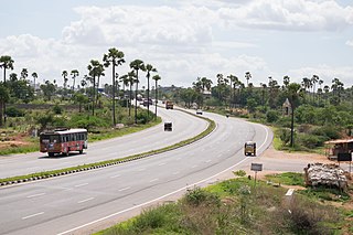
National Highway 65, , is a National Highway in India. It runs along the states of Maharashtra, Karnataka, Telangana and Andhra Pradesh. It starts at Pune and ends at Machilipatnam. Major cities on this route are Pune, Solapur, Hyderabad, Suryapet, Vijayawada and Machilipatnam. The section between Hyderabad and Vijayawada, is known as Vijayawada–Hyderabad Expressway and is a major expressway.

Maharashtra Cricket Association Stadium is a cricket stadium situated in Pune, Maharashtra, India. It is located beside the Pune Mumbai expressway in Pune district.

The Maharashtra Cricket Association is the governing body of the cricket activities in the Maharashtra state of India and the Maharashtra cricket team. It is affiliated to the Board of Control for Cricket in India.

Katraj is suburb of Pune in the Indian state of Maharashtra, and within the jurisdiction of Pune Municipal Corporation. Katraj is famous for its Peshwa-era lake that supplied water to the city during that period. The village lies at the foot of the Katraj Ghat or mountain pass on the main National Highway 4 connecting Pune with places south of the city, such as Kolhapur and Bangalore. In recent decades area surrounding the lake and the village of Katraj became part the City of Pune. The former rural area is now surrounded by residential complexes. The lakeside hosts the Rajiv Gandhi Zoological Park. Bharati Vidyapeeth, a deemed university, has its main campus here. A large Jain temple was built here in late 20th century.
Pune Metropolitan Region (PMR) is the metropolitan region around the city of Pune. According to practical purposes, PMR comprises two Municipal Corporations of PMC, PCMC and three Cantonment Boards, spread over an area of 7,256.46 km2. The population of the region as per 2011 census was 7,541,946.
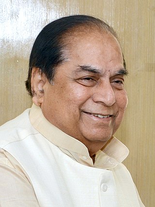
Dnyandeo Yashwantrao Patil is an Indian politician who was Governor of Bihar, state in eastern India from 29 May 2012 to 26 November 2014. He is an educator and was a leader of the Indian National Congress from Maharashtra state. He was appointed the Governor of West Bengal. On 24 December 2018, he joined Nationalist Congress Party.
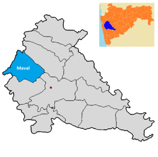
Maval taluka is a taluka in Mawal subdivision of Pune district of state of Maharashtra in India.

Pune Ring Road is a road planned for construction in and around the city of Pune, India. Pune Metropolitan Region Development Authority claimed that the road will decrease traffic congestion and provide better access to the fastest growing areas. The road will be 128 km long and will service twenty-nine villages by connecting all highways around the city. The cost is estimated at ₹104.08 billion (US$1.3 billion).
Koregaon Bhima is a panchayat village and census town in the state of Maharashtra, India, on the left (north) bank of the Bhima River. Administratively, Koregaon Bhima is under Shirur Taluka of Pune District in Maharashtra. There is only the single town of Koregaon Bhima in the Koregaon Bhima gram panchayat. The town of Koregaon Bhima is 10 km along the SH 60 motorway southwest of the village of Shikrapur, and 28 km by road northeast of the city of Pune. It is the site of the Battle of Koregaon fought on 1 January 1818.
Pune is a city in the state of Maharashtra in India. It is situated in western Maharashtra on the Deccan Plateau. Pune's public transport consists primarily of a bus service, a suburban rail service, metro, public taxis and auto rickshaws. In 2020 it was awarded the Sustainable Transport Award.
Mangdari is a village in Velhe Taluka in the Pune District of Maharashtra, India.
Jambhali is a village in the Bhor taluka in the Pune District of Maharashtra, India.