Baramati taluka

Last updated

Location of Baramati taluka in Pune district in state of Maharashtra Baramati tehsil in Pune district.png
Location of Baramati taluka in Pune district in state of Maharashtra

Baramati taluka is a taluka in Baramati subdivision of Pune district of state of Maharashtra in India. [1]

Contents

Baramati Tehsil is located in Western Maharashtra. It belongs to Pune Division. It is located 100 km towards east from district headquarters Pune. 240 km from state capital Mumbai towards east. Baramati tehsil has its head quarter that is Baramati town. Baramati tehsil lies between 18º04΄ to 18°32΄ north latitudes and 74° 26΄to 74° 69΄ east longitudes. It is located at altitude of 550 meters above means sea level. [2]  

There are 2 towns and 116 main villages in Baramati Taluka. [3] Baramati Taluka is bounded by Phaltan Taluka towards the South, Daund Taluka towards North, Indapur Taluka towards East and Purandhar Taluka towards West.

Climate and Rainfall

The climate of the Baramati Taluka is slightly different in irrigated and non-irrigated area. The winter season is from December to about the middle of February followed by summer season which last up to May. June to September is the south-west monsoon season, whereas October and November constitute the post-monsoon season. The mean minimum temperature is about 12 °C and means temperature is about 39 °C. The average annual rainfall for the period 2001 to 2012 of Baramati Tahsil was 502 mm. The rainfall analysis indicates study area is drought area (DPAP) [4]

Baramati Geomorphology Map Baramati Geomorphology Map.jpg
Baramati Geomorphology Map

Geomorphology

Baramati Taluka is located in the eastern belt of Pune district with a rolling topography and the low hills sinking slowly in to the plains with relatively broader valleys. Therefore, the physiography of the tahsil has given rise to two major characteristic land forms namely; (1) the plateau and (2) the plains. The soil of the study area is mainly derived from the Deccan basalts. [5] They are generally fertile except in hilly region. The main types of soil found in study area are black, brownish and gray or white. The soil along the Nira River area is black in colour, fine texture and fertile. The main crop in the Nira River side area is sugarcane. As we approach towards the plateau area the soil graded into coarse textured grayish to white coloured calcrete rich soil. The Tahsil area underlain by the basaltic lava flows of upper Cretaceous to lower Eocene age. Basaltic lava occupies more than 95%.

Demographics

Religions in Baramati taluk (2011) [6]
ReligionPercent
Hinduism
92.11%
Islam
4.83%
Buddhism
1.45%
Jainism
1.06%
Other or not stated
0.55%

Baramati taluka has a population of 429,600 according to the 2011 census. Baramati had a literacy rate of 82.27% and a sex ratio of 943 females per 1000 males. 47,668 (11.10%) are under 7 years of age. 73,761 (17.17%) lived in urban areas. Scheduled Castes and Scheduled Tribes make up 14.98% and 0.92% of the population respectively. [7]

Languages of Baramati taluk (2011) [8]

   Marathi (93.20%)
   Hindi (4.59%)
  Others (2.21%)

At the time of the 2011 Census of India, 93.20% of the population in the district spoke Marathi and 4.59% Hindi as their first language. [8]

Villages

See also

Related Research Articles

<span class="mw-page-title-main">Beed district</span> District in Maharashtra, India

Beed district is an administrative district in the state of Maharashtra in India. The district headquarters are located at Beed. The district occupies an area of 10,693 km² and has a population of 2,161,250 of which 17.91% were urban.

Baramati ([baːɾamət̪iː]) is a city, a tehsil and a municipal council in Pune district in the state of Maharashtra, India. The city is about 100 km southeast of the city of Pune and about 250 km from Mumbai.

<span class="mw-page-title-main">Pune division</span> Place in Maharashtra, India

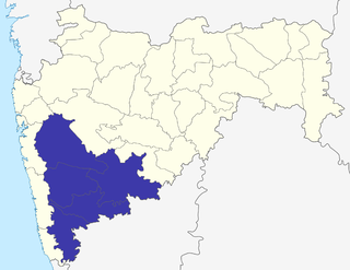
Pune Division is one of the six administrative divisions of the Indian State of Maharashtra. Pune Division is bound by Konkan Division to the west, Nashik Division to the north, Aurangabad Division to the east, and the state of Karnataka to the south.

Walwa is a taluka in Sangli district in the Indian state of Maharashtra. It is also known as Walwa-Islampur Taluka. There are ninety-five panchayat villages in Walwa Taluka.

Kadegaon is a village and taluka of Sangli district of Maharashtra in India.

<span class="mw-page-title-main">Bhor taluka</span> Taluka in Maharashtra, India

Bhor taluka is a taluka in Haveli subdivision of Pune district of state of Maharashtra in India. There are 195 villages and 1 town in Bhor Taluka.

<span class="mw-page-title-main">Daund taluka</span> Taluka in Maharashtra, India

Daund taluka is a taluka or subdivision of Pune district of the state of Maharashtra in India. The town of Daund is the only major urban area in this predominantly rural area. Daund railway station is a major railway junction. All southern railways are connected to this route, and also divided the Nagar railway to north Indian railway, like Delhi, Solapur division, Daund junction and then joined to the Pune district junction. To reach the Siddhi Vinayak Siddhatek Ganpati temple, one has to travel 14 km to Daund by road.

<span class="mw-page-title-main">Haveli taluka</span> Tehsil in Maharashtra, India

Taluka Haveli is a subdivision of the district of Pune, Maharashtra. The Pune Municipal Corporation & Pimpri Chinchwad Municipal Corporation, Pune are at the center of & entirely surrounded by the taluka for administrative purposes. The region of Pune Metropolitan Region has claimed the major part of the same.

<span class="mw-page-title-main">Indapur taluka</span> Taluka in Maharashtra, India

Indapur taluka is a taluka in Baramati subdivision of Pune district of state of Maharashtra in India.

<span class="mw-page-title-main">Khed taluka</span> Tehsil in Maharashtra, India

Khed taluka is a taluka in the subdivision, near Pune city in Pune district of the state of Maharashtra in India. Rajgurunagar is the headquarter of the taluka. The taluka is known for being the birthplace of Santaji Jagnade.The name of city is rajgurunagar on the name of Shaheed Shivram Hari Rajguru.

<span class="mw-page-title-main">Maval taluka</span> Tehsil in Maharashtra, India

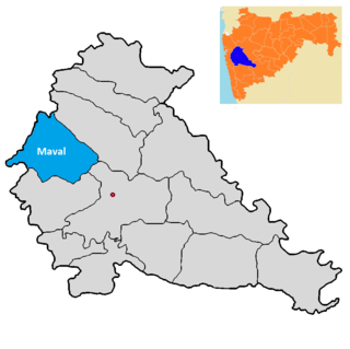
Maval taluka is a taluka in Mawal subdivision of Pune district of state of Maharashtra in India.

<span class="mw-page-title-main">Mulshi taluka</span> Tehsil in Maharashtra, India

Taluka Mulshi is a taluka in Maval subdivision of Pune district of state of Maharashtra in India. Mulshi consists of Pune Metropolitan Region & Villages.

<span class="mw-page-title-main">Purandar taluka</span> Tehsil in Maharashtra, India

Purandar taluka is a taluka of Pune district of state of Maharashtra in India. There are 108 villages and 3 towns in Purandhar Taluka.

<span class="mw-page-title-main">Shirur taluka</span> Taluka in Maharashtra, India

Shirur taluka, is a taluka in Haveli subdivision of Pune district of state of Maharashtra in India. The town is situated on the bank of river Ghod and hence it was also known as Ghodnadi in 20th Century. The town is on the border of Pune & Ahmed Nagar District and hence, main trading center for Shirur Taluka as well as Parner Taluka located in Ahmed Nagar District.

<span class="mw-page-title-main">Pune City taluka</span> Tehsil in Maharashtra, India

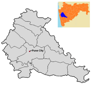
Pune City taluka is the main taluka in the Pune district of state of Maharashtra in India.

<span class="mw-page-title-main">Barshi taluka</span> Tehsil in Maharashtra, India

Barshi Taluka is one of the 11 talukas of Solapur District in the Indian state of Maharashtra. This tehsil occupies the Northeast corner of the district and is bordered by Osmanabad District to the north and east, Madha Taluka to the west, Mohol Taluka to the southwest and North Solapur Taluka to the south. The tehsil headquarters is located at Barshi, which is also the largest city in the tehsil.

<span class="mw-page-title-main">Velhe taluka</span> Tehsil in Maharashtra

Velhe Taluka, is a taluka in Haveli subdivision of Pune district of state of Maharashtra in India. The Taluka is entirely rural, and consists of 130 villages.

Murum is a village and Gram Panchayat in Baramati Taluka in Pune District of Maharashtra State, India. It belongs to Desh or Paschim Maharashtra region. It is located 78 km south of District headquarters Pune. 34 km from Baramati.

Lauki is a village in Ambegaon taluka of Pune District in the state of Maharashtra, India.The village is administrated by a Sarpanch who is an elected representative of village as per constitution of India and Panchayati raj (India). According to the 2011 census, the village has a population of 924 people.

Loni is a village in Ambegaon taluka of Pune District in the state of Maharashtra, India.The village is administrated by a Sarpanch who is an elected representative of village as per constitution of India and Panchayati raj (India). According to the 2011 census, the village has a population of 2,599 people.

References

  1. "Talukas in Pune district". Archived from the original on 10 March 2010. Retrieved 24 September 2010.
  2. "Latitude and Longitude Finder on Map Get Coordinates". www.latlong.net. Retrieved 5 October 2019.
  3. (PDF) http://censusindia.gov.in/2011census/dchb/2725_PART_B_DCHB_PUNE.pdf.{{cite web}}: Missing or empty |title= (help)
  4. (PDF) http://cgwb.gov.in/District_Profile/Maharashtra/Pune.pdf.{{cite web}}: Missing or empty |title= (help)
  5. http://cgwb.gov.in/District_Profile/Maharashtra/Pune.pdf [ bare URL PDF ]
  6. "Table C-01 Population by Religion: Maharashtra". censusindia.gov.in. Registrar General and Census Commissioner of India. 2011.
  7. "District Census Hand Book – Pune" (PDF). Census of India . Registrar General and Census Commissioner of India.
  8. 1 2 "Table C-16 Population by Mother Tongue: Maharashtra". censusindia.gov.in. Registrar General and Census Commissioner of India.


18°09′N74°35′E / 18.15°N 74.58°E / 18.15; 74.58