Daund taluka

Last updated
Daund taluka
Daund tehsil in Pune district.png
Location of Daund in Pune district in Maharashtra
Coordinates: 18°27′47″N74°34′44″E / 18.4631°N 74.5789°E / 18.4631; 74.5789
CountryFlag of India.svg  India
State Maharashtra
District Pune district
Headquarters Daund
Government
   Lok Sabha constituency supriya sule
   Assembly constituency Rahul shubhash kul
Area
   Taluka 1,307.85 km2 (504.96 sq mi)
Population
 (2011)
   Taluka 380,496
  Density290/km2 (750/sq mi)
   Urban
56,313

Daund taluka is a taluka or subdivision of Pune district of the state of Maharashtra in India. The town of Daund is the only major urban area in this predominantly rural area. Daund railway station is a major railway junction. All southern railways are connected to this route, and also divided the Nagar railway to north Indian railway, like Delhi, Solapur division, Daund junction and then joined to the Pune district junction. To reach the Siddhi Vinayak Siddhatek Ganpati temple, one has to travel 14 km to Daund by road.

Contents

In the winter season, when the temperature drops to 19 to 20°C, Daund has the most agricultural production of sugarcane. The riverbank farmers mostly plant sugarcane as their seasonal crop. The back water of the Ujani Dam riverbed region has Acacia tree forest. Many thorned-trees are found in this region. Three sugar factories are available in Daund 1)Daund sugar limited, Alegaon 2)Bhima Patas, Patas 3)Anuraj sugar limited, Yavat.

Demographics

Religions in Daund taluk (2011) [1]
ReligionPercent
Hinduism
91.05%
Islam
5.50%
Christianity
1.36%
Buddhism
1.08%
Jainism
0.59%
Other or not stated
0.42%

Daund taluka has a population of 380,496 according to the 2011 census. Daund had a literacy rate of 79.09% and a sex ratio of 939 females per 1000 males. 46,713 (12.28%) are under 7 years of age. 56,313 (14.80%) lived in urban areas. Scheduled Castes and Scheduled Tribes make up 15.05% and 2.54% of the population respectively. [2]

Languages of Daund taluk (2011) [3]

   Marathi (89.52%)
   Hindi (5.90%)
   Telugu (1.16%)
  Others (3.42%)

At the time of the 2011 Census of India, 89.52% of the population in the district spoke Marathi, 5.90% Hindi and 1.16% Telugu as their first language. [3]

See also

The Daund taluka and Pune district divided by the Bhima river from the adjoining Ahmednagar district. People of Daund have many gardening house on the Bhima river. The bhima river joins many of the sub-rivers. Some villages are getting the back water of Ujani Dam . दौंड तालुका पुणे जिल्ह्यातील प्रमुख तालुका आहे In Daund there is a Kurkumbh MIDC.

Related Research Articles

<span class="mw-page-title-main">Ahmednagar</span> City in North Maharashtra, India

Ahmednagar is a city in the Ahmednagar district, Maharashtra, India, about 120 km northeast of Pune and 114 km from Chhatrapati Sambhaji Nagar. It is the seat of its namesake district.

<span class="mw-page-title-main">Pune district</span> District in Maharashtra, India

Pune district is a district in Western Maharashtra with Administrative Headquarters in Pune city. Pune district is the most populous district in the Indian state of Maharashtra. It is one of the most industrialised districts in India.

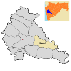
Daund is a city, municipal council, and headquarters of the Daund tehsil in the Pune district in the state of Maharashtra, India. The city of Daund is located on the Bhima River.

Indapur is a town and a municipal council in Pune district in the Indian state of Maharashtra. Indapur is known for Jahagir of Chhatrapati Shivaji Maharaj's father and grandfather. Chhatrapati Shivaji Maharaj's grandfather Malojiraje died in battle in Indapur.

<span class="mw-page-title-main">Jamkhed taluka</span> Tehsil in Maharashtra, India

Jamkhed taluka, is a taluka in Karjat subdivision of Ahmednagar district in Maharashtra State of India.

<span class="mw-page-title-main">Akole taluka</span> Tehsil in Maharashtra, India

Akole taluka is a taluka in Ahmednagar district in Maharashtra state of India. Akole consists of many places like Harishchandragad, Kalsubai, Bhandardara (Wilson) Dam, Sandhan Valley, Vishramgad etc. which attract tourists. Akole is not only famous for its natural scenery but, many historical events are also associated with it. The Western Akole is a part of Sahyadri ranges which increase its important.

<span class="mw-page-title-main">Karjat taluka</span> Taluka in Maharashtra, India

Karjat taluka is a taluka in Karjat subdivision of Ahmednagar district in Maharashtra state of western India.

<span class="mw-page-title-main">Kopargaon taluka</span> Tehsil in Maharashtra, India

Kopargaon taluka is a taluka in Shirdi subdivision of Ahmednagar district in Maharashtra state of India.

<span class="mw-page-title-main">Nagar taluka</span> Tehsil in Maharashtra, India

Nagar taluka is a taluka in Ahmednagar subdivision of Ahmednagar district in Maharashtra state of India.

<span class="mw-page-title-main">Pathardi taluka</span> Tehsil in Maharashtra, India

Pathardi taluka is a taluka in Ahmednagar subdivision of Ahmednagar district in Maharashtra state of India.

<span class="mw-page-title-main">Rahata taluka</span> Tehsil in Maharashtra, India

Rahata taluka, is a taluka in Shrirampur subdivision of Ahmednagar district in Maharashtra State of India.

<span class="mw-page-title-main">Shrigonda taluka</span> Tehsil in Maharashtra, India

Shrigonda Taluka, is a taluka in Karjat subdivision of Ahmednagar District in Maharashtra state of India. Its administrative headquarters is the town of Shrigonda.

<span class="mw-page-title-main">Shrirampur taluka</span> Tehsil in Maharashtra, India

Shrirampur taluka, is a taluka in Shrirampur subdivision of Ahmednagar district in Maharashtra state of India.

<span class="mw-page-title-main">Parner taluka</span> Tehsil in Maharashtra, India

Parner taluka is a taluka in Ahmednagar district in the state of Maharashtra in western India.

<span class="mw-page-title-main">Haveli taluka</span> Tehsil in Maharashtra, India

Taluka Haveli is a subdivision of the district of Pune, Maharashtra. The Pune Municipal Corporation & Pimpri Chinchwad Municipal Corporation, Pune are at the center of & entirely surrounded by the taluka for administrative purposes. The region of Pune Metropolitan Region has claimed the major part of the same.

<span class="mw-page-title-main">Khed taluka</span> Tehsil in Maharashtra, India

Khed taluka is a taluka in the subdivision, near Pune city in Pune district of the state of Maharashtra in India. Rajgurunagar is the headquarter of the taluka. The taluka is known for being the birthplace of Santaji Jagnade.The name of city is rajgurunagar on the name of Shaheed Shivram Hari Rajguru.

<span class="mw-page-title-main">Purandar taluka</span> Tehsil in Maharashtra, India

Purandar taluka is a taluka of Pune district of state of Maharashtra in India. There are 108 villages and 3 towns in Purandhar Taluka.

<span class="mw-page-title-main">Pune City taluka</span> Tehsil in Maharashtra, India

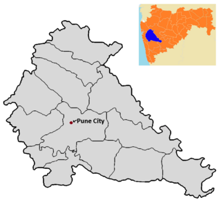
Pune City taluka is the main taluka in the Pune district of state of Maharashtra in India.

Murum is a village and Gram Panchayat in Baramati Taluka in Pune District of Maharashtra State, India. It belongs to Desh or Paschim Maharashtra region. It is located 78 km south of District headquarters Pune. 34 km from Baramati.

Chikhalthan is a village in the Kannad taluka of Aurangabad district in Maharashtra State, India.

References

  1. "Table C-01 Population by Religion: Maharashtra". censusindia.gov.in. Registrar General and Census Commissioner of India. 2011.
  2. "District Census Hand Book – Pune" (PDF). Census of India . Registrar General and Census Commissioner of India.
  3. 1 2 "Table C-16 Population by Mother Tongue: Maharashtra". censusindia.gov.in. Registrar General and Census Commissioner of India.